
California Historical Landmarks in Imperial County facts for kids
Do you know that Imperial County in Southern California is home to many amazing historical places? These spots are called California Historical Landmarks. They help us remember important events and people from California's past.
Let's explore some of these cool landmarks in Imperial County! Each one tells a unique story about the area's rich history.
Contents
- Discovering Imperial County's Past
- Camp Pilot Knob
- Camp Salvation
- Charley's World of Lost Art
- Fort Yuma
- Hernando de Alarcón Expedition
- Mission Puerto de Purísima Concepción
- Mountain Springs Station
- Picacho Mines
- Plank Road
- Fort Romualdo Pacheco
- Site of Mission San Pedro y San Pablo de Bicuñer
- Tecolote Rancho Site
- Tumco Mines
- Yuha Well
- Images for kids
Discovering Imperial County's Past
Imperial County has many special places that are officially recognized as California Historical Landmarks. These landmarks include old forts, mission sites, and important travel routes. They show us how people lived, traveled, and explored this part of California long ago.
Camp Pilot Knob
Camp Pilot Knob was a big training area for soldiers during World War II. It was part of the Desert Training Center, which was set up by Major General George S. Patton, Jr.. This camp helped prepare soldiers for fighting in desert conditions. It's located near Felicity.
Camp Salvation

Camp Salvation is a historic site in Calexico. It was an important stop for people traveling to California during the California Gold Rush. Many people came through this area hoping to find gold. Today, the Calexico City Hall stands on this historic spot.
Charley's World of Lost Art

Charley's World of Lost Art is a unique place near Andrade. It's part of a group of special art environments created by folk artists. These places show amazing creativity and imagination.
Fort Yuma

Fort Yuma is an old fort located in Winterhaven. It was an important military post in the 1800s. The fort helped control the crossing of the Colorado River and protect travelers.
Hernando de Alarcón Expedition

The Hernando de Alarcón Expedition marks the spot where Hernando de Alarcón explored the Colorado River in 1540. He was one of the first Europeans to travel through this area by water. This expedition helped map the region. It's located near Winterhaven.
Mission Puerto de Purísima Concepción

The Mission Puerto de Purísima Concepción was a Spanish mission founded in 1781. It was located near Fort Yuma in Winterhaven. This mission was part of Spain's efforts to establish control and spread Christianity in California.
Mountain Springs Station

Mountain Springs Station was a vital stop on the old Butterfield Overland Mail route. This route was used by stagecoaches to carry mail and passengers across the country in the mid-1800s. It's located near Jacumba.
Picacho Mines

The Picacho Mines were once busy gold mines in the desert. They played a big role in the local economy during the gold rush era. These mines are located near Winterhaven.
Plank Road

The Plank Road was a unique road made of wooden planks built across the sand dunes. It was a very important route for cars and trucks traveling between Yuma and El Centro before modern highways existed. It's near Winterhaven.
Fort Romualdo Pacheco

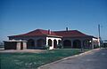
Fort Romualdo Pacheco was another important fort in Imperial County. It was located on the west bank of the New River near Imperial. Today, the Imperial Valley College Museum is on this historic site.
Site of Mission San Pedro y San Pablo de Bicuñer
The Site of Mission San Pedro y San Pablo de Bicuñer was another Spanish mission founded in 1781. It was located near Bard. Like other missions, it aimed to connect with and convert local Native American tribes.
Tecolote Rancho Site

The Tecolote Rancho Site near Holtville was once the home of famous author Harold Bell Wright. He wrote many popular novels in the early 1900s, often inspired by the American West.
Tumco Mines
.jpg)
The Tumco Mines were a significant gold mining area near Ogilby. Tumco was once a bustling mining town, and its remains tell the story of the gold rush in this desert region.
Yuha Well

Yuha Well is a natural water source that was incredibly important for travelers crossing the desert. It provided much-needed water for Native Americans, explorers, and pioneers for thousands of years. It's located near Seeley.
Images for kids
-
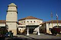
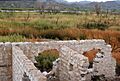
The site of Camp Salvation, now Calexico City Hall.
-
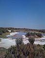
A view near Andrade, where Charley's World of Lost Art is located.
-
A historical marker at Fort Yuma.
-
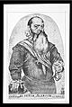
A portrait of Hernando de Alarcón.
-
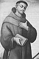
A portrait of Francisco Garcés, who was involved with the missions.
-
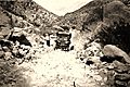
The Mountain Springs grade around 1920.
-
An old ore mill at Picacho Mines.
-
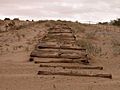
A section of the historic Plank Road.
-
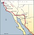
An old map showing the area near Fort Romualdo Pacheco.
-
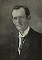
A portrait of Harold Bell Wright.
-
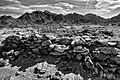
The historic mining town of Tumco.
-
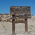
Yuha Well, an important water source.
