
California Historical Landmarks in Nevada County facts for kids
Nevada County in Northern California is a place rich in history, especially from the exciting days of the California Gold Rush. Many important spots here are recognized as California Historical Landmarks. These landmarks are special places, buildings, or areas that tell us about California's past. They help us remember the people and events that shaped the state.
This list will introduce you to some of these amazing historical landmarks in Nevada County. Each one has a unique story, from gold discoveries and old mines to important inventions and famous people. Let's explore these cool historical sites together!
Contents
- Historical Landmarks in Nevada County
- Alpha Hydraulic Diggings
- Bridgeport Covered Bridge
- Discovery of Gold at Gold Hill
- Donner Monument
- Empire Mine
- First Manufacturing Site of the Pelton Wheel
- First Transcontinental Railroad-Truckee
- Holbrooke Hotel
- Home of Lola Montez
- Home of Lotta Crabtree
- Mount Saint Mary's Convent and Academy
- National Exchange Hotel
- Nevada Theatre
- North Bloomfield Mining and Gravel Company
- North Star Mine Powerhouse
- Omega Hydraulic Diggings
- Overland Emigrant Trail
- Rough and Ready
- South Yuba Canal Office
- World's first long-distance telephone line
- Images for kids
Historical Landmarks in Nevada County
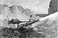
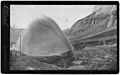
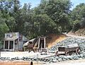
Alpha Hydraulic Diggings
The Alpha Hydraulic Diggings are located near Washington. This site shows where a special type of gold mining, called hydraulic mining, took place. Miners used powerful jets of water to wash away hillsides and find gold. It was a very effective but also very impactful way of mining.
Bridgeport Covered Bridge
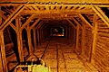
The Bridgeport Covered Bridge is found near French Corral. This beautiful bridge crosses the Yuba River. It is one of the longest single-span wooden covered bridges in the United States. Imagine how many people and wagons crossed this bridge long ago!
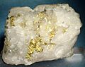
Discovery of Gold at Gold Hill
Near Grass Valley, Gold Hill is where gold was first discovered in Nevada County. This happened in 1850. This discovery led to a huge rush of miners to the area. It helped make Grass Valley an important mining town.
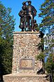
Donner Monument
The Donner Monument is located in Donner Memorial State Park near Truckee. This monument honors the Donner Party. They were a group of pioneers who faced extreme hardships while trying to cross the Sierra Nevada mountains in 1846-1847. It's a reminder of the challenges early settlers faced.
Empire Mine
The Empire Mine, in Grass Valley, was one of California's oldest and richest gold mines. It operated for over 100 years! Miners dug deep underground to extract gold. Today, it's a state historic park where you can learn about hard rock mining.
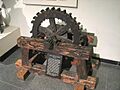
First Manufacturing Site of the Pelton Wheel
In Nevada City, you can find the site where the first Pelton wheel was made. This amazing invention was a type of water turbine. It was used to generate power, especially for mining operations. It helped make mining more efficient.
First Transcontinental Railroad-Truckee
The town of Truckee played a key role in the construction of the First Transcontinental Railroad. This massive project connected the eastern and western United States. Building the railroad through the Sierra Nevada mountains was a huge challenge. Many Chinese immigrants worked tirelessly on this part of the railway.
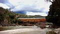
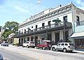
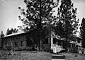
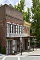
Holbrooke Hotel
The Holbrooke Hotel is a historic building in Grass Valley. It opened in 1851 and has hosted many famous guests. These include presidents and writers. It's a great example of the grand hotels from the Gold Rush era.
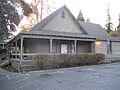
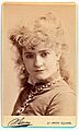
Home of Lola Montez
In Grass Valley, you can see the former home of Lola Montez. She was a famous dancer and actress from Europe. She lived here during the Gold Rush. Her home is a reminder of the interesting people who came to California.
Home of Lotta Crabtree
Also in Grass Valley is the home of Lotta Crabtree. She was a child star who became a very popular actress. She started her career performing for miners. Her story shows how entertainment grew during the Gold Rush.
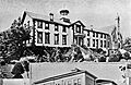
Mount Saint Mary's Convent and Academy
This historic site in Grass Valley was once a convent and a school for girls. It was founded by the Sisters of Mercy. It played an important role in providing education and care in the early days of the town.
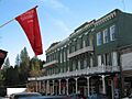
National Exchange Hotel
The National Exchange Hotel is a landmark in Nevada City. Built in 1856, it is one of the oldest continuously operating hotels in California. It has seen many historical events and welcomed countless travelers.
Nevada Theatre
The Nevada Theatre, located in Nevada City, is the oldest existing theater building in California. It opened in 1865. It has hosted plays, movies, and concerts for over a century. It is still used for performances today.
North Bloomfield Mining and Gravel Company
This site is part of Malakoff Diggins State Historic Park. It represents one of the largest hydraulic gold mining operations. The massive scale of the mining here changed the landscape. It also led to important legal battles over environmental damage.
North Star Mine Powerhouse
The North Star Mine Powerhouse is in Grass Valley. It was part of the North Star Mine, another major gold mine. The powerhouse used advanced technology, including a large Pelton wheel, to power the mining operations.
Omega Hydraulic Diggings
Similar to the Alpha Diggings, the Omega Hydraulic Diggings are also near Washington. This site shows more evidence of the large-scale hydraulic mining that took place in the area. These operations were vital to gold production.
Overland Emigrant Trail
The Overland Emigrant Trail, near Grass Valley, is a section of the historic California Trail. This trail was used by thousands of pioneers. They traveled west in search of new opportunities, especially during the Gold Rush.
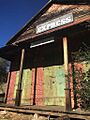
Rough and Ready
The town of Rough and Ready is a unique historical landmark. It was founded by miners in 1849. For a short time, it even tried to secede from the United States! It's known for its independent spirit.
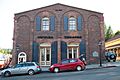
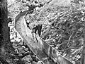
South Yuba Canal Office
In Nevada City, the South Yuba Canal Office was the headquarters for a major water delivery system. This canal brought water to mines and towns. It was crucial for hydraulic mining and for daily life in the Gold Rush era.
World's first long-distance telephone line
Near French Corral, you can find the site of the world's first long-distance telephone line. This line was built in 1878. It connected French Corral to French Lake. This was a huge step forward in communication technology!
Images for kids
-
Alpha Hydraulic Diggings
-
Bridgeport Covered Bridge
-
Discovery of Gold at Gold Hill
-
Donner Monument
-
Empire Mine
-
First Manufacturing Site of the Pelton Wheel
-

First Transcontinental Railroad-Truckee
-
Holbrooke Hotel
-
Home of Lola Montez
-
Home of Lotta Crabtree
-
Mount Saint Mary's Convent and Academy
-
National Exchange Hotel
-
Nevada Theatre
-
North Bloomfield Mining and Gravel Company
-
North Star Mine Powerhouse
-
Omega Hydraulic Diggings
-
Overland Emigrant Trail
-
Rough and Ready
-
South Yuba Canal Office
-
World's first long-distance telephone line


.jpg)


