Callao, Missouri facts for kids
Quick facts for kids
Callao, Missouri
|
|
|---|---|

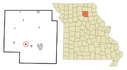
Location in Macon County and the state of Missouri
|
|
| Country | United States |
| State | Missouri |
| County | Macon |
| Area | |
| • Total | 0.52 sq mi (1.34 km2) |
| • Land | 0.52 sq mi (1.34 km2) |
| • Water | 0.00 sq mi (0.00 km2) |
| Elevation | 837 ft (255 m) |
| Population
(2020)
|
|
| • Total | 251 |
| • Density | 485.49/sq mi (187.54/km2) |
| Time zone | UTC-6 (Central (CST)) |
| • Summer (DST) | UTC-5 (CDT) |
| ZIP code |
63534
|
| Area code(s) | 660 |
| FIPS code | 29-10486 |
| GNIS feature ID | 2393496 |
Callao is a small city in Macon County, Missouri, in the United States. In 2020, about 251 people lived there. This number was a bit lower than in 2010, when 292 people called Callao home.
History of Callao
Callao was first planned out in 1858. This was just one year before the railroad reached the area. The town needed a name, and the story of how it got its name is quite interesting!
People in the town didn't know what to call it. So, they hung a world map on a wall. Then, they blindfolded a man and had him point to the map. His finger landed on a port city in Peru called Callao. That's how this Missouri city got its unique name! A post office opened in Callao in 1859.
A special building called the Johnson Morrow House is in Callao. It was added to the National Register of Historic Places in 1994. This means it's an important historical building that should be protected.
Geography of Callao
Callao is located in the southwestern part of Macon County. A major road, U.S. Route 36, runs just south of the city. This road goes east about 8 miles (13 km) to Macon, which is the main town of the county. To the west, the road goes about 25 miles (40 km) to Brookfield.
Another road, Missouri Route 3, goes right through the middle of Callao. It's known as Chestnut Street in the city. This route goes north about 33 miles (53 km) to Kirksville. It also goes south about 24 miles (39 km) to Clifton Hill.
The city of Callao covers an area of about 0.52 square miles (1.35 km2), and all of it is land. Water from the city flows into the Middle Fork of the Little Chariton River. It also drains into Stinking Creek, which is another stream that joins the Middle Fork. All this water eventually flows into the big Missouri River.
Population Facts
| Historical population | |||
|---|---|---|---|
| Census | Pop. | %± | |
| 1870 | 310 | — | |
| 1880 | 330 | 6.5% | |
| 1890 | 371 | 12.4% | |
| 1900 | 498 | 34.2% | |
| 1910 | 526 | 5.6% | |
| 1920 | 542 | 3.0% | |
| 1930 | 468 | −13.7% | |
| 1940 | 398 | −15.0% | |
| 1950 | 370 | −7.0% | |
| 1960 | 329 | −11.1% | |
| 1970 | 373 | 13.4% | |
| 1980 | 326 | −12.6% | |
| 1990 | 332 | 1.8% | |
| 2000 | 291 | −12.3% | |
| 2010 | 292 | 0.3% | |
| 2020 | 251 | −14.0% | |
| U.S. Decennial Census | |||
The population of Callao has changed over the years. In 2010, there were 292 people living in the city. There were 112 homes, and 81 of these were families.
Most people living in Callao in 2010 were White. A small number were African American or Native American. Some people were also of Hispanic or Latino background.
About 26.7% of the people in Callao were under 18 years old. About 11.6% were 65 years old or older. The average age of people in the city was about 39.8 years. The number of males and females was almost equal.
See also
 In Spanish: Callao (Misuri) para niños
 | Jackie Robinson |
 | Jack Johnson |
 | Althea Gibson |
 | Arthur Ashe |
 | Muhammad Ali |

