
Camino Real in New Mexico facts for kids
The Camino Real in New Mexico was a very old and important road. It was the northern part of a huge road called the Camino Real de Tierra Adentro. This road started in 1598 and went all the way from Mexico City in Mexico, through parts of Texas, and up to San Juan Pueblo in what is now New Mexico.
This historic road helped people travel and trade for hundreds of years. It was like a superhighway of its time, connecting important places and allowing goods and ideas to move between them.
Important Parts of the Road
Many parts of the Camino Real in New Mexico are now protected because they are so important to history. They have been added to the National Register of Historic Places. This means they are recognized as special places that should be preserved.
These sections were added to the list in different years, starting in 2011. They help us remember the long journey and the people who traveled this path.
The Camino Real de Tierra Adentro was a very long trade route, about 2,560 kilometers (1,590 miles) long! It connected Mexico City to San Juan Pueblo from 1598 until 1882. It was one of the main "royal roads" that the Spanish used to connect their big cities during the time they explored and settled the Americas.
Here are some of the areas where parts of the Camino Real are protected, listed from south to north:
- Doña Ana County, New Mexico (This county is right next to the border with Mexico.)
- Parts of the road here include the Rincon Arroyo-Perrillo Section and the San Diego North South Section.
- Sierra County, New Mexico (This county is just north of Doña Ana County.)
- Important sections here are the Point of Rocks Section and the Yost Draw Section.
- Socorro County, New Mexico (This county is north of Sierra County.)
- Sections near old pueblos like Qualacu Pueblo and San Pascual Pueblo are protected.
- Santa Fe County, New Mexico (This is further north, closer to the end of the trail.)
- Many sections here are protected, including the Alamitos Section, the La Bajada Mesa Section, and parts near El Rancho de las Golondrinas.
Quick facts for kids |
|
|
Camino Real-Jornada Lakes Section
|
|
| Lua error in Module:Location_map at line 420: attempt to index field 'wikibase' (a nil value). | |
| Nearest city | Engle, New Mexico |
|---|---|
| Area | 98 acres (40 ha) |
| Built | 1598 |
| MPS | Camino Real in New Mexico, AD 1598-1881 MPS |
| NRHP reference No. | 11000167 |
| Added to NRHP | April 8, 2011 |
One specific part, the Camino Real-Jornada Lakes Section, is near Engle, New Mexico. It dates back to 1598, the year the road was established. This section was added to the National Register of Historic Places in 2011.
Historic American Engineering Record (HAER) No. NM-15, "La Bajada Historic Trails and Roads, Approximately 1 mile East/Northeast of intersection of State Highway 16 and Indian Service Road 841, La Bajada, Santa Fe County, NM", 19 photos, 6 measured drawings, 27 data pages, 3 photo caption pages
Images for kids
-
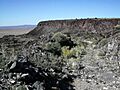
This image might show a part of the historic Camino Real, possibly the La Bajada Mesa Section.
-
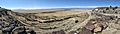
La Bajada Hill has many turns, called switchbacks. This picture shows them from above on La Bajada Mesa, with the town of La Bajada, New Mexico and the Santa Fe River below.

