
Caja del Rio facts for kids
Quick facts for kids Caja del Rio |
|
|---|---|
|
Lua error in Module:Location_map at line 416: Malformed coordinates value.
|
|
| Highest point | |
| Elevation | 7,326 ft (2,233 m) |
| Geography | |
| Location | Santa Fe County, New Mexico, New Mexico, United States |
| Geology | |
| Type of rock | Cinder cones, spatter cones basalt outflows |
The Caja del Rio is a large, flat area in northern Santa Fe County, New Mexico, USA. Its name means "box of the river" in Spanish. This special place was formed by volcanoes and covers about 84,000 acres.
People also call it "the Caja," "Caja del Rio Plateau," or "Cerros del Rio." It's located about 15 miles (23 km) west of Santa Fe, New Mexico. Most of the Caja is managed by the United States Forest Service as part of the Santa Fe National Forest. You can reach it using New Mexico Highway 599, Santa Fe County Road 62, and Forest Service Road 24.
Contents
Exploring the Caja del Rio Plateau
The Caja del Rio Plateau is mostly flat or gently rolling. But it also has many steep, cone-shaped hills that rise up to 800 feet high. The tallest points in this area include Cerro Micho (7,326 feet), Montoso Peak (7,315 feet), Ortiz Mountain (7,188 feet), and Cerro Rito (7,296 feet).
All the water from the Caja flows into the Rio Grande. Some parts drain directly into the Rio Grande. Other parts drain into two smaller rivers first: the Santa Fe River and Cañada Ancha.

Almost the entire edge of the Caja is surrounded by cliffs or steep slopes called escarpments. White Rock Canyon forms the northwest side of the plateau. This canyon, where the Rio Grande flows, is over 1000 feet deep in some places. Bandelier National Monument is just across the river to the west.
Along the eastern edge is Cañada Ancha, a stream that flows north into the Rio Grande. Another deep canyon, about 400 feet deep, runs along the southern edge. The Santa Fe River cuts through this canyon. This river canyon separates the Caja from another area called the Mesita de Juana Lopez Grant.
The western edge of the plateau has a large escarpment. You can easily see it when driving north on Interstate 25 from Albuquerque to Santa Fe. This part of the plateau is known as La Bajada (Spanish for "the descent"). Tetilla Peak (7,203 feet) is a main feature here.
How the Caja del Rio Was Formed (Geology)
The Caja del Rio plateau is a volcanic field. This means it's an area with many volcanoes that erupted over time. It has about 60 cinder cones (small, steep volcanoes), spatter cones (even smaller cones made of lava blobs), and basalt (a type of volcanic rock) flows.
The volcanoes here formed because the Caja is near where two big cracks in the Earth's crust meet. These are the Rio Grande Rift and the Jemez Lineament. The Rio Grande Rift is a huge crack where the Earth's crust is pulling apart. It runs from Colorado, through New Mexico, and into Mexico. It started forming about 30 million years ago.
The Jemez Lineament is an older crack that runs from southwest to northeast. It connects many volcanic areas across Arizona and New Mexico. These cracks make the Earth's crust thinner. This allows hot, melted rock (magma) from deep inside the Earth to rise to the surface and erupt.
The lava that erupted in the Caja is varied. Some lavas are low in silica (a common mineral in rocks) and are called basalt. Other lavas have more silica and are called dacite. The lavas often mixed with melted crust as they rose. Some lavas even show signs of coming from a very old, sunken piece of Earth's crust called the Farallon plate.
There are also basalt flows on the west side of White Rock Canyon. These are part of the Caja del Rio volcanic field too. They are similar to the basalt found at mid-ocean ridges (underwater mountain ranges where new crust forms).
The Caja isn't the only volcanic area nearby. About 20 miles (32 km) to the northwest is the Valles Caldera. This is a huge, bowl-shaped crater formed by a massive volcanic eruption. It's at the center of the Jemez Mountains. The Jemez Mountains were built by many eruptions over millions of years. The last big eruptions, between 2 and 3 million years ago, are thought to have created the Caja del Rio volcanic field.
Weather in the Caja del Rio
The Caja del Rio has a dry climate. It's also a continental climate, meaning it has big temperature changes between seasons.
In January, the average high temperature is about 39.7 degrees Fahrenheit (4.3°C). In July, it's about 80.5 degrees Fahrenheit (26.9°C). The average low temperature in January is 18.8 degrees Fahrenheit (-7.3°C), and in July, it's 54.4 degrees Fahrenheit (12.4°C).
On average, the Caja gets about 10-12 inches (25-30 cm) of rain each year. Most of this rain comes from summer thunderstorms. The area also gets snow in the winter.
Plants and Animals of the Caja del Rio
The soils in the Caja del Rio come from volcanic rock. They are often stony or cindery and not very deep. This means they don't hold water and nutrients very well.
Three main plant groups grow on the Caja del Rio plateau:
- Pinon-juniper savanna: This has scattered pinon (Pinus edulis) and juniper (Juniperus monosperma) trees with short grasses underneath.
- Pinon-juniper woodland: This has more trees, often 100 to 300 trees per acre.
- Great Basin sage scrub: This has lots of shrubs.
Other common plants include blue grama (Bouteloua gracilis) and galleta (Pleuraphis jamesii) grasses. Common shrubs are chamisa (Ericameria nauseosa), Apache plume (Fallugia paradoxa), four-wing saltbush (Atriplex canescens), and big sagebrush (Artemisia tridentata).
Many animals live in the Caja del Rio:
- Predators: You might see black bears, mountain lions, bobcats, coyotes, foxes, gray foxes, ringtails, badgers, and different types of skunks and weasels.
- Other Mammals: There are also Rocky Mountain elk, mule deer, raccoons, porcupines, jackrabbits, cottontail rabbits, and many kinds of mice and gophers. A small herd of about 50 wild horses lives here all year.
- Birds of Prey: Look for bald eagles, golden eagles, red-tailed hawks, ferruginous hawks, Swainson's hawks, American kestrels, and peregrine falcons.
- Other Birds: Resident birds include Merriam's turkey, pinyon jays, hairy woodpeckers, and scaled quails. Many migratory birds also visit, like turkey vultures, killdeers, mourning doves, and various songbirds.
- Waterfowl: Birds like Canada geese, mallards, and northern pintails use the Rio Grande corridor.
- Reptiles: Common reptiles include collared lizards, roundtail horned lizards, striped whipsnakes, and western diamondback rattlesnakes.

People and the Caja del Rio
Long ago, the Pueblo people built many villages on the Caja del Rio and Pajarito plateaus. The Caja has many petroglyphs (rock carvings) carved into the basalt rock.
When Europeans settled Santa Fe in 1610, they likely started using the Caja del Rio for grazing their animals. For a long time, people used the plateau as common land for summer grazing and cutting timber. In the 1800s, commercial ranching grew. By the 1890s, too many animals were grazing, which, along with droughts, damaged the land. Grasses were replaced by shrubs and trees.
In the early 1900s, the Forest Service began to fix the damaged rangelands. They reduced grazing permits and started programs to improve the land. In 1935, the government bought parts of the Caja del Rio. This land became the Caja del Rio Unit of the Santa Fe National Forest.
Today, the Caja is managed for community grazing. The Forest Service allows a certain number of cattle to graze there each year. The area has many improvements like earth tanks, wells, pipelines, and fences to help manage the livestock.
Fun Places to Visit in the Caja
Since 2004, people have worked to create recreational trails on the Caja. These trails are mainly used by mountain bikers and horse riders. The goal is to add more ways for people to enjoy the Caja, not to stop grazing.
Wild Horses of the Caja
The United States Forest Service has named Caja del Rio a Wild Horse Territory. They manage a herd of mustangs (wild horses) here. There's also another group of feral horses nearby that are not managed. These are thought to be domestic horses that were recently let go.
Diablo Canyon: A Cool Spot for Adventure
Caja del Rio Canyon, also known as Diablo Canyon, is a popular place for rock climbing. It's in the northern part of Cañada Ancha, close to where it meets the Rio Grande. You can get there by Camino La Tierra and Old Buckman Road. It has a large parking area, even though it's not marked.
The canyon walls have impressive trap rocks (a type of dark, fine-grained rock). The flat, sandy bottom of the canyon can have amazing flash floods during the summer monsoon season. Hiking from Diablo Canyon to the Rio Grande is very scenic and easy. This area is also popular with horse riders.
Old Buckman Road continues past Diablo Canyon to the site of Buckman. Buckman was once a logging town and a train stop. You can sometimes cross the Rio Grande at Buckman. This crossing used to be a major route between Santa Fe and the Pajarito Plateau.
Diablo Canyon was even used as a filming location for the 2007 movie 3:10 to Yuma.
Trails for Exploring the Caja
The Caja has about 100 miles of mapped trails. Some of the well-known trails include:
- Chino Mesa Trail: An 8-mile (one way) road that goes north from 1100 Well to an overlook of White Rock Canyon.
- Montoso Peak Trail: A 12-mile loop road that goes west from 1100 Well around the north side of Montoso Peak.
- Frijoles Canyon Overlook: A 2.6-mile (one way) trail that goes west from Montoso Peak to the edge of White Rock Canyon. It also goes down into the canyon across from Frijoles Canyon in Bandelier National Monument.
- Sagebrush Flats Trail: A 17-mile loop road that goes north from 1100 Well (or 700 Well) into the northern part of the Caja, above Diablo Canyon.
- Soda Springs Trail: A 3.1-mile (one way) hiking trail that goes southwest from Buckman and climbs up to Sagebrush Flats.
- Caja del Rio/Diablo Canyon Trail: A 1.3-mile (one way) hiking trail that goes southwest from Diablo Canyon and climbs up to Sagebrush Flats.
- Twin Hills Loop: An 18-mile loop road that passes through 1200 Well and Headquarters Well.
The Future Rio Grande Trail
There's a plan for a long trail called the Rio Grande Trail. If it extends north of Bernalillo, it might run along the base of the Caja del Rio.
Images for kids
-
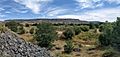
La Bajada Mesa from the valley of the Santa Fe River at La Bajada, New Mexico. The old El Camino Real de Tierra Adentro road is visible at the top center.
-
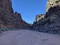
Looking down Caja del Rio Canyon

_in_Santa_Fe_National_Forest,_New_Mexico.jpg)
