Campbell Lake (Anchorage, Alaska) facts for kids
Quick facts for kids Campbell Lake |
|
|---|---|

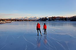
Two ice skaters on Campbell Lake in winter
|
|
| Location | Anchorage, Alaska |
| Coordinates | 61°07′57″N 149°56′29″W / 61.1324772°N 149.9413973°W |
| Lake type | Reservoir |
| Primary inflows | Campbell Creek |
| Primary outflows | Campbell Creek estuary into Turnagain Arm |
| Catchment area | 72 sq mi (190 km2) |
| Basin countries | United States |
| Max. length | 1.3 mi (2.1 km) |
| Surface area | 5,344,864 sq ft (123 acres) |
| Average depth | 1.5 m (4 ft 11 in) |
| Max. depth | 5.6 m (18 ft) |
| Water volume | 851,102 m3 (30,056,400 cu ft) |
| Shore length1 | 18,603 ft (5,670 m) |
| Surface elevation | 10 ft (3.0 m) |
| Islands | None |
| Settlements | Anchorage, Alaska |
| 1 Shore length is not a well-defined measure. | |
Campbell Lake is a large lake located in Anchorage, Alaska. It is unique because it was created by people, not by nature. This makes it an artificial lake, also known as a reservoir.
Campbell Lake is a popular spot for different activities. It is also home to many types of fish and wildlife.
Contents
How Campbell Lake Was Made
Campbell Lake was formed in the late 1950s. A person named David Alm built a large dirt wall, called an earthen dam, across Campbell Creek. This dam stopped the water flow. It created the lake over wet, marshy land that was once affected by ocean tides.
Some well-known people live by the lake. For example, a former newspaper publisher, Alice Rogoff, welcomed US President Barack Obama to her home there in 2015.
Dam Challenges and Repairs
The dam at Campbell Lake has faced problems over the years. It broke during the big 1964 Alaska earthquake and again in 1989. The 1989 break happened because of very heavy rains. These rains caused the water flowing into the lake to increase almost 20 times.
More recently, during the 2018 Anchorage earthquake, a sewer pipe under the lakebed moved out of place. To fix this, the lake had to be drained in May 2019 so repairs could be made.
Lake Water and Wildlife
Campbell Lake gets its water from a part of the Chugach Mountains. This water flows through the Campbell Creek area. The lake's water then flows out into a shallow area called an estuary that connects to Turnagain Arm.
Water Temperatures and Size
The lake's water temperature changes with the seasons. In summer, the surface water is warmer than the deeper water. In winter, it's the opposite: the surface is colder, often around 0 degrees Celsius (32 degrees Fahrenheit), while the deeper water is a bit warmer. Surface temperatures can reach about 18 degrees Celsius (64 degrees Fahrenheit) in July.
Campbell Lake covers about 123 acres. This makes it the largest lake in Anchorage, Alaska. However, if you combine nearby Lake Hood and Lake Spenard, which are connected, they would be larger.
Fish Species and Fishing Rules
Several types of fish live in Campbell Lake. These include coho salmon, chinook salmon, and blackfish. The Alaska Department of Fish and Game has added coho salmon to the lake. This helps support sport fishing in the creeks upstream from the lake.
However, it is important to know that fishing is not allowed in Campbell Lake itself.
Public Access to Campbell Lake
For a long time, many people thought Campbell Lake was private. But in September 2019, an investigative report (a detailed news story) suggested that the lake was actually public under Alaska law.
In December 2019, the City of Anchorage and the State of Alaska made a joint statement. They confirmed that the lake is open to the public for "boating and all forms of permissible recreation." This means people can use the lake for fun activities.
Ways to Reach the Lake
There are three main ways the public can legally get to Campbell Lake:
- By water: You can use Campbell Creek to reach the lake.
- By air: You can fly in using a floatplane or other small aircraft.
- By land: There are two public easements. An easement is a legal right to use someone else's land for a specific purpose. These easements allow you to reach the lake "without permission" from private property owners. They were officially surveyed and marked in January 2020.
 | Kyle Baker |
 | Joseph Yoakum |
 | Laura Wheeler Waring |
 | Henry Ossawa Tanner |


