Canaan, Indiana facts for kids
Quick facts for kids
Canaan
|
|
|---|---|

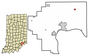
Location of Canaan in Jefferson County, Indiana
|
|
| Country | United States |
| State | Indiana |
| County | Jefferson |
| Township | Shelby |
| Area | |
| • Total | 0.28 sq mi (0.73 km2) |
| • Land | 0.28 sq mi (0.73 km2) |
| • Water | 0.00 sq mi (0.00 km2) |
| Elevation | 951 ft (290 m) |
| Population
(2020)
|
|
| • Total | 72 |
| • Density | 255.32/sq mi (98.42/km2) |
| ZIP code |
47250
|
| FIPS code | 18-10036 |
| GNIS feature ID | 2587014 |
Canaan is a small community in Indiana, United States. It is located in Jefferson County and is known as a "census-designated place" (CDP). This means it is a special area identified by the government for gathering information, even though it is not officially a town or city. As of the 2010 census, about 90 people lived there.
Contents
History of Canaan
Canaan began to grow slowly around 1812 when John Warfield started his farm. The name "Canaan" was first used in 1832. A man named Amos Simpers is often seen as the founder of Canaan. This is because he sold the first land lots along what is now State Road 62. The official map of Canaan was filed in 1836.
Indian-Kentuck Baptist Church
The Indian-Kentuck Baptist Church was formed in 1814. It moved to its current spot northwest of downtown Canaan around 1844 or 1865. The church has become more active in the community in recent years. It helps by running a food pantry twice a month. The church also takes part in the Jefferson County fair and has many other programs to help people in the area.
Canaan Methodist Church
The Canaan Methodist Church was started in 1830 by several families. The cemetery next to the church has graves dating back to 1829. The land for the church was given by Amos Simpers in 1834. Over the years, the church had three different buildings. The first was made of logs and was located a bit northwest of the final church site. The second and third buildings were built next to the graveyard in the 1840s and 1868. A store was opened near the church in 1866 by Joseph Lochard and later run by his family.
Early Businesses in Canaan
In the 1840s and 1850s, Canaan had several businesses. A tavern, which is like an inn or pub, was opened in 1829. In 1837, Ephraim and Coy Kennedy started a store. By 1840, they had a tobacco factory that employed seven people. This factory made a lot of cigars! For example, they produced 780,000 cigars in 1850. By 1878, Canaan also had a drug store.
Social Centers and Groups
Canaan had social groups that brought people together. The Canaan Lodge of the Independent Order of Odd Fellows was officially started in 1872. Another group, Canaan Lodge 393 of Free & Accepted Masons, was first organized in 1868. It was later reestablished as Canaan Lodge 583 in 1890. These lodges were places where people could meet and socialize.
Public Services and Schools
A high school opened in Canaan in 1872, providing education for older students. Mail delivery for Canaan used to come through the Barbersville post office. However, on November 29, 1938, William C. Sullivan became the first postmaster for Canaan's own post office. Today, Canaan has the Canaan Elementary School for younger students.
Canaan Fall Festival
The Canaan Fall Festival is a special event held every year in Canaan. It is famous for hosting the longest-running annual Pony Express ride. The festival takes place on the third weekend in September. Visitors can find many interesting things for sale, such as antiques, collectibles, crafts, jewelry, fresh produce, and furniture.
Geography of Canaan
Canaan is located in the northeastern part of Jefferson County. It is in the center of Shelby Township. State Roads 62 and 250 both pass through the community. They run along the eastern and southern sides of Canaan.
- State Road 62 goes northeast about 21 miles to Dillsboro. It also goes southwest about 11 miles to the northern edge of Madison, which is the main town in Jefferson County.
- State Road 250 goes east about 7 miles to Pleasant. It also goes southwest about 6 miles to U.S. Route 421. From there, U.S. Route 421 goes south about 7 miles to the center of Madison.
According to the U.S. Census Bureau, the Canaan CDP covers a total area of about 0.28 square miles (0.73 square kilometers). A very small part of this area, about 0.26%, is water. The center of Canaan drains north into the Indian Kentuck Creek valley. This creek then flows south to the Ohio River. The western edge of Canaan drains west into Toddys Branch, which also flows into Indian Kentuck Creek.
Population Information
| Historical population | |||
|---|---|---|---|
| Census | Pop. | %± | |
| 2020 | 72 | — | |
| U.S. Decennial Census | |||
As of the 2020 census, the population of Canaan was 72 people.
See also
 In Spanish: Canaan (Indiana) para niños
 | Roy Wilkins |
 | John Lewis |
 | Linda Carol Brown |


