Canning Contour Channel facts for kids
The Canning Contour Channel is a 16-kilometer (about 10-mile) long system. It includes man-made concrete channels and metal pipelines. This system is located in the Darling Scarp area of Western Australia. It was built between July 1935 and December 1936.
This project was part of a public works program during the Great Depression. Its main goal was to carry drinking water from Canning Dam. The water flowed through the hills near Roleystone and Kelmscott. It then reached a station near Gosnells. The channel followed the natural shape of the Canning Valley. This meant the water moved entirely by gravity, without needing pumps. When the channel needed to cross a valley, special pipes were used. From Gosnells, the water then entered the city's main water pipes.
The channel provided drinking water to Perth from 1940 to 1975. It became less important after the Canning Tunnel was built in the mid-1970s. Until the Serpentine Dam was finished in 1961, Canning Dam and this channel were Perth's main water sources. Today, many parts of the old channel and its structures still exist. They are now popular routes for bushwalkers.
In 1950, a part of the channel broke near Araluen. This caused serious water shortages in Perth for several weeks.
Where Does the Channel Go?
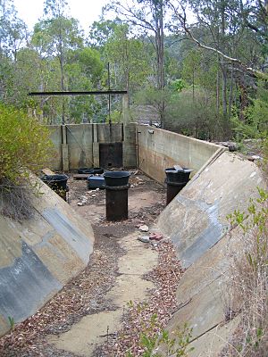
The channel begins at a special chamber on the north side of the Canning River. This is just below the Canning Dam. After about 200 meters, the water enters a siphon. A siphon is a pipe that helps water flow uphill and then downhill, crossing obstacles. This siphon helps the channel cross the Canning River.
The channel then runs next to McNess Drive, following the Canning Valley. Another siphon helps it cross McNess Drive and the Canning River again. The channel continues north of Croyden Road into Roleystone. It crosses Brookton Highway using another siphon. The channel then goes west and northwest. It crosses Peet Road and follows Contour Road. It uses a siphon to cross Slab Gully. More channels and siphons continue west. They cross Canning Mills Road and then go north. Finally, the channel crosses Turner Road on its way to its end point in Martin.
How Was the Channel Built?
The Public Works Department built the channel. It was designed for the Metropolitan Water Supply. Several important engineers, including Russell Dumas, helped design it. Other engineers supervised the building work. This was the same team that had worked on the Canning Dam. Construction started in June 1935 and finished in January 1937.
Building the channel was a big technical challenge. The hilly land made it hard to use machines. So, a lot of the work was done by hand. Many unemployed men worked on the project. This gave them jobs during the Great Depression.
Before the channel was fully completed, water from Canning Dam went to Perth through pipelines. Once the dam was full, these pipelines were no longer needed. A larger pipeline then carried water from Gosnells to Cannington. From there, it was sent to Fremantle and Kings Park.
When the construction was finished, 320 men were laid off. The total cost of the project was £125,000. This was actually less than the estimated cost of £155,000.
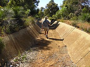
The channel usually looked like a concrete ditch. It was about 1.5 meters (5 feet) wide at the bottom. Its sides sloped up at a 45-degree angle. At the top, the channel was about 3 meters (10 feet) wide and 1 meter (3 feet) deep. Workers dug the channel from the ground or rock. Then, they lined it with concrete. This concrete was made from local cement and a type of rock called laterite.
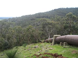
When the channel crossed shallow valleys, cast iron pipes were used. These pipes were joined with lead seals. For deeper valleys, steel pipes were used and joined by welding.
Another channel also ran north from Canning Dam. This channel allowed water from Canning Dam to refill Mundaring Weir. This channel is now inside the dam's water area, so people cannot access it. There was also a channel from Kangaroo Gully that fed water into Canning Dam.


