Serpentine Dam (Western Australia) facts for kids
Quick facts for kids Serpentine Dam |
|
|---|---|

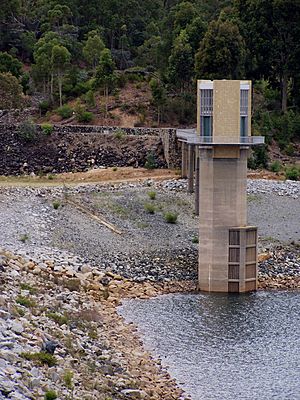
Dam wall and offtake tower. Water level in picture is 27% of capacity.
|
|
| Location | Serpentine, Western Australia, Australia |
| Coordinates | 32°24′15″S 116°05′58″E / 32.40417°S 116.09944°E |
| Opening date | 1961 |
| Dam and spillways | |
| Height | 55 m (180 ft) |
| Width (base) | 350.5 m (1,150 ft) |
| Reservoir | |
| Creates | Reservoir |
| Total capacity | 137,700,000 m3 (4.86×10⁹ cu ft) |
| Catchment area | 664 km2 (256 sq mi) |
| Surface area | 5.01 km (3.11 mi) |
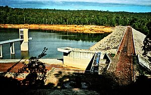
The Serpentine Dam is a very important water supply dam for Perth, Western Australia. It holds a lot of water and lets it out slowly. This helps control the water level in the Serpentine Pipehead Dam reservoir. From there, water goes to homes and businesses in the city as needed. The dam was finished being built in 1961.
The Serpentine Dam is one of many dams built in Western Australia since the 1920s. It is part of the Integrated Water Supply System (IWSS). This system is managed by the Water Corporation. It provides water to over two million people in Perth, Mandurah, and other areas. The Serpentine Dam is linked to the Serpentine Pipehead Dam. This second dam stores water from Serpentine Dam and other nearby dams.
The Serpentine Dam is a key water source for the Perth metropolitan area. It supplies about 39 gigalitres (1.4 billion cubic feet) of water each year. An extra 2 gigalitres (71 million cubic feet) comes from natural flows into the Serpentine Pipehead Dam. Since 2010, the Serpentine Dam alone has supplied water to about 4300 homes every year.
Contents
History of Perth's Water Supply
Perth has had problems with water shortages since 1829. Back then, only rich people had tanks on their roofs to collect rainwater. Others got water from shallow wells, but these only had water for a few months a year. People also used swamps, lakes, and some freshwater springs.
With limited water, sources often became dirty. This led to diseases like typhoid and diphtheria spreading quickly. Many people, especially those with less money, became very sick.
In 1885, a group called the Sanitation Commission was formed. They stopped the use of dirty cesspits. They also set up four main ways for people to get drinking water. These included wells, rainwater tanks on roofs, and water from Lake Monger and other lagoons. Rivers and streams from the Darling Scarp also provided water. The Commission wanted to pipe clean water from the Darling Scarp. However, this plan was too expensive. People also worried the water might get dirty.
In 1887, civil engineers Henry John Saunders and James Barratt created a new plan. They suggested building a dam on Munday Brook at Carmel. This dam would cover 13 hectares (32 acres). It would hold 640 million litres (140 million imperial gallons) of water. This was enough to supply about 25,000 people. At the time, Perth and Fremantle together had only 11,500 people. This meant each person could get about 140 litres (30 imperial gallons) of water daily. This plan was very important. It helped Perth grow during the state's gold rush. It also solved the water shortage problems that had lasted over 50 years.
Many dams have been built since this first water plan. It was the start of all the different water supply systems in Perth. These include the Goldfields Water Supply Scheme and the Serpentine Scheme. The Serpentine Scheme led to the building of the Serpentine Dam. It was built between 1960 and 1961 and opened in 1961.
How Serpentine Dam Works
The Serpentine Dam is located in the Darling Plateau, within the Darling Scarp. It is about 12 kilometres (7.5 mi) south of Jarrahdale, Western Australia. The area is mostly open woodland and private land. Some private land has been cleared for farming.
The Water Corporation says the Serpentine Dam can hold 138 billion litres (4.9 billion cubic feet) of water. Its wall is 55 metres (180 ft) high from its lowest point. The reservoir, which is the lake behind the dam, is 16 kilometres (9.9 mi) long. The area that collects water for the dam, called the catchment, is 664 square kilometres (256 sq mi). The reservoir is 217 metres (712 ft) above sea level. The highest point in the catchment, Mount Cuthbert, is 582 metres (1,909 ft) above sea level.
The area gets about 1,000 millimetres (39 in) of rain each year. Most of this rain falls between May and September. Rainfall can vary a lot across the catchment. It can be 700 millimetres (28 in) in the east and up to 1,300 millimetres (51 in) in the west.
Environmental Challenges
Less Water Flow
Climate change and less rainfall have affected Western Australia for a long time. This impacts water supplies. The Serpentine Dam area saw a 16% drop in rainfall between 1961 and 2008. Then, it dropped another 10% from 2008 to 2015. This caused the amount of water flowing into the dam to drop by 58%.
In 2015, the Serpentine Main and Pipehead dams had very little water flowing in. It was only 1.7 gigalitres (60 million cubic feet). This is much lower than the 100–140 gigalitres (3.5–4.9 billion cubic feet) that used to flow in before the mid-1970s. Experts predict that in the future, water flowing into the dams could drop by 45% or even up to 70%. It might even be close to zero.
In 2011, Perth's water supplies were very low because of little rain. The Water Corporation said Perth needed 176 billion litres (6.2 billion cubic feet) of water that year. Otherwise, they would have to limit how much water homes and businesses could use.
Bauxite Mining Impacts
Most of the dam catchments for the IWSS are in south-western Western Australia. A company called Alcoa has mined for bauxite ore in these areas since 1963. Bauxite is used to make aluminum. This mining has affected the northern Jarrah forest, including the Serpentine catchment.
Mining involves clearing forests and removing soil. It also means blasting and removing rock. The company has started replanting the lost forest areas. They plan to replace the lost forest by 2032. This replanting is expected to increase water flow to the Serpentine Dam by 3.5% between 2011 and 2030. However, it is predicted to decrease overall by 4.5% between 2030 and 2050.
Water Quality Risks
Germs, called Pathogens, are always a danger to water supplies. They can make people sick or even cause death. So, water in the Serpentine Dam catchment is treated regularly. How land is used around the dam can affect water treatment. For example, driving off-road on unofficial tracks causes erosion. Erosion makes soil particles get into the water. These particles can make the water cloudy, which is called turbidity. Germs can stick to these soil particles. This can make it harder to clean the water. It increases the risk of the water becoming contaminated. Erosion also harms plants and vegetation in the area.
Land Uses Around the Dam
Private Land Use
About 1,355 hectares (3,350 acres) of private land is on the south-east side of the Serpentine Dam catchment. This land is used for growing Tasmanian bluegum trees (Eucalyptus globulus). It also has private dams, pastures, and some natural native plants. In 2007, a large part of this land was sold to a gold mining company. This company, Boddington Gold Mine (BGM), wanted to expand its gold mines. This would disturb the State Forest nearby.
To solve this, BGM traded other pieces of land with the government. These new lands were similar in size and importance for nature. This made up for the State Forest that would be disturbed. This land then became Crown Land. It is now managed by the Department of Environment and Conservation (Western Australia).
Crown Land Use
The Serpentine Dam catchment is within State Forests Number 14 and 67. The Department of Environment and Conservation manages these State Forests. They are used for protecting nature, recreation, and producing timber.
Bauxite mining also happens on some Crown Land in the catchment. There are plans to expand this mining in the future.
About 105 hectares (260 acres) of Crown Land is used for a pine tree farm. This farm is on the north side of the catchment. The trees are harvested when they are ready.
Other uses for the Crown Land include the Albany Highway, which passes through the catchment. A major power line, the Muja Northern Terminal Line, also goes through the Serpentine catchment.
The Serpentine National Park is also considered part of the catchment. It makes up two-thirds of the Serpentine Pipehead Dam catchment.
Fun Activities at the Dam
The Department of Environment and Conservation manages fun activities in the State Forest and National Parks. Many recreation activities happen in the catchment. These include hiking, especially along the Bibbulmun Track. This track passes about 25 kilometres (16 mi) upstream of the Serpentine Dam. The area also has the Monadnocks Campsite and the White Horse Hills Campsite.
Other approved activities include orienteering (using a map and compass), rogaining (a longer version of orienteering), picnicking, and mountain biking.
The Munda Biddi Mountain Bike Trail goes through the north of the Serpentine Dam catchment area.
The Water Corporation has a picnic area right below the Serpentine Dam.
The Western Australian Endurance Riders Association (WAERA) has held horse-riding events here. These happen on the north-west side of the catchment.
The Light Car Club of WA Inc. used to hold motor events, like the Darling 200 Rally, in the spring. These events were also in the Serpentine catchment.
Some activities are not allowed, like swimming, boating, and fishing.
The Dam's Future
The Serpentine Dam will continue to supply drinking water to Perth and other parts of Western Australia. However, rainfall is decreasing due to climate change. Also, more people need water. So, the government and landowners will need to find new water sources. This will help meet future water demands.
 | Janet Taylor Pickett |
 | Synthia Saint James |
 | Howardena Pindell |
 | Faith Ringgold |


