Cantwell, Alaska facts for kids
Quick facts for kids
Cantwell, Alaska
Yidateni Na’
|
|
|---|---|

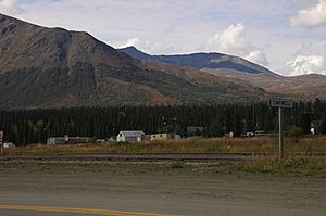
Town of Cantwell, Alaska. Tracks for the Alaska Railroad run through the foreground.
|
|

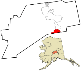
Location in Denali Borough and the state of Alaska.
|
|
| Country | United States |
| State | Alaska |
| Borough | Denali |
| Area | |
| • Total | 119.37 sq mi (309.16 km2) |
| • Land | 119.02 sq mi (308.26 km2) |
| • Water | 0.35 sq mi (0.91 km2) |
| Elevation | 2,190 ft (670 m) |
| Population
(2020)
|
|
| • Total | 200 |
| • Density | 1.68/sq mi (0.65/km2) |
| Time zone | UTC−09:00 (Alaska (AKST)) |
| • Summer (DST) | UTC−08:00 (AKDT) |
| ZIP Code |
99729
|
| Area code(s) | 907 |
| FIPS code | 02-10150 |
Cantwell is a small community in Denali Borough, Alaska, United States. It is also known as Yidateni Na’ in the Ahtna Athabascan language. In 2020, about 200 people lived here.
Cantwell is at the western end of the Denali Highway. It started as a stop along the Alaska Railroad. The town is located near the Parks Highway, an important road in Alaska.
Contents
History of Cantwell
Cantwell is named after Lieutenant J. C. Cantwell. He was a military explorer who commanded a ship on the Yukon River around 1900. Before the town was built, Tanana Indians and other Athabascan Native Alaskans lived in the area. They were nomadic, meaning they moved around to hunt and fish. They called this area Yede'teni'na.
How Cantwell Began
The town began as a "flag stop" on the Alaska Railroad. A flag stop is a place where a train only stops if someone waves a flag to get on, or if someone on the train wants to get off. This stop helped supply the Valdez Creek mining area. Many Native Alaskans from the village of Tyone came to work in the mines. Later, some of them settled in Cantwell. Many Tyone people are buried in the old Cantwell graveyard, which is next to the railroad tracks.
Oley Nicklie, a Native Alaskan, started working for the railroad when fur prices dropped. He and his two brothers helped found part of the settlement.
Cantwell in Movies
Cantwell has been a filming location for movies. In the 1920s, parts of Lure of the Yukon were filmed here. More recently, in 2007, the movie Into the Wild also used Cantwell as a location.
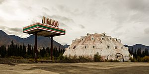
Cantwell is also known for a giant, abandoned hotel shaped like an igloo. It's about 20 miles away from the town.
Geography and Location
Cantwell is in the southern part of Denali Borough. It is located at the north end of Broad Pass. The town sits along Cantwell Creek and the Jack River. These rivers flow into the north-flowing Nenana River.
Getting to Cantwell
Alaska Route 3, also known as the George Parks Highway, goes through Cantwell. This highway connects major cities in Alaska. Anchorage is about 212 miles (341 km) south of Cantwell. Fairbanks is about 150 miles (241 km) north.
The Cantwell area covers about 119.37 square miles (309.16 square kilometers). Most of this area is land, with a small amount of water.
Climate in Cantwell
Cantwell has a continental subarctic climate. This means it has mild summers with cool nights. The winters are long, very cold, and get a lot of snow. For example, on a summer day in July 2003, 6 inches (15 cm) of snow fell in Cantwell!
| Climate data for Cantwell, Alaska, 1991–2020 normals, 1983-2020 extremes: 2132ft (650m) | |||||||||||||
|---|---|---|---|---|---|---|---|---|---|---|---|---|---|
| Month | Jan | Feb | Mar | Apr | May | Jun | Jul | Aug | Sep | Oct | Nov | Dec | Year |
| Record high °F (°C) | 44 (7) |
52 (11) |
58 (14) |
64 (18) |
78 (26) |
87 (31) |
85 (29) |
87 (31) |
71 (22) |
66 (19) |
48 (9) |
45 (7) |
87 (31) |
| Mean daily maximum °F (°C) | 9.9 (−12.3) |
19.0 (−7.2) |
25.4 (−3.7) |
39.5 (4.2) |
54.0 (12.2) |
65.0 (18.3) |
65.8 (18.8) |
60.6 (15.9) |
50.3 (10.2) |
33.7 (0.9) |
18.4 (−7.6) |
13.4 (−10.3) |
37.9 (3.3) |
| Daily mean °F (°C) | 0.7 (−17.4) |
7.7 (−13.5) |
11.7 (−11.3) |
27.7 (−2.4) |
41.5 (5.3) |
52.0 (11.1) |
55.2 (12.9) |
50.7 (10.4) |
40.7 (4.8) |
25.1 (−3.8) |
9.2 (−12.7) |
3.9 (−15.6) |
27.2 (−2.7) |
| Mean daily minimum °F (°C) | −8.6 (−22.6) |
−3.5 (−19.7) |
−1.9 (−18.8) |
15.9 (−8.9) |
29.1 (−1.6) |
38.9 (3.8) |
44.5 (6.9) |
40.8 (4.9) |
31.1 (−0.5) |
16.5 (−8.6) |
0.1 (−17.7) |
−5.7 (−20.9) |
16.4 (−8.6) |
| Record low °F (°C) | −49 (−45) |
−47 (−44) |
−45 (−43) |
−32 (−36) |
6 (−14) |
23 (−5) |
28 (−2) |
13 (−11) |
−11 (−24) |
−29 (−34) |
−36 (−38) |
−47 (−44) |
−49 (−45) |
| Average precipitation inches (mm) | 0.89 (23) |
0.86 (22) |
0.66 (17) |
0.47 (12) |
0.76 (19) |
1.59 (40) |
2.93 (74) |
3.32 (84) |
2.51 (64) |
1.23 (31) |
0.86 (22) |
0.74 (19) |
16.82 (427) |
| Average snowfall inches (cm) | 21.7 (55) |
15.4 (39) |
13.9 (35) |
10.6 (27) |
5.4 (14) |
0.2 (0.51) |
0.0 (0.0) |
0.0 (0.0) |
4.0 (10) |
15.9 (40) |
16.4 (42) |
21.7 (55) |
125.2 (317.51) |
| Source 1: NOAA (1981-2010 snowfall) | |||||||||||||
| Source 2: XMACIS2 (records) | |||||||||||||
Population of Cantwell
| Historical population | |||
|---|---|---|---|
| Census | Pop. | %± | |
| 1940 | 17 | — | |
| 1950 | 67 | 294.1% | |
| 1960 | 85 | 26.9% | |
| 1970 | 62 | −27.1% | |
| 1980 | 89 | 43.5% | |
| 1990 | 147 | 65.2% | |
| 2000 | 222 | 51.0% | |
| 2010 | 219 | −1.4% | |
| 2020 | 200 | −8.7% | |
| U.S. Decennial Census | |||
Cantwell first appeared in the U.S. Census in 1940 with only 17 people. Over the years, its population has changed, reaching 200 people in 2020.
Education
Students in Cantwell from kindergarten through 12th grade attend Cantwell School. This school is part of the Denali Borough School District.
See also
 In Spanish: Cantwell (Alaska) para niños
 | William M. Jackson |
 | Juan E. Gilbert |
 | Neil deGrasse Tyson |


