Cape Lisburne facts for kids
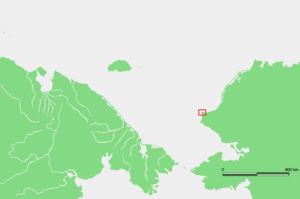
Cape Lisburne (called Uivvaq by the Iñupiaq people) is a special point of land in Alaska. It's located on the northwest tip of the Lisburne Peninsula, right on the Chukchi Sea coast. This cape is about 40 miles (64 km) northeast of a village called Point Hope. It's part of the Alaska Maritime National Wildlife Refuge, which protects wildlife. Cape Lisburne is the most northwestern piece of land in Alaska and all of North America. Because of the International Date Line, it's also one of the westernmost points in the world!
Contents
A Look Back in Time
How Cape Lisburne Got Its Name
The first European explorer to see this cape was James Cook. He discovered it on August 21, 1778. He decided to name it Cape Lisburne.
The Iñupiaq Name
The native Iñupiaq people had their own name for the cape: "Uivvaq". This name was often spelled "Wevok" or "Wevuk". They sometimes called it "Uivvaq Uŋasiktuq," which means "distant cape." This helped them tell it apart from "Uivvaq Qanittuq" (Cape Thompson), which means "near cape."
Challenges for the Community
Sadly, the native Iñupiaq people who lived there faced a very serious illness. Many people, including an Episcopal missionary named John Driggs, passed away during this time.
A Military Past
From 1951 to 1983, the United States Air Force had a special station at Cape Lisburne. This station used radar and communication tools. It was part of the DEW Line, a network of radar sites across the Alaska North Slope. Today, the Pacific Air Forces Regional Support Center still looks after the radar equipment there.
 | Chris Smalls |
 | Fred Hampton |
 | Ralph Abernathy |


