Carahue facts for kids
Quick facts for kids
Carahue
|
|||||
|---|---|---|---|---|---|

|
|||||
|
|||||
| Nickname(s):
"The three-floor city" ("La ciudad de los tres pisos")
|
|||||
| Country | Chile | ||||
| Region | Araucanía | ||||
| Province | Cautín | ||||
| Re-founded | 22 February 1882 | ||||
| Founded by | Gregorio Urrutia Venegas | ||||
| Government | |||||
| • Type | Municipality | ||||
| Area | |||||
| • Total | 1,340.5 km2 (517.6 sq mi) | ||||
| Elevation | 3 m (10 ft) | ||||
| Population
(2012 Census)
|
|||||
| • Total | 24,377 | ||||
| • Density | 18.1850/km2 (47.0989/sq mi) | ||||
| • Urban | 11,596 | ||||
| • Rural | 14,100 | ||||
| Sex | |||||
| • Men | 13,017 | ||||
| • Women | 12,679 | ||||
| Time zone | UTC−4 (CLT) | ||||
| • Summer (DST) | UTC−3 (CLST) | ||||
| Area code(s) | 56 + 45 | ||||
| Climate | Csb | ||||
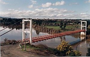
Carahue is a city and a commune (like a local district) in southern Chile. It is located about 56 kilometers (35 miles) west of Temuco. The city sits on the northern bank of the Imperial River.
Contents
History of Carahue
Carahue has a very old and interesting history. It was first founded on April 16, 1552. The famous Spanish explorer Pedro de Valdivia named it La Imperial.
Early Days and Destruction
La Imperial was an important Spanish settlement. However, it faced many challenges. In 1598, a big uprising by the Mapuche people began. This event is known as the Destruction of Seven Cities.
During this time, many Spanish cities were destroyed. La Imperial was abandoned and ruined in 1600. For a long time, it remained in ruins.
Refounding the City
The city was refounded much later, in 1882. This happened during a period called the Occupation of the Araucanía. The new city was given the name Carahue.
Nature and Environment
The commune of Carahue is special for its nature. It is home to some of the southernmost natural forests of Araucaria araucana trees. These unique trees are found in the Chilean Coast Range.
People and Population
Understanding the people of Carahue helps us learn about the city. A census is a count of all the people living in a place. It also gathers information about them.
Population Numbers
According to the 2002 census, Carahue covers an area of about 1,340.5 square kilometers (517.6 square miles). At that time, it had 25,696 people living there.
There were 13,017 men and 12,679 women counted. About 11,596 people (45.1%) lived in urban areas (cities and towns). The other 14,100 people (54.9%) lived in rural areas (the countryside).
Population Growth
Between the 1992 and 2002 censuses, the population of Carahue grew a little. It increased by 196 people, which is about 0.8%.
How Carahue is Governed
Carahue is a commune, which means it is a local administrative area in Chile. It is managed by a municipal council. This council helps make decisions for the community.
The Alcalde (Mayor)
The leader of the municipal council is called an alcalde. This is like a mayor. The alcalde is chosen directly by the people in an election every four years. The current alcalde of Carahue is Héctor Alejandro Sáez Veliz. He belongs to the UDI political party.
Local Representation
People in Carahue also have representatives in the national government. These representatives speak for the commune in the Chilean Parliament.
Chamber of Deputies
Carahue is part of an area that elects members to the Chamber of Deputies. This is similar to a House of Representatives.
Senate
The commune is also represented in the Senate of Chile. The Senate is the upper house of the Chilean Parliament.
See also
 In Spanish: Carahue para niños
 | Aaron Henry |
 | T. R. M. Howard |
 | Jesse Jackson |


