
Caravia facts for kids
Quick facts for kids
Caravia
|
||
|---|---|---|
|
||
 |
||

Caravia
Location in Spain
|
||
| Country | ||
| Autonomous community | ||
| Province | Asturias | |
| Comarca | Oriente | |
| Judicial district | Villaviciosa | |
| Capital | Prado | |
| Area | ||
| • Total | 13.36 km2 (5.16 sq mi) | |
| Highest elevation | 631 m (2,070 ft) | |
| Population
(2018)
|
||
| • Total | 477 | |
| • Density | 35.70/km2 (92.47/sq mi) | |
| Demonym(s) | caraviense | |
| Time zone | UTC+1 (CET) | |
| • Summer (DST) | UTC+2 (CEST) | |
| Postal code |
33344
|
|

Caravia is a small town, also called a municipality, in Asturias, Spain. It's on the northern coast, right next to the Bay of Biscay. To the south, it borders Parres, to the east Ribadesella, and to the west Colunga.
Contents
Exploring Caravia's Geography
Caravia is one of the smallest municipalities in Asturias. Most people live in its main towns: Prado (also called Prau in Asturian), Duesos, and Duyos. It's about 68 kilometers from Oviedo, the capital city.
Mountains and Beaches
In the southern part of Caravia, you'll find mountains. The highest point is Fito, which is 631 meters tall. Up north, there are three main beaches: Beciella, Arenal de Morís, and Espasa. Tall cliffs separate these beautiful beaches along the coast. The rest of Caravia is mostly flat. The main river flowing through the area is the Romeros river.
Caravia is also part of a special area called Sierra del Sueve. This area includes nearby towns like Colunga, Piloña, Parres, and Ribadesella.
Local Areas: Parishes
Caravia is divided into two smaller areas called parishes:
- Caravia Alta
- Caravia Baja
Caravia's Ancient History
People have lived in Caravia for a very long time! We know this from old discoveries.
Stone Age Discoveries
The first humans lived here during the Paleolithic period. This was a time when people started using stone tools. Near Duyos, there are old ruins called "Les Vaques" and "La Pongueta." These show where Paleolithic people lived near a small river and rocky cliffs.
Ancient Burial Mounds
Near Beciella beach, close to the Romeros river, there's a large dolmen-like tumulus. A tumulus is a mound of earth and stones built over a grave. Nearby, there's also the Necrópolis de la Tuerba. This is a burial ground with three more tumuluses on the coast.
Iron Age Fortification
In 1917, a person named Aurelio del Llano found an ancient fort called Picu el Castru. This fort was built on a hill, about two kilometers from the sea and 380 meters high. It was a great spot to watch over Caravia and Colunga.
The fort had walls that stretched for 225 meters. To get inside, you had to follow a winding path. Inside, there were foundations of rectangular huts, about 4 by 3 meters each.
Archaeologists found tools, cooking items, and jewelry there. They found brooches made of bronze and iron, along with necklaces. One special bronze brooch had a pony carved into it! Experts believe this fort dates back to the Bronze Age (from 2500 BC to 900 BC). All the items found are now kept at the Archaeological Museum of Asturias.
Roman Times in Caravia
An important stone carving from the Roman era was found in Caravia. It's called the Stele of Duesos (La Estela de Duesos). This stone was found outside the Church of Duesos.
Often, these ancient stones were built into Christian churches. This happened when old places of worship for different religions were changed into Christian sites. The Stele of Duesos is a piece of a larger stone. It has carvings on all four sides, with patterns that look like curved lines, similar to a swastika. It mixes Roman styles with older local designs. Some items from the ancient fort also have similar decorations.
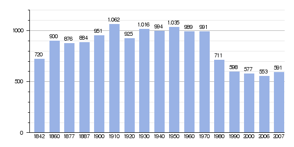
Caravia's Population Over Time
The number of people living in Caravia has changed a lot over the years. Here's a look at how the population has grown and shrunk:
 |
|
|
See also
 In Spanish: Caravia para niños
