Caribou Lake (Temagami) facts for kids
Quick facts for kids Caribou Lake |
|
|---|---|

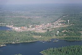
An aerial view of the Temagami townsite, Lake Temagami (centre-left) and Caribou Lake (bottom)
|
|
| Location | Temagami, Nipissing, Ontario |
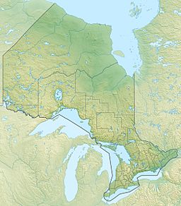
| Coordinates | 47°03′37″N 79°47′09″W / 47.06028°N 79.78583°W |
| Type | Lake |
| Part of | Ottawa River drainage basin |
| Max. length | 1.1 km (0.68 mi) |
| Max. width | 0.4 km (0.25 mi) |
| Surface elevation | 298 m (978 ft) |
Caribou Lake is a beautiful lake found in Northeastern Ontario, Canada. It is located in Strathy Township, which is part of the Nipissing District. The main town of Temagami is right on the north-northwestern side of the lake.
This lake is an important part of the Ottawa River drainage basin. This means its waters eventually flow into the Ottawa River, a major river in Canada.
Contents
Where Caribou Lake's Water Goes
The water from Caribou Lake flows out through a small, unnamed creek. This creek leads to Snake Island Lake. From there, the water travels through a series of other lakes and rivers.
The Water's Journey
- The water goes from Snake Island Lake to Cassels Lake.
- Next, it flows into Rabbit Lake.
- After Rabbit Lake, the water enters the Matabitchuan River.
- Finally, the Matabitchuan River carries the water into Lake Timiskaming.
- From Lake Timiskaming, the water joins the large Ottawa River.
Caribou Mountain: A Nearby Landmark
Rising high above Caribou Lake is Caribou Mountain. This is a large hill covered in trees. It's a very noticeable feature in the area.
The Fire Tower
On top of Caribou Mountain, there is a 30.4 m (100 ft) fire tower. This tower is used to spot forest fires from a distance. It helps protect the forests around the lake. The mountain itself rises about 122 m (400 ft) above the lake's surface.


