Carihuairazo facts for kids
Quick facts for kids Carihuairazo |
|
|---|---|

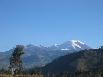
Carihuayrazo left of bigger Chimborazo as seen from the north
|
|
| Highest point | |
| Elevation | 5,018 m (16,463 ft) |
| Geography | |
| Parent range | Andes, Cordillera Occidental |
| Topo map | IGM, CT-ÑIV-C1 [1] |
| Geology | |
| Age of rock | Paleogene (Gomez 1994) |
| Mountain type | Stratovolcano |
| Last eruption | Unknown |
| Climbing | |
| First ascent | 1951 A. Eichler, H.L. Uribe, J. Morawiecki |
| Easiest route | glacier/snow/rock climb AD |
Mount Carihuairazo (also Carihuayrazo) is a tall mountain in Ecuador. It used to be a stratovolcano, which is a cone-shaped volcano made of many layers of hardened lava and ash. Today, it stands next to Chimborazo, Ecuador's highest mountain.
Contents
Geography
Where is Carihuairazo?
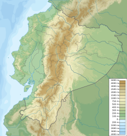
Carihuairazo is found in the Andes mountains of central Ecuador. This part of the Andes is called the Western Mountain Range. It is about 150 km (93 mi) south-southwest of Quito, the capital city.
Carihuairazo is close to the much taller Chimborazo, which is 6,263 meters (20,548 feet) high. The cities of Riobamba, Ambato, and Guaranda are all about 30 km (19 mi) away.
The top of Carihuairazo is a wide, eroded caldera. A caldera is a large bowl-shaped hollow that forms when the roof of a volcano's magma chamber collapses. This one opens towards the east.
Carihuairazo is part of a special area called the "Reserva de Produccion Faunistica Chimborazo" (Chimborazo Wildlife Production Reserve). This reserve helps protect the homes of native South American animals. These include Vicuñas, Llamas, and Alpacas, which are all types of camelids.
Carihuairazo's Glacier
Carihuairazo used to have a large glacier, which is a big mass of ice. However, this glacier has shrunk a lot in recent years. This is mainly due to global warming. Global warming means the Earth's average temperature is slowly getting warmer.
Ash from the nearby Tungurahua volcano has also covered the glacier. This dark ash makes the ice melt faster. Scientists expect Carihuairazo's glacier to completely disappear soon, possibly between 2020 and 2030.
Is Carihuairazo an active volcano?
Long ago, Carihuairazo was likely a huge volcano, similar in size to Chimborazo. But powerful explosions destroyed much of its peak. This left behind the caldera we see today.
There are no records of Carihuairazo erupting in modern history. Because of this, it is considered an inactive volcano. This means it is not expected to erupt again.
History
What does the name Carihuairazo mean?
The name Carihuairazo comes from the Quichua language. Some people believe it combines three words:
- Cari means "man."
- Huay means "wind."
- Razu means "ice" or "snow."
So, the name could mean "Man of Wind and Ice."
Local stories from the Indigenous people tell a different tale. They say that Carihuairazo and another volcano, El Altar, were both destroyed. This happened during a fight between Taita (Father) Chimborazo and these two mountains. They were fighting for the attention of Mama Tungurahua.
Who first climbed Carihuairazo?
The famous climber Edward Whymper and his team climbed Carihuairazo in 1880. His team included the cousins Louis and Jean-Antoine Carrel, and Ecuadorians David Beltran and Francisco Campaña.
It's not fully clear which peak they reached. Whymper wrote that they climbed in cloudy weather. They thought they had reached the Mocha peak (4,960m). But when the clouds cleared, they realized they had climbed a different peak. It's thought they reached the central summit, which is just west of Mocha.
Because of this confusion, the first confirmed climb of the highest point, the Maxim summit (5,018m), is given to others. Arturo Eichler, Horacio Lopez Uribe, and Jean Morawiecki reached the Maxim summit in 1951.
Climbing
Climbing Carihuairazo has become more challenging. This is because the glacier has melted. What used to be an easier glacier route with some rock climbing is now harder. It requires more technical climbing to reach the top.
- You can climb Carihuairazo almost any time of year.
- The best times are usually December to January and July to August.
- It's very important to get used to the high altitude before climbing. This is called acclimatization.
- You can find the mountain on a special map. It's called the Chimborazo (CT-ÑIV-C1) map from the IGM (Instituto Geografico Militar).
Climbing Routes
The most common way to climb Carihuairazo's highest point, Maxima (5,018m), starts from a camping spot. This spot is usually around 4,600m (15,092 feet) high.
Climbers then reach the main ridge. They can do this by following the southwest ridge. Or they can go from the west side, crossing the glacier. After reaching the ridge, there is a difficult technical climb to reach the very top.
See also
 In Spanish: Volcán Carihuairazo para niños
- Lists of volcanoes
- List of volcanoes in Ecuador
 | Jackie Robinson |
 | Jack Johnson |
 | Althea Gibson |
 | Arthur Ashe |
 | Muhammad Ali |


