
Carnuel, New Mexico facts for kids
Quick facts for kids
Carnuel, New Mexico
|
|
|---|---|

Old Mountain Lodge on Old Route 66
|
|

Location of Carnuel, New Mexico
|
|

Carnuel, New Mexico
Location in the United States
|
|
| Country | United States |
| State | New Mexico |
| County | Bernalillo |
| Area | |
| • Total | 5.35 sq mi (13.85 km2) |
| • Land | 5.32 sq mi (13.77 km2) |
| • Water | 0.03 sq mi (0.08 km2) |
| Elevation | 5,807 ft (1,770 m) |
| Population
(2020)
|
|
| • Total | 1,019 |
| • Density | 191.61/sq mi (73.98/km2) |
| Time zone | UTC-7 (Mountain (MST)) |
| • Summer (DST) | UTC-6 (MDT) |
| Area code(s) | 505 |
| FIPS code | 35-12430 |
| GNIS feature ID | 2407968 |
Carnuel is a small community in Bernalillo County, New Mexico, United States. It's known as a census-designated place (CDP), which means it's a community that isn't officially a city or town, but its population is counted by the government. In 2020, about 1,019 people lived there. Carnuel is part of the larger Albuquerque area.
Contents
What's in a Name?
The name Carnuel, sometimes spelled Carnué, might come from a Tiwa word. The Tiwa are a group of Native American people. Experts believe the name means "badger place." Local people who have lived there for a long time agree with this idea.
A Look at Carnuel's History
Carnuel, also known by its full name San Miguel de Loredo de Carnué, is located about 20 kilometers (12 miles) east of the original center of Albuquerque.
How Carnuel Started
The town was first created in 1763. Its main purpose was to help protect Albuquerque from attacks. These attacks came from Comanche, Kiowa, and Plains Apache Native American groups. Carnuel was built at the entrance of Tijeras Canyon. This canyon was a very important natural path. It connected the Great Plains, where some Native American groups lived, with the Spanish settlements in the Rio Grande valley.
The first settlers in Carnuel were 19 men, some with their families. Many of them were people who had mixed Spanish and Native American backgrounds. They were attracted to Carnuel because they could get land there. The New Mexican government gave them land grants, which meant they could own their own property.
Challenges and Rebuilding
In 1771, Apache raiders attacked the area. Several people were killed, and the remaining settlers had to leave the town.
However, Carnuel was settled again in 1819. The new settlers included descendants of the first families and other people who needed land. Twenty-two families received land in Carnuel. Another 22 families got land in San Antonio, a community about 10 kilometers (6 miles) northeast of Carnuel. By this time, the people of New Mexico had made peace with the Comanche. This made it safer to live on the eastern edges of the colony. Even today, the history of these land grants still affects how land and water are used in Carnuel. The nearby villages of Tijeras and Cedar Crest are also within the area of the original land grant.
Carnuel's Location and Climate

Carnuel covers an area of about 14.05 square kilometers (5.42 square miles). A very small part of this area, about 0.08 square kilometers (0.03 square miles), is water.
Weather in Carnuel
Carnuel has a climate similar to nearby Albuquerque. It's a steppe climate, which means it's usually dry. It has hot summers and cool winters. It's almost a desert climate. More than half of the yearly rain falls between July and August. On average, Carnuel gets about 9.5 inches (241 millimeters) of rain each year.
People of Carnuel
| Historical population | |||
|---|---|---|---|
| Census | Pop. | %± | |
| 2020 | 1,019 | — | |
| U.S. Decennial Census | |||
In 2000, there were 872 people living in Carnuel. There were 371 households, and 244 of these were families. The population density was about 354 people per square mile (136 people per square kilometer).
Most of the people in Carnuel identified as White (69.27%). About 27.06% identified as being from other races. A small number identified as African American (0.34%) or Native American (1.72%). About 51.15% of the population identified as Hispanic or Latino.
Households and Families
Out of the 371 households:
- 25.1% had children under 18 living with them.
- 50.4% were married couples living together.
- 8.9% had a female head of household with no husband present.
- 34.0% were not families.
- 29.1% of all households were single individuals.
- 10.2% had someone living alone who was 65 years old or older.
The average household had 2.32 people, and the average family had 2.83 people.
Age Groups
The population in Carnuel was spread out by age:
- 20.9% were under 18 years old.
- 6.1% were between 18 and 24 years old.
- 27.3% were between 25 and 44 years old.
- 30.3% were between 45 and 64 years old.
- 15.5% were 65 years old or older.
The average age of people in Carnuel was 42 years. For every 100 females, there were about 106.1 males.
Income and Poverty
In 2000, the average income for a household in Carnuel was $37,813 per year. For families, the average income was $46,250 per year. Men generally earned more than women. The average income per person in Carnuel was $18,553. About 9.2% of families and 12.3% of the total population lived below the poverty line. This included 11.6% of those under 18 and 12.6% of those 65 or older.
Education
Students in Carnuel attend schools that are part of Albuquerque Public Schools.
Images for kids
-
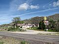
Old Mountain Lodge on Old Route 66
-
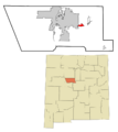
Location of Carnuel, New Mexico
See also
 In Spanish: Carnuel (Nuevo México) para niños
