Tijeras, New Mexico facts for kids
Quick facts for kids
Tijeras, New Mexico
|
|
|---|---|
|
Village
|
|

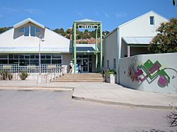
East Mountain Library in Tijeras
|
|

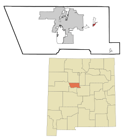
Location of Tijeras, New Mexico
|
|
| Country | United States |
| State | New Mexico |
| County | Bernalillo |
| Area | |
| • Total | 1.14 sq mi (2.95 km2) |
| • Land | 1.13 sq mi (2.93 km2) |
| • Water | 0.01 sq mi (0.01 km2) |
| Elevation | 6,382 ft (1,945 m) |
| Population
(2020)
|
|
| • Total | 465 |
| • Density | 410.78/sq mi (158.59/km2) |
| Time zone | UTC-7 (Mountain (MST)) |
| • Summer (DST) | UTC-6 (MDT) |
| ZIP code |
87059
|
| Area code(s) | 505 |
| FIPS code | 35-77880 |
| GNIS feature ID | 2413593 |
Tijeras is a small village located in Bernalillo County, New Mexico, United States. In 2020, about 465 people lived there. It is part of the larger Albuquerque metropolitan area, which means it's near the city of Albuquerque.
Contents
Ancient History of Tijeras
The Tijeras Pueblo Archaeological Site is an important historical place in Tijeras. It's where Ancestral Pueblo people lived a long time ago, from about 1313 CE (Common Era) to 1425 CE.
When it was first built, the Tijeras Pueblo had around 200 rooms. These rooms were in buildings that looked like a "U" shape, with a large ceremonial room called a Kiva in the middle. The pueblo was partly left empty after 1360. However, people started rebuilding around 1390, though it never became as big as it was before. By 1425, the pueblo was completely abandoned. No one knows for sure why they left, but it might have been because of dry weather and not enough water.
Today, you can visit the Tijeras Pueblo Archaeological Site. There's a museum that's open on weekends, and a path you can follow to explore the old ruins.
Village History
Tijeras was once part of a special area called the Carnuel land grant. This land grant was created in 1763 to help protect Albuquerque from attacks by Native American groups like the Comanche, Kiowa, and Plains Apache.
The village is located in Tijeras Canyon. This canyon was a natural pathway between the nomadic (traveling) Native American groups from the Great Plains and the Spanish settlements in the Rio Grande valley. The first settlers in Carnuel were about nineteen men, some with families. Many of them were from lower social groups in Spanish society, including "coyotes" (people of mixed heritage) and genizaros (Native Americans who lived among the Spanish and adopted some of their culture). For these settlers, the chance to own land through the land grant was a big reason to move to the Tijeras area.
In 1771, Apache raiders attacked the area, and the people who survived had to leave the land grant. The Mescalero Apache name for Tijeras canyon is Nakai'e Naagishuł, which means "Mexican they dragged."
The Tijeras area was settled again in 1819 by the children and grandchildren of the first settlers, along with other people who didn't own land. By this time, New Mexico had made peace with the Comanche, so it was safer to live there. The traditions of the genizaro people continued to influence how land and water were used in the Carnuel land grant even into the 21st century.
Where is Tijeras?
Location and Roads
Tijeras is in central New Mexico. It's about 25 kilometers (15 miles) east of Albuquerque. You can reach it by taking Interstate 40 (Exit 175) or U.S. Highway 66 (Route 66)/New Mexico state highway 333.
New Mexico State Road 14 goes north from the village towards places like Cedar Crest, Sandia Crest, Madrid, and Santa Fe. New Mexico State Road 337 goes south from Tijeras (you can see it on a Google map).
Natural Features
Tijeras is located where Tijeras Canyon meets Cedro Canyon. Tijeras Canyon leads west towards Albuquerque, and Cedro Canyon leads south towards the Manzano Mountains.
Land and Water
The village of Tijeras covers a total area of about 3.0 square kilometers (1.14 square miles). Most of this is land, with only a very small part (about 0.02 square kilometers or 0.01 square miles) being water.
Climate
| Climate data for Tijeras, NM | |||||||||||||
|---|---|---|---|---|---|---|---|---|---|---|---|---|---|
| Month | Jan | Feb | Mar | Apr | May | Jun | Jul | Aug | Sep | Oct | Nov | Dec | Year |
| Mean daily maximum °F (°C) | 43.7 (6.5) |
48.5 (9.2) |
54.7 (12.6) |
63.6 (17.6) |
74.5 (23.6) |
84.6 (29.2) |
86.0 (30.0) |
83.7 (28.7) |
77.7 (25.4) |
66.8 (19.3) |
53.6 (12.0) |
44.1 (6.7) |
65.1 (18.4) |
| Mean daily minimum °F (°C) | 20.8 (−6.2) |
24.1 (−4.4) |
28.9 (−1.7) |
34.0 (1.1) |
43.2 (6.2) |
51.8 (11.0) |
56.3 (13.5) |
55.2 (12.9) |
47.7 (8.7) |
37.3 (2.9) |
27.4 (−2.6) |
20.9 (−6.2) |
37.3 (2.9) |
| Average precipitation inches (mm) | 1.0 (25) |
0.9 (23) |
1.2 (30) |
1.0 (25) |
1.0 (25) |
0.8 (20) |
2.8 (71) |
2.5 (64) |
1.7 (43) |
1.4 (36) |
1.1 (28) |
1.2 (30) |
16.6 (420) |
| Average snowfall inches (cm) | 8.4 (21) |
6.8 (17) |
9.1 (23) |
3.0 (7.6) |
0.1 (0.25) |
0.0 (0.0) |
0.0 (0.0) |
0.0 (0.0) |
0.0 (0.0) |
0.0 (0.0) |
5.3 (13) |
9.3 (24) |
42 (105.85) |
| Source: Bestplaces | |||||||||||||
People of Tijeras
| Historical population | |||
|---|---|---|---|
| Census | Pop. | %± | |
| 1980 | 311 | — | |
| 1990 | 340 | 9.3% | |
| 2000 | 474 | 39.4% | |
| 2010 | 541 | 14.1% | |
| 2020 | 465 | −14.0% | |
| U.S. Decennial Census | |||
In 2000, there were 474 people living in Tijeras. About 65.82% of the people were White, and 28.06% were from other races. Many people, 56.33%, identified as Hispanic or Latino.
There were 191 households in the village. About 33.5% of these households had children under 18 living with them. The average household had about 2.48 people.
The median age (middle age) of people in the village was 39 years old. This means half the people were younger than 39, and half were older.
In 2009, the average household income in Tijeras was about $49,441. The average price for a home was around $229,479.
Education in Tijeras
Schools in Tijeras are part of the Albuquerque Public Schools system.
Special Features of Tijeras
The Musical Highway
In October 2014, Tijeras became famous for something unique: a "musical road" nearby. This is a two-lane part of an old highway (Route 66). It has special grooves in the road, called rumble strips. When cars drive over these grooves at 45 miles per hour, they create the sounds of the famous song "America the Beautiful"!
See also
 In Spanish: Tijeras (Nuevo México) para niños
 | Toni Morrison |
 | Barack Obama |
 | Martin Luther King Jr. |
 | Ralph Bunche |


