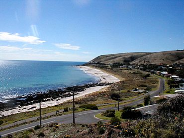
Carrickalinga facts for kids
Quick facts for kids CarrickalingaSouth Australia |
|||||||||||||||
|---|---|---|---|---|---|---|---|---|---|---|---|---|---|---|---|

North Carrickalinga Beach
|
|||||||||||||||
| Population | 364 (2016 census) | ||||||||||||||
| Established | 1958 | ||||||||||||||
| Postcode(s) | 5204 | ||||||||||||||
| Location | 61 km (38 mi) South of Adelaide | ||||||||||||||
| LGA(s) | District Council of Yankalilla | ||||||||||||||
| Region | Fleurieu and Kangaroo Island | ||||||||||||||
| State electorate(s) | Mawson | ||||||||||||||
| Federal Division(s) | Mayo | ||||||||||||||
|
|||||||||||||||
| Footnotes | Location Adjoining localities |
||||||||||||||
Carrickalinga is a small coastal town in South Australia. It is about 60 kilometres south of Adelaide. The town is located on the Fleurieu Peninsula, looking out over Gulf St Vincent.
The name Carrickalinga comes from the Kaurna language. The Kaurna people are the traditional owners of this land. There are no shops in Carrickalinga itself. The closest shops are in Normanville, which is only one kilometre away.
Haycock Point is a special place that separates two beaches. These are often called North Carrickalinga and South Carrickalinga beaches. Both beaches are part of Yankalilla Bay. Carrickalinga Creek is a small creek that flows into the sea south of the town.
Contents
History of Carrickalinga
Aboriginal History
Before European settlers arrived, the Kaurna people lived on this land. Their traditional country included the Adelaide plains and the western side of the Fleurieu Peninsula. The Kaurna name for this area was Karrakardlangga. Some believe this name means "place for redgum firewood."
An important story for the Kaurna people is the Tjilbruke Dreaming Track. This track follows the coastline through Carrickalinga. It tells the story of Tjilbruke, a creator ancestor. You can find a special commemorative plaque about this story on Gold Coast Drive, near the beach.
European Settlement
Carrickalinga first became known as a town in 1958. It started as a private subdivision of land. A man named George Lewis developed this area. The name "Carrickalinga" was chosen instead of "Gold Coast."
Over time, the boundaries of Carrickalinga were officially set. This happened under the Geographical Names Act 1988. Some changes to the boundaries were made in 1994 and again in 1999.
George Lewis is remembered in the name of Lewis Road. Another important person was Tom Lyddon, who worked for the District Council of Yankalilla. Lyddon Place is named after him. The first sales agent, Cliff Hawkins, put a flagpole on a hill near Solitude Drive. This flagpole is still there today.
How Carrickalinga is Governed
Carrickalinga is part of different government areas. For national elections, it is in the federal division of Mayo. For state elections, it is in the electoral district of Mawson. Locally, it is managed by the District Council of Yankalilla.
About the Beaches
The beaches in Carrickalinga are wide and have beautiful white sand. The sand stretches down to the clear water. Haycock Point divides the two main beaches. The beach north of the point is called Carrickalinga Beach by Beachsafe.
Carrickalinga Creek flows into the sea just south of Riverview Drive. Sometimes, the sand on the beach covers the mouth of the creek.
 | William M. Jackson |
 | Juan E. Gilbert |
 | Neil deGrasse Tyson |


