Yankalilla, South Australia facts for kids
Quick facts for kids YankalillaSouth Australia |
|||||||||
|---|---|---|---|---|---|---|---|---|---|

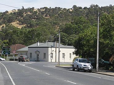
Main Road, Yankalilla
|
|||||||||
| Established | 1842 | ||||||||
| Postcode(s) | 5203 | ||||||||
| Area | 2.7 km2 (1.0 sq mi) | ||||||||
| Location | 72 km (45 mi) South of Adelaide via |
||||||||
| LGA(s) | District Council of Yankalilla | ||||||||
| Region | Fleurieu and Kangaroo Island | ||||||||
| State electorate(s) | Mawson | ||||||||
| Federal Division(s) | Mayo | ||||||||
|
|||||||||
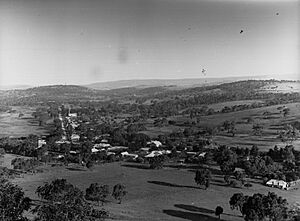
Yankalilla is a small town in South Australia, about 72 kilometers (45 miles) south of Adelaide, the state's capital city. It's located on the beautiful Fleurieu Peninsula, nestled in the valley of the Bungala River. The town is surrounded by the southern Mount Lofty Ranges.
Yankalilla is a service center for the farms and agricultural areas around it. In the past, it was a very important place for the early settlers of South Australia. However, with faster ways to travel and its closeness to Adelaide, its importance has changed over time.
Contents
What's in a Name? The Story of Yankalilla
The exact meaning of the name "Yankalilla" isn't fully clear, but it comes from the Kaurna Aboriginal language. In 1837, Governor Hindmarsh wrote down the Kaurna pronunciation as "Yoongalilla."
One popular idea is that the name comes from the Aboriginal word jankalan, which means "falling." This relates to a very old story from the Dreaming about a creator being named Tjilbruke. In this story, Tjilbruke was carrying his dead nephew's body, and it started to fall apart or "disintegrate" near this area.
Another idea, from Kaurna scholar Georgina Yambo Williams, suggests "Yankalilla" means "place of the fallen bits." This also connects to the Tjilbruke story, where his nephew's body began to break apart, and Tjilbruke collapsed. Some research even points to Lady Bay as the original spot for this event.
A Look Back in Time: Yankalilla's History
Ancient History: The Kaurna People
Long before European settlers arrived, the Yankalilla area was home to the Kaurna people. They were an Aboriginal Australian group who lived on the western side of the Fleurieu Peninsula, all the way up to Gulf St Vincent. The Kaurna people sometimes met with the Ramindjeri people from the Encounter Bay area to trade goods and share ideas.
The Kaurna people have many traditional stories that explain how the land was formed. One important story tells of Tjilbruke, a powerful ancestor. He created many of the landforms on the Fleurieu Peninsula as he traveled, grieving and carrying his nephew's body from the Sturt River to Cape Jervis.
European Settlement and Growth
Europeans began settling in the Yankalilla district very early in South Australia's history, starting in the late 1830s. In 1838, a large area of land around Yankalilla was measured out for sheep and dairy farming. The town itself was officially started in 1842.
One of the first settlers was Reverend Father Henry Kemmis, who moved to land given to him by his cousin, Governor George Grey. Soon after, in 1842, other settlers like Septimane Herbert and George Worthington built homes. Farmers started growing wheat and barley, which helped the area grow into an important farming region.
Yankalilla grew quickly between 1850 and 1870. During this time, it became one of the five most important towns in the colony of South Australia. A jetty (a pier) was built on the coast so that wheat grown in the area could be shipped out. The local government, called the district council, was officially formed in 1854. By the late 1860s, Yankalilla and nearby Normanville had many businesses, including flour mills, stores, breweries, blacksmiths, hotels, and churches.
Special Places in Town
The town's Anglican church, called 'Christ Church', has a very old and interesting font (a basin used for baptisms). This marble font actually came from Salisbury Cathedral in England, dating back to the Middle Ages. It was given to a former church leader in Yankalilla.
Another special spot is the Shrine of Our Lady of Yankalilla inside the Anglican church. In 1994, people believed an image of the Virgin Mary appeared on a wall behind the altar. It looked like her face and body, holding the crucified Christ, similar to a pietà. This story brought many visitors and tourists to the town.
Several buildings in Yankalilla are considered important historical sites, including the Anglican church, Manor Farm, and The Olives.
The Land Around Yankalilla
Yankalilla is located inland on the Fleurieu Peninsula, a piece of land that sticks out south of the Adelaide Plains. It sits in a valley created by the Bungala River, which flows into the sea near Normanville. The natural plants in the area are mostly Eucalypt trees and other native plants from southern Australia.
How the Land Was Formed
Most of the land in this region is made of sedimentary rock, which means it was formed from layers of sand, mud, and other materials that settled on an ancient sea floor. These rocks, like sandstone, mudstone, and limestone, were laid down between 1000 million and 600 million years ago.
The youngest rocks in the area are from the Cambrian period (600 to 500 million years ago). This was a time when the first fossils started appearing in the rock record. Fossils found near Normanville were the first proof of Cambrian-age rocks in the Mount Lofty Ranges.
The landscape we see today was shaped about two million years ago. This happened after the land sank down for a while, and then lifted up again due to movements deep within the Earth. These same movements also formed the Flinders Ranges.
Weather in Yankalilla
Yankalilla has a warm-summer Mediterranean climate. This means it has warm, dry summers and cool, rainy winters. Because it's close to the Southern Ocean, it's usually cooler and wetter than Adelaide.
The hottest month is January, with average high temperatures around 23.7°C (74.7°F). The coolest month is July, with average highs around 11.7°C (53.1°F). The town gets a moderate amount of rain each year, averaging about 816.6 millimeters (32.1 inches).
| Climate data for Yankalilla (35º34'48"S, 138º17'24"E, 341 m AMSL) (1994-2024 normals and extremes) | |||||||||||||
|---|---|---|---|---|---|---|---|---|---|---|---|---|---|
| Month | Jan | Feb | Mar | Apr | May | Jun | Jul | Aug | Sep | Oct | Nov | Dec | Year |
| Record high °C (°F) | 43.5 (110.3) |
40.2 (104.4) |
38.2 (100.8) |
32.9 (91.2) |
25.7 (78.3) |
21.6 (70.9) |
18.7 (65.7) |
21.7 (71.1) |
27.3 (81.1) |
33.6 (92.5) |
38.4 (101.1) |
40.3 (104.5) |
43.5 (110.3) |
| Mean daily maximum °C (°F) | 23.7 (74.7) |
23.2 (73.8) |
21.3 (70.3) |
18.3 (64.9) |
14.9 (58.8) |
12.4 (54.3) |
11.7 (53.1) |
12.5 (54.5) |
14.7 (58.5) |
16.9 (62.4) |
19.4 (66.9) |
21.7 (71.1) |
17.6 (63.6) |
| Mean daily minimum °C (°F) | 13.9 (57.0) |
13.9 (57.0) |
13.0 (55.4) |
11.3 (52.3) |
9.6 (49.3) |
7.8 (46.0) |
7.0 (44.6) |
7.1 (44.8) |
8.0 (46.4) |
9.0 (48.2) |
10.7 (51.3) |
12.0 (53.6) |
10.3 (50.5) |
| Record low °C (°F) | 7.6 (45.7) |
7.9 (46.2) |
6.3 (43.3) |
4.5 (40.1) |
1.8 (35.2) |
1.4 (34.5) |
1.2 (34.2) |
2.1 (35.8) |
1.7 (35.1) |
2.9 (37.2) |
4.4 (39.9) |
4.9 (40.8) |
1.2 (34.2) |
| Average precipitation mm (inches) | 29.6 (1.17) |
29.2 (1.15) |
32.0 (1.26) |
55.4 (2.18) |
95.9 (3.78) |
126.3 (4.97) |
123.5 (4.86) |
100.7 (3.96) |
79.8 (3.14) |
60.7 (2.39) |
43.7 (1.72) |
36.0 (1.42) |
816.6 (32.15) |
| Average precipitation days (≥ 0.2 mm) | 7.6 | 7.6 | 10.1 | 14.0 | 18.8 | 19.7 | 20.3 | 20.8 | 17.2 | 14.5 | 12.5 | 10.7 | 173.8 |
| Average afternoon relative humidity (%) | 58 | 59 | 61 | 67 | 76 | 82 | 82 | 77 | 73 | 68 | 66 | 60 | 69 |
| Average dew point °C (°F) | 10.8 (51.4) |
11.4 (52.5) |
10.2 (50.4) |
9.2 (48.6) |
9.1 (48.4) |
8.0 (46.4) |
7.3 (45.1) |
7.1 (44.8) |
7.7 (45.9) |
7.8 (46.0) |
9.7 (49.5) |
9.7 (49.5) |
9.0 (48.2) |
| Source: Bureau of Meteorology (1994-2024 normals and extremes) | |||||||||||||
Yankalilla's Economy: How the Town Makes a Living
The economy of Yankalilla mainly relies on the farms and agricultural land around it. However, other industries and tourism also help the town's economy.
Since it was founded, Yankalilla has been important for growing cereal crops like wheat and barley. This is still a big part of its agriculture today. Dairy farming and raising livestock, such as sheep and cattle, have also become very important. Dairy products are some of the town's biggest exports.
Tourism is growing quickly in Yankalilla. Many tourists visit the town each year, drawn by the church shrine and the peaceful country atmosphere. Others simply pass through while exploring the region.
Life in Yankalilla: Community and Activities
Yankalilla has many facilities and groups for its community, including health services, schools, and sports clubs. There are also several festivals throughout the year.
The Southern Fleurieu Health Service provides health care for the town, though there isn't a hospital directly in Yankalilla. The Yankalilla Area School teaches students from Reception (the first year of school) all the way through Year 12. There's also a public library where you can borrow books for free.
If you like sports, Yankalilla has many clubs and facilities! You can find teams for bowls, football (the Yankalilla Football Club), netball, cricket, hockey, and tennis. There's also a golf club, a gym, and a skate park in town.
Many environmental groups are active in the area, with some based in Yankalilla. These groups often work to restore the land to its natural state. They focus on things like animal conservation, monitoring rivers, and improving soil health.
Several fun events happen every year, including the Yankalilla Agricultural show, the Easter Art Show, and the New Year's Eve Pageant.
The local news is shared through The Yankalilla News, a free monthly magazine. It covers news about the Fleurieu Peninsula and is delivered to over 4,500 homes in the district.
Who Lives in Yankalilla?
According to the 2001 census, Yankalilla had a population of 440 people, with almost an equal number of males and females.
Most people (343) in the town were born in Australia. About 85 people had moved there from other countries. Most of these immigrants (75%) came from the United Kingdom, with smaller numbers from other European and Southeast Asian countries.
The census also found that Christianity was the most common religion, with 59% of people identifying as Christian. The main Christian groups were Anglican, Lutheran, and Catholic. About 25% of people said they had no religious beliefs.
Getting Around Yankalilla
You can reach Yankalilla and its surrounding areas by driving south from Adelaide along Main South Road. Another option is to take the Victor Harbor Road, though this route takes a bit longer.
Sealink buses also provide transport services to Yankalilla.
Nearby Towns
| North: Carrickalinga & Myponga | ||
| West: Normanville | Yankalilla | East: Wattle Flat & Torrens Vale Inman Valley |
| South: Hay Flat, Wirrina Cove, Parawa, Second Valley & Rapid Bay |
 | Georgia Louise Harris Brown |
 | Julian Abele |
 | Norma Merrick Sklarek |
 | William Sidney Pittman |


