
Inman Valley, South Australia facts for kids
Quick facts for kids Inman ValleySouth Australia |
|||||||||||||||
|---|---|---|---|---|---|---|---|---|---|---|---|---|---|---|---|

Glaciated pavement in the Inman River
|
|||||||||||||||

Inman Valley
Location in South Australia
|
|||||||||||||||
| Population | 343 (2016 census) | ||||||||||||||
| Postcode(s) | 5211 | ||||||||||||||
| Location | 86 km (53 mi) South of Adelaide | ||||||||||||||
| LGA(s) |
|
||||||||||||||
| Region | Fleurieu and Kangaroo Island | ||||||||||||||
| County | Hindmarsh | ||||||||||||||
| State electorate(s) | Finniss Mawson |
||||||||||||||
| Federal Division(s) | Mayo | ||||||||||||||
|
|||||||||||||||
|
|||||||||||||||
| Footnotes | Adloining localities | ||||||||||||||
Inman Valley is a small town in South Australia, located on the beautiful Fleurieu Peninsula. It's about 86 kilometers (about 53 miles) south of Adelaide, the capital city. The valley itself covers an area of about 380 square kilometers (about 147 square miles). In 2016, about 343 people lived in Inman Valley.
Contents
Why is it called Inman Valley?
Inman Valley and the Inman River are named after Inspector Henry Inman. He was the first leader of the South Australia Police. In August 1838, he chased two people he thought were escaped convicts into this valley.
The local Aboriginal people had their own names for the river. Two names recorded are Moo-oola and Moogoora. The river's mouth was called Mugurank, which means 'place of hammerstones'.
A Look at Inman Valley's Past

The first Europeans to likely see the valley were explorers in 1831. Back then, the valley was full of kangaroos. Early sealers and whalers from Encounter Bay would hunt them for food.
In late 1839, surveyors mapped out the valley. They marked sections of land and planned a road from Rapid Bay to Encounter Bay. This road is now known as Inman Valley Road.
Early Settlers Arrive
Soon after the surveys, land became available. In early 1840, the first European settlers arrived. These were three young brothers: William Rhodes James, John Vidal James, and Richard Boucher James. They worked hard to set up their home. They even made a shortcut, called James Track, to their land.
Richard Boucher James later bought a huge property called Canowie Station in 1858. He lived there for a few years before moving back to England. Even from England, he continued to manage the Canowie Pastoral Company until he passed away in 1908.
Other early settlers also came to Inman Valley around the same time. These included brothers Thomas Bewes Strangways and Giles Edward Strangways. Their land was closer to the mouth of the valley. Soon, more people like William Robinson and John Lush joined them. William Robinson was the first to drive a horse and cart over Mount Terrible.
Farming and Today's Land Use
At first, various crops grew well, and sheep farming was successful. However, cattle were found to do especially well in Inman Valley. Because of this, cattle farming became very popular. By the 1880s, a large dairy industry grew, producing butter and cheese. A butter factory was even built in 1890.
Today, the land in Inman Valley is mostly used for grazing animals, dairy farming, growing trees for wood (forestry), and growing fruits and vegetables (horticulture). The valley is also a great place for people who enjoy bushwalking and visiting nature.
Selwyn Rock: A Glimpse into the Ice Age
In Inman Valley, you can find a special place called Selwyn Rock (35°29′47″S 138°30′45″E / 35.4965°S 138.5124°E). It's a glaciated pavement in the Inman River bed. This means it's a smooth rock surface that was carved by ancient glaciers.
It was first described in 1859 by a geologist named A.R.C. Selwyn, and the rock was later named after him. You can see grooves and scratches on the polished rock surface. These marks show that the glaciers moved towards the north-west a very long time ago.
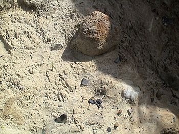
You can also find large rocks called erratics in the area. These rocks were carried by the glaciers from far away. The area was covered by ice during the Permian period, about 270 million years ago! The river later wore away the land, revealing this ancient rock surface. There's even a cafe overlooking the glaciated riverbed, with stairs and viewing platforms to help you see the rock up close.
Images for kids
-
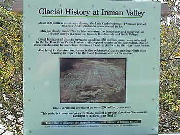
Interpretive sign at Selwyn Rock marking Selwyn's discovery of glaciation in Australia
-
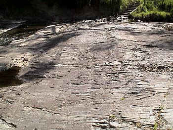
Selwyn Rock – grooves and striations on exhumed Permian glacial pavement
-
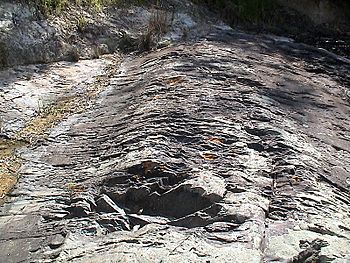
Selwyn Rock – grooves and striations on exhumed Permian glacial pavement
-
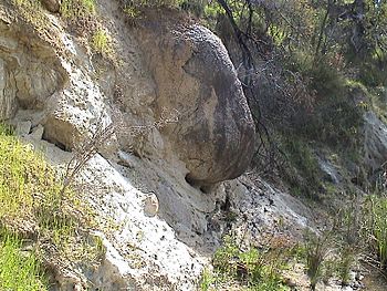
Selwyn Rock – granite glacial erratic eroding out of unconsolidated Permian till
-
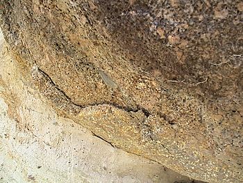
Selwyn Rock – Weathering rind of large granite glacial erratic eroding out of unconsolidated Permian till
-
Selwyn Rock – faceted pebble eroding out of unconsolidated Permian till


