Myponga, South Australia facts for kids
Quick facts for kids MypongaSouth Australia |
|||||||||||||||
|---|---|---|---|---|---|---|---|---|---|---|---|---|---|---|---|

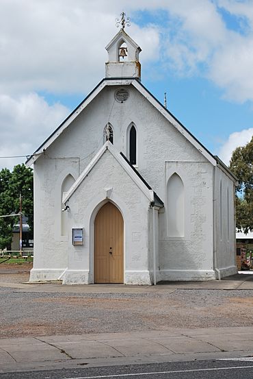
Anglican church
|
|||||||||||||||
| Population |
|
||||||||||||||
| Established | 1858 (sub-division) 5 August 1999 (locality) |
||||||||||||||
| Postcode(s) | 5202 | ||||||||||||||
| Elevation | 216 m (709 ft)(weather station) | ||||||||||||||
| Time zone | ACST (UTC+9:30) | ||||||||||||||
| • Summer (DST) | ACST (UTC+10:30) | ||||||||||||||
| Location |
|
||||||||||||||
| LGA(s) | District Council of Yankalilla | ||||||||||||||
| Region | Fleurieu and Kangaroo Island | ||||||||||||||
| County | Hindmarsh | ||||||||||||||
| State electorate(s) | Mawson | ||||||||||||||
| Federal Division(s) | Mayo | ||||||||||||||
|
|||||||||||||||
|
|||||||||||||||
| Footnotes | Adjoining localities | ||||||||||||||
Myponga is a small town in South Australia. It is located on the beautiful Fleurieu Peninsula. In 2016, about 744 people lived in the Myponga area. Of these, 393 lived right in the town centre. Myponga is part of the District Council of Yankalilla local government area.
Contents
History of Myponga
First People and Early Names
Before Europeans arrived in South Australia, the Kaurna people lived on the land. Their traditional lands included the area where Myponga is today. The Kaurna name for this place was Maitpungga.
Some people thought Maitpungga meant "divorced wife" or "vegetable food place". However, experts like linguist Rob Amery and Kaurna educator Jack Buckskin believe it is simply a name without a direct translation.
Settlement and Town Growth
One of the first European families to settle here was the Polden family around 1840. Myponga officially started as a settlement in 1858. This happened when people began buying land in a part of the Hundred of Myponga.
Later, in 1939, a new plan for the town was made. The official boundaries for the Myponga area were set on August 5, 1999.
Myponga Pop Festival
On January 31, 1971, Myponga became famous for a big music event. It was called the Myponga Open Air Festival. Two very popular bands played there: Daddy Cool and Black Sabbath. This was the first time Black Sabbath ever played live in Australia! About 15,000 people came to enjoy the music.
Myponga Weather Station
Myponga has had an official weather station since 1914. This station helps scientists track the weather and climate in the area.
| Climate data for Myponga, South Australia | |||||||||||||
|---|---|---|---|---|---|---|---|---|---|---|---|---|---|
| Month | Jan | Feb | Mar | Apr | May | Jun | Jul | Aug | Sep | Oct | Nov | Dec | Year |
| Mean daily maximum °C (°F) | 26.9 (80.4) |
25.8 (78.4) |
23.9 (75.0) |
20.4 (68.7) |
16.1 (61.0) |
14.0 (57.2) |
12.6 (54.7) |
13.5 (56.3) |
15.9 (60.6) |
18.6 (65.5) |
21.7 (71.1) |
23.6 (74.5) |
19.4 (66.9) |
| Mean daily minimum °C (°F) | 11.6 (52.9) |
11.8 (53.2) |
9.8 (49.6) |
7.5 (45.5) |
6.4 (43.5) |
4.6 (40.3) |
4.3 (39.7) |
4.6 (40.3) |
5.3 (41.5) |
6.6 (43.9) |
8.2 (46.8) |
9.8 (49.6) |
7.5 (45.5) |
| Average rainfall mm (inches) | 23.6 (0.93) |
27.4 (1.08) |
24.3 (0.96) |
55.4 (2.18) |
93.4 (3.68) |
112.3 (4.42) |
115.9 (4.56) |
97.3 (3.83) |
83.4 (3.28) |
58.5 (2.30) |
38.0 (1.50) |
31.4 (1.24) |
756.3 (29.78) |
| Average rainy days | 2.8 | 2.9 | 3.5 | 7 | 10.8 | 12.1 | 13.5 | 12.9 | 10.2 | 8.1 | 5.5 | 4.3 | 93.6 |
 | William Lucy |
 | Charles Hayes |
 | Cleveland Robinson |


