Myponga Beach, South Australia facts for kids
Quick facts for kids Myponga BeachSouth Australia |
|||||||||||||||
|---|---|---|---|---|---|---|---|---|---|---|---|---|---|---|---|

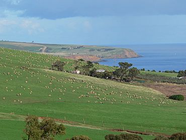
Sheep grazing on the slopes of Black Hill near Myponga Beach
|
|||||||||||||||
| Population | 33 (2016 census) | ||||||||||||||
| Established | 5 August 1999 | ||||||||||||||
| Postcode(s) | 5202 | ||||||||||||||
| Time zone | ACST (UTC+9:30) | ||||||||||||||
| • Summer (DST) | ACST (UTC+10:30) | ||||||||||||||
| Location | 54 km (34 mi) S of Adelaide | ||||||||||||||
| LGA(s) | District Council of Yankalilla | ||||||||||||||
| Region | Fleurieu and Kangaroo Island | ||||||||||||||
| State electorate(s) | Mawson | ||||||||||||||
| Federal Division(s) | Mayo | ||||||||||||||
|
|||||||||||||||
|
|||||||||||||||
| Footnotes | Location Adjoining localities |
||||||||||||||
Myponga Beach is a small coastal area in the Australian state of South Australia. It is located about 54 kilometers (33 miles) south of Adelaide, the state's capital city. This spot sits on the eastern side of Gulf St Vincent, just north of the beautiful Fleurieu Peninsula.
Contents
Location and Natural Features
Myponga Beach stretches along the coast from Snapper Point in the north to Carrickalinga Point in the south-west. This distance is about 18.7 kilometers (11.6 miles). The coastline here includes a special inlet called Coweelunga Bay. Along the shores of this bay, you'll find a popular beach, which many people simply call Myponga Beach. The Myponga River also flows into the sea at this point.
History of Myponga Beach
Myponga Beach started out as a place where people built simple holiday homes, known as "shacks," right on the shoreline. These shacks were located in a specific land area called section 240 of the Hundred of Myponga. The official boundaries for Myponga Beach were set in 1999. This was done to formally recognize the area, which had been known by this name for a long time.
Land Use and Environment
As of 2015, the land around Myponga Beach is used for different purposes. Some areas are set aside for "primary production," which means they are used for things like agriculture (farming). Other parts of the coastline are protected for "conservation." This means these areas are kept natural to protect plants and animals. The main settlement at Coweelunga Bay is zoned as a "country township," which is a small community area.
Population and Government
According to the 2016 Australian census, Myponga Beach had a population of 33 people. This makes it a very small and quiet community.
Myponga Beach is part of several government areas. For federal elections, it is in the Division of Mayo. For state elections, it belongs to the Electoral district of Mawson. At the local level, it is managed by the District Council of Yankalilla.
 | Selma Burke |
 | Pauline Powell Burns |
 | Frederick J. Brown |
 | Robert Blackburn |


