
Carrollton, Mississippi facts for kids
Quick facts for kids
Carrollton, Mississippi
|
|
|---|---|
 |
|

Location of Carrollton, Mississippi
|
|
| Country | United States |
| State | Mississippi |
| County | Carroll |
| Area | |
| • Total | 0.81 sq mi (2.11 km2) |
| • Land | 0.81 sq mi (2.11 km2) |
| • Water | 0.00 sq mi (0.00 km2) |
| Elevation | 289 ft (88 m) |
| Population
(2020)
|
|
| • Total | 423 |
| • Density | 520.30/sq mi (200.92/km2) |
| Time zone | UTC-6 (Central (CST)) |
| • Summer (DST) | UTC-5 (CDT) |
| ZIP code |
38917
|
| Area code(s) | 662 |
| FIPS code | 28-11580 |
| GNIS feature ID | 0668097 |
Carrollton is a small town in Carroll County, Mississippi, United States. It is one of the two county seats for Carroll County. The town is located within the Mississippi Delta region. In 2020, about 423 people lived there. Carrollton is part of the Greenwood, Mississippi micropolitan area. The first county seat was Vaiden, located in the eastern part of the county.
Contents
History
Carrollton was established as an important center for trade. It also served as the county seat for Carroll County. In the past, the area was known for its large cotton farms.
Geography
Carrollton is in the middle of Carroll County. It sits on the south side of Big Sand Creek. This creek flows into the Yalobusha River. The town covers an area of about 0.8 square miles (2.1 square kilometers), all of which is land.
The town is right next to North Carrollton. North Carrollton is just across the creek to the north. Many people in both towns think of them as one place, often just called Carrollton.
Roads and Travel
Mississippi Highways 17 and 35 go through the center of Carrollton. They lead north into North Carrollton. Highway 35 continues north for 21 miles (34 km) to Holcomb. Going the other way, it leads southeast 18 miles (29 km) to Vaiden. Highway 17 goes south 30 miles (48 km) to Lexington. U.S. Route 82 is a big four-lane highway. It passes through the southern part of Carrollton. This highway goes east 11 miles (18 km) to Winona. It also goes west 18 miles (29 km) to Greenwood.
Climate
Carrollton has a climate with hot, humid summers. The winters are usually mild to cool. This type of weather is called a humid subtropical climate. On climate maps, it is shown as "Cfa."
Population Information
| Historical population | |||
|---|---|---|---|
| Census | Pop. | %± | |
| 1860 | 718 | — | |
| 1870 | 377 | −47.5% | |
| 1880 | 394 | 4.5% | |
| 1890 | 488 | 23.9% | |
| 1900 | 540 | 10.7% | |
| 1910 | 608 | 12.6% | |
| 1920 | 510 | −16.1% | |
| 1930 | 523 | 2.5% | |
| 1940 | 575 | 9.9% | |
| 1950 | 475 | −17.4% | |
| 1960 | 343 | −27.8% | |
| 1970 | 295 | −14.0% | |
| 1980 | 338 | 14.6% | |
| 1990 | 221 | −34.6% | |
| 2000 | 408 | 84.6% | |
| 2010 | 190 | −53.4% | |
| 2020 | 423 | 122.6% | |
| U.S. Decennial Census | |||
2020 Census
In 2020, the town of Carrollton had 423 people. There were 73 households and 43 families living there.
| Race | Number | Percentage |
|---|---|---|
| White (NH) | 293 | 69.27% |
| Black or African American (NH) | 108 | 25.53% |
| Native American or Alaska Native (NH) | 1 | 0.24% |
| Mixed/Multi-Racial (NH) | 6 | 1.42% |
| Hispanic or Latino | 15 | 3.55% |
| Total | 423 |
Education
The Carroll County School District serves Carrollton. Students attend Marshall Elementary School. They also go to J. Z. George High School in North Carrollton.
Carrollton also has a private school called Carroll Academy.
Notable people
Many interesting people have connections to Carrollton:
- Benajah Harvey Carroll – A Baptist pastor and teacher.
- G. L. Crockett – An R&B singer.
- Basil LeFlore – A Governor of the Choctaw nation.
- Robert LeFlore – Served many terms as an Illinois state legislator.
- Billy Nichols – A talented musician.
- Willie Norwood – A professional basketball player.
- John A. Pittman – A hero from the Korean War.
- Elizabeth Spencer – A well-known writer.
Images for kids
-
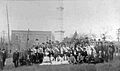
A historical image from Carrollton in 1905.

See also
 In Spanish: Carrollton (Misisipi) para niños
