Carson Mounds facts for kids
| Location | Stovall, Mississippi, |
|---|---|
| Region | Coahoma County, Mississippi |
| Coordinates | 34°17′37.4″N 90°40′16.04″W / 34.293722°N 90.6711222°W |
| History | |
| Cultures | Mississippian culture |
| Site notes | |
| Architecture | |
| Architectural styles | platform mounds, plazas |
| Architectural details | Number of temples: |
|
Carson Mounds
|
|
| Area | 186 acres (75 ha) |
| NRHP reference No. | 79003382 |
| Added to NRHP | April 19, 1979 |
| Responsible body: | |
The Carson Mounds (also called the Carson Site) is a very important archaeological site in Mississippi, USA. It is located near Clarksdale in Coahoma County, Mississippi. This large site was once home to people of the Mississippian culture. Today, only a few large earthen mounds remain. Experts believe Carson Mounds is one of the most significant ancient sites in Mississippi.
Contents
What is the History of Carson Mounds?
When Were the Mounds Built?
Scientists have used radiocarbon dating to learn about the site's age. People lived at Carson Mounds as early as 1040 CE. The large earthen mounds and villages were built after 1200 CE. The site was most active between 1420 and 1660 CE.
Early European Contact
Archaeologists think Carson Mounds was near or part of a native group. This group was met by Hernando de Soto's expedition in the 1540s. De Soto was one of the first European explorers in the southeastern United States. There is no direct proof that de Soto visited Carson Mounds. However, his group passed within 50 to 75 kilometers (30 to 45 miles) of the site. This happened when they traveled down the Mississippi River in July 1543.
Some experts believe the native group called Quizquiz was located near Carson Mounds. Other experts think Quizquiz was further north. The arrival of de Soto and his men caused big changes for native groups. Many native societies broke apart after this contact. No other Europeans visited the area until the late 1600s. By then, the large native chiefdoms de Soto saw had disappeared.
Modern Discoveries
Scientists first visited Carson Mounds in the late 1800s. These early explorers included people from the Smithsonian Institution. A map of the mounds was published in 1894. This map showed how large the settlement was. The mounds spread out over 1.6 kilometers (1 mile). Carson Mounds was a very big site for the Mississippian culture. It was also very important for local and regional politics.
The Carson Mounds site was added to the National Register of Historic Places in 1979. This means it is a special place that is protected.
Where are the Carson Mounds Located?
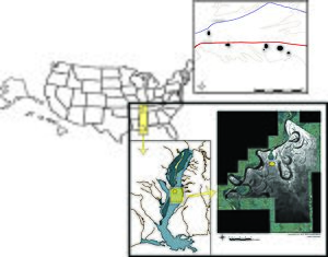
Carson Mounds is in the northern part of the Yazoo Basin. This is about 500 kilometers (300 miles) north of the Gulf of Mexico. It is also about 120 kilometers (75 miles) south of Memphis, Tennessee. The Yazoo Basin is a flat area formed by the Mississippi River. The mounds were built on a special type of land. This land was created by the Mississippi River about 2800 years ago.
What Did the Site Look Like?
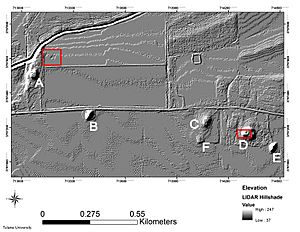
The Mississippian part of Carson Mounds was very large. It stretched about 2.4 kilometers (1.5 miles) east to west. It was about 0.8 kilometers (0.5 miles) north to south. The site covered about 60 hectares (150 acres). When it was first mapped in 1894, there were over eighty small earthen mounds. Only the Cahokia site in Illinois had more mounds.
Over time, most of these small mounds have been flattened by farming. Today, five large platform mounds remain. These mounds are arranged around open areas called plazas. The remaining mounds are between 3 meters (10 feet) and 12 meters (40 feet) tall. Next to Mound A, there was a large village. Archaeologists have found traces of over 30 homes there. This area was surrounded by an earthen wall and a ditch. A river protected its fourth side.
What Was Life Like at Carson Mounds?
Archaeologists have found many interesting things at Carson Mounds. They found evidence of flint-knapping. This is how people made stone tools. Some tools found here are similar to those from other big mound centers. These include sites like Cahokia and Bottle Creek Indian Mounds. This suggests that people at Carson Mounds traded or connected with these other places. Special pottery from Cahokia has also been found at Carson. You can see examples of this pottery at the Carnegie Public Library in Clarksdale, Mississippi.
Scientists have also studied human remains found at Carson. They discovered that people practiced artificial cranial deformation. This means they shaped the heads of infants. They flattened the forehead and the back of the head. This was likely done on purpose. It was a way to show that certain people had a special, important status in their society. This shaping happened when children were very young.
 | Misty Copeland |
 | Raven Wilkinson |
 | Debra Austin |
 | Aesha Ash |


