
Castleguard Cave facts for kids

Castleguard Cave is a famous cave found in the Rocky Mountains of Alberta, Canada. It's located at the northern end of Banff National Park. This amazing cave is Canada's longest, stretching over 20,357 meters (about 12.6 miles) of mapped passages. It's also one of the deepest, reaching down 384 meters (about 1,260 feet). The cave gently goes upwards from its entrance and ends right under the huge Columbia Icefield.
Contents
Exploring Castleguard Cave
Castleguard Cave might not be the biggest cave in the world, but it's very well-known among cavers and speleologists (people who study caves) around the globe. It's even been featured in a film and a book, and you'll find it mentioned in most cave guidebooks.
Why is Castleguard Cave so Special?
Part of what makes this cave so famous is its beautiful and remote mountain location. Since it's inside a protected national park, you can't drive right up to it. Also, the entrance can flood in the summer. Because of this, most explorations happen in the middle or late winter. Cavers often have to ski about 20 kilometers (12 miles) with sleds or arrive by helicopter.
The cave has a very long, straight layout with only one entrance. A classic trip from the entrance to the "Ice Plug" (its very end) covers about 9 kilometers (5.6 miles) of cave passage. Cavers often spend four or five days underground, resting at two special camps inside the cave.
Unique Cave Formations
Many caves in northern areas don't have many decorations, but Castleguard Cave is different! It has some beautiful sections with flowstone and stalactites. It's especially famous for its rare cubic cave pearls and many "flagged" soda straws. The deepest parts of Castleguard Cave are unique because they end in plugs of glacial ice. This ice is actually pushed into the cave from the huge icefield above!
Scientists have also found unique creatures living in the cave's pools. For example, a special type of amphipod (a small crustacean) called Stygobromus canadensis was discovered here in 1977. It's thought that these creatures might have used the cave as a safe place during past ice ages.
How Castleguard Cave Formed
Castleguard Cave is mostly found within a type of rock called Cathedral Formation limestone. The rocks here are tilted only slightly, which is why the cave passages are mostly flat. While the entrance and the very back sections are a bit more complicated, the middle part of the cave is mainly one long passage. This passage switches between narrow, rift-like sections and round, tube-like sections. Most of the cave is dry, but the entrance area can flood unexpectedly in the summer.
A Long History Underground
Castleguard Cave took a very long time to form. The part of the cave we can explore today, sometimes called Castleguard 1, was once an ancient underground river channel that is now dry. Studies of pollen found in the cave's dirt suggest that these passages were fully formed and dry at least one million years ago!
Scientists believe there's another cave system underneath, called Castleguard 2, which carries the water from the glacier today. This water then comes out at a place called Big Springs. There's also a third cave system, Castleguard 3, which collects meltwater from Castleguard Meadows. This system joins the main cave somewhere before Big Springs. We know Castleguard 3 exists because of special dye tracing tests, but cavers haven't been able to explore much of it yet.
Getting into the Cave
Since Castleguard Cave is inside Banff National Park, it's managed by Parks Canada. The entrance has had a gate on it since the 1970s, and access is restricted. However, local cavers work with Parks Canada to make sure that qualified groups can get permits to explore the cave.
Discovering and Mapping the Cave
People living in the area likely knew about the cave for a very long time. But the first recorded visit by someone outside the local community was in 1921. A man named Cecil Smith, who was guiding a trip, found the cave entrance. His client happened to be the head of the United States Geological Survey, and a few years later, the cave entrance was photographed for an article in National Geographic magazine.
Early Explorations
Over the years, local people probably visited the cave now and then. But the first official studies began in the summer of 1967. A group called the Karst Research Group from McMaster University in Hamilton, Ontario, led by Dr. Derek Ford, started exploring. They got past the first challenge, an 8-meter (26-foot) drop, and explored the main passage.
After two cavers, Peter Thompson and Mike Boon, got stuck in the cave because of sudden flooding near the entrance, future explorations were planned only for the winter. This made things much harder! The "Ice Plug," which is the very end of the cave, was found by Mike Boon during a solo trip in the winter of 1970. Soon after, cavers helped create a film called The Longest Cave. During the making of this film, some side passages were explored. Jane Mulkewich was the first woman to reach the Ice Plug.
Modern Discoveries
Exploration slowed down a bit after the national park put access rules in place. But it picked up again in the 1980s. During this time, Canadian and international teams explored most of the major side passages, like Boulevard du Quebec. These explorations brought the known length of Castleguard Cave to over 20 kilometers (12.4 miles). Explorations are still happening today, but it's getting harder to find new areas.
In 2005, a group from Norway spent three days climbing a vertical shaft called the "200-foot aven." It goes straight up from the cave floor about halfway in. They measured its height at 68 meters (223 feet) to the top chamber. While the chamber narrowed to a crack they couldn't get through, cavers always hope for more discoveries!
In 2009 and 2010, a team from the UK, supported by Canadians, explored a water-filled passage (called a sump) at Boon's Blunder. They dived 845 meters (2,772 feet) and found a significant dry passage beyond! Future explorations are expected in these new areas.
Mapping the Cave
While cavers were exploring, they were also busy surveying, or mapping, the cave. All the data was kept in different places, and people worried about how complete or accurate the maps were. So, a new mapping project was started, led by Steve Worthington. They also used cave radio to figure out where parts of the cave were from the surface.
Making a map that was seven meters (23 feet) long by hand was a huge task! The project was delayed until computer technology became available. After more work to check everything, add details, and survey new leads, a final digital map was created in late 2005. This map is updated whenever new parts of the cave are discovered and mapped.
Videos
Park Canada/NFB movie 1973 Derek Ford, Sid Perou, Haverand Productions, National Film Board of Canada and Parks Canada
Das Caver (English) (French)
Richard Patenaude (Amateur exploration expedition)
Images for kids
-
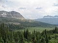
Looking down over Castleguard meadows.
-
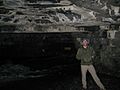
A gate blocks unauthorized entry just within the cave opening.
-
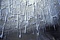
Flagged soda straws, Castleguard Cave.
-
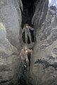
Second Fissure, Castleguard Cave.


