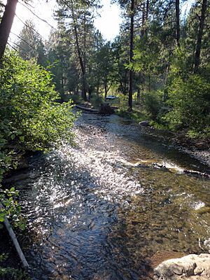
Catherine Creek facts for kids
Quick facts for kids Catherine Creek |
|
|---|---|

At Catherine Creek State Park
|
|
|
Location of the mouth of Catherine Creek in Oregon
|
|
| Country | United States |
| State | Oregon |
| County | Union |
| Physical characteristics | |
| Main source | Wallowa–Whitman National Forest 3,650 ft (1,110 m) 45°07′12″N 117°38′50″W / 45.12000°N 117.64722°W |
| River mouth | Grande Ronde River near Cove 2,690 ft (820 m) 45°18′49″N 117°52′20″W / 45.31361°N 117.87222°W |
| Length | 32.4 mi (52.1 km) |
| Basin features | |
| Basin size | 489 sq mi (1,270 km2) |
Catherine Creek is a stream in northeastern Oregon, United States. It is about 32 miles (52 km) long. This creek flows into the Grande Ronde River. It is the second-longest stream in the Grande Ronde Valley.
Catherine Creek starts in the foothills of the Wallowa Mountains. It then flows through Catherine Creek State Park and the city of Union. Finally, it joins the Grande Ronde River.
Contents
How Catherine Creek Got Its Name
Catherine Creek is named after a girl named Catherine Godley. She was the daughter of early settlers, Thomas and M. E. Godley. They moved to the area near Union in the 1800s.
Some old maps used to call this stream "Ladd Creek." However, the Ladd Creek on newer maps is a different stream. That Ladd Creek flows through the Ladd Marsh Game Management Area. It joins Gekeler Slough before entering Catherine Creek. Another stream, Little Creek, was once called Julianna Creek. This was for Julianna Godley, Catherine's sister.
Where Catherine Creek Flows
Catherine Creek flows only within Union County. It begins where the North Fork Catherine Creek and South Fork Catherine Creek meet. This meeting point is in the Wallowa–Whitman National Forest.
The creek flows generally northwest from the Wallowa Mountains. It runs along Oregon Route 203. Along its path, it receives water from smaller streams. These include Scout Creek and Milk Creek. It also gets water from Little Catherine Creek.
After this, the creek enters Catherine Creek State Park. It continues northwest through the city of Union. Here, Pyles Creek and Little Creek add to its flow. The creek then turns away from the highway. It winds north across the Grande Ronde Valley. It receives water from Ladd Creek and McAlister Slough. Mill Creek also joins it. Finally, Catherine Creek flows into the Grande Ronde River. This is west of Cove. The Grande Ronde River is a larger stream that flows into the Snake River.
Fun Things to Do at Catherine Creek
Catherine Creek is a great place for outdoor activities. You can go fishing and camping here.
Fishing for Trout and Salmon
You can fish for wild steelhead in Catherine Creek. This is allowed downstream of the Highway 203 bridge. It is a "catch-and-release" area. This means you must put the fish back in the water.
Chinook salmon also live in the creek and its forks. They are found where the creek flows through the national forest. This is about 5 miles (8 km) upstream of the state park. However, you cannot fish for Chinook salmon or bull trout in these areas. They are protected. Small wild rainbow trout also live in the upper parts of the creek.
Camping and Picnics
Catherine Creek State Park is about 8 miles (13 km) from Union. It has a public campground where you can stay. You can also camp at a site in the national forest.
The campground at the 168-acre (68 ha) state park is open for many months. It is open from mid-April through October. The park also has nice picnic areas. There are restrooms and horseshoe pits for games. You can also enjoy hiking on the park's trails.
 | Emma Amos |
 | Edward Mitchell Bannister |
 | Larry D. Alexander |
 | Ernie Barnes |


