Grande Ronde Valley facts for kids
Quick facts for kids Grande Ronde Valley |
|
|---|---|
| Floor elevation | 820 m (2,690 ft) |
| Length | 35 miles North to South |
| Width | 15 miles |
| Geology | |
| Type | Flood basalt |
| Geography | |
| Location | Union County, Oregon, United States |
| Borders on | Blue Mountains |
| Rivers | Grand Ronde River |
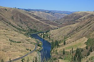
The Grande Ronde Valley is a beautiful valley located in Union County, in the northeastern part of Oregon, United States. It's surrounded by the tall Blue Mountains and has the Grande Ronde River flowing through it. La Grande is the biggest town in the valley.
The valley is about 35 miles (56 km) long from north to south and 15 miles (24 km) wide from east to west. Its name, "Grande Ronde," means "great circle" in French, which perfectly describes its round shape.
Contents
How the Grande Ronde Valley Was Formed
The Grande Ronde Valley is part of the huge Columbia River Plateau. This plateau was made a long, long time ago by many basalt flood eruptions. Imagine giant cracks opening in the Earth's crust, letting out huge amounts of hot, melted rock called lava. This lava then spread out and hardened, forming thick layers of rock called basalt.
About nine million years ago, the floor of the Grande Ronde Valley slowly started to sink from this high plateau. It sank very gradually, only about 0.07 to 0.18 millimeters each year.
Exploring the Grande Ronde Valley's Landscape
The floor of the Grande Ronde Valley sits about 2,700 feet (820 meters) above sea level. When you look around, you'll see the impressive Blue Mountains all around you. To the southeast, you'll find the wild Eagle Cap Wilderness.
Some of the highest mountains nearby include Mount Fanny to the east, which is 7,136 feet (2,175 meters) tall. To the northeast is Mount Harris, at 5,335 feet (1,626 meters), and to the northwest is Mount Emily, standing at 6,110 feet (1,862 meters).
Many towns are located inside the valley, such as Cove, Imbler, Island City, La Grande, Summerville, and Union. The Grande Ronde River flows through the valley, and smaller streams like Catherine, Fir, Ladd, Little, Mill, Pyles, and Willow creeks flow into it.
A Look at the Valley's Past
Early People of the Valley
Long ago, the area of Eastern Oregon and its surroundings was a special place for many Native American tribes. Tribes like the Nez Perce, Cayuse, Umatilla, Walla Walla, and Shoshone would spend their summers in the rich Grande Ronde Valley.
Here, they would gather food, hunt, fish, and relax in the warm hot springs. Even tribes that sometimes didn't get along would live together peacefully in what they called the "Valley of Peace."
First Explorers and Settlers Arrive
In 1811, the Astor Expedition traveled through the valley. Later, it became an important stop along the famous Oregon Trail. Starting in the 1840s, pioneers heading to the Willamette Valley would pass through this area. Everyone who wrote about their journey through the valley had good things to say about it.
However, early pioneers didn't settle there right away. Maybe they were focused on reaching the Willamette Valley, or it was too far from places to get supplies, or they were worried about the Native Americans living there. The first permanent settlement in the Grande Ronde Valley wasn't built until 1861.
The first person to settle permanently was Benjamin Brown, an Englishman. Soon after, the Leasey family and about 20 other people joined him. This settlement started as a place for travelers to stay and was first called Brown's Fort, then Browns Town or Brownsville. But since there was already a Brownsville in Linn County, the name was changed to La Grande.
How the Valley Grew
The first settlements were in the northern parts of the valley, where the land was better for farming. The southern end often flooded, was swampy, and had salty soil. In 1862, Conrad Miller settled on the other side of the valley. This settlement grew into the city of Union, which became the second-largest community in the Grande Ronde Valley. Other towns like Island City, Cove, and Summerville soon followed.
Many things helped the valley grow. More and more people kept coming through on the Oregon Trail. Also, gold was discovered in the areas nearby, like at Baker in 1861 and the Powder River Mines in 1862. This brought many people hoping to find riches.
The Railroad Comes to Town
Building railroads was a big goal for many people. In 1872, some tried to build a railroad called the Grande Ronde and Walla Walla Railroad, but it was never finished. Another effort was made to connect to a railroad from Walla Walla to the Columbia River.
In 1878, people in La Grande started a plan to build a railroad from La Grande to the Columbia River at Umatilla. They formed a company and started preparing the land. In 1879, a bigger company, the Oregon Railway and Navigation Company, took over the project.
These new railroad lines would connect to the Oregon Short Line and Union Pacific railroads at Huntington. This meant the valley would no longer rely on difficult wagon roads. As one pioneer woman wrote, "No more big, heavily loaded freight wagons with their wheels buried to the hub in mud."
There was a friendly competition between La Grande and Union. Both towns wanted the railroad to pass through them. Engineers came to survey the routes, and both towns tried their best to impress them. In the end, the route through La Grande was chosen. The railroad was finished in 1884, bringing a new era of transportation to the valley.
The Oregon Railway and Navigation Company also built a smaller train line from La Grande to Elgin.
Getting Around the Grande Ronde Valley
There are six main ways to travel in and out of the Grande Ronde Valley:
- Old Oregon Trail Highway (North) (Interstate 84): This highway leaves the valley on the west side, going through the Grande Ronde River canyon. It travels through the Blue Mountains towards Pendleton.
- Old Oregon Trail Highway (South) (Interstate 84): Going south, this highway exits the valley through Ladd Canyon. It then goes into Powder Valley and continues towards Baker City.
- Wallowa Lake Highway (Oregon Route 82): This highway leaves the valley on the other side of the Grande Ronde River canyon in the north. It enters Indian Valley and continues until it reaches Wallowa Lake.
- La Grande-Baker Highway (Oregon Route 237): This highway exits the valley through Pyles Canyon. After passing North Powder and Interstate 84, it becomes U.S. Route 30 and continues to Baker City.
- Medical Springs Highway (Oregon Route 203): This highway leaves the valley through the canyon of Catherine Creek. It travels to Medical Springs and then ends on Interstate 84 near Baker City.
- Tollgate Road (Oregon Route 204): This highway starts at Elgin and goes north through Tollgate. It then travels west and ends at Weston.
 | Valerie Thomas |
 | Frederick McKinley Jones |
 | George Edward Alcorn Jr. |
 | Thomas Mensah |


