Union, Oregon facts for kids
Quick facts for kids
Union, Oregon
|
|
|---|---|

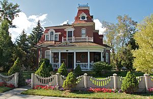
The Eaton House, a Victorian home in the Union Main Street Historic District
|
|
| Motto(s):
"City of Victorian Heritage"
|
|

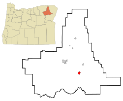
Location in Oregon
|
|
| Country | United States |
| State | Oregon |
| County | Union |
| Incorporated | 1878 |
| Area | |
| • Total | 2.49 sq mi (6.45 km2) |
| • Land | 2.49 sq mi (6.45 km2) |
| • Water | 0.00 sq mi (0.00 km2) |
| Elevation | 2,786 ft (849 m) |
| Population
(2020)
|
|
| • Total | 2,152 |
| • Density | 864.60/sq mi (333.84/km2) |
| Time zone | UTC-8 (Pacific) |
| • Summer (DST) | UTC-7 (Pacific) |
| ZIP code |
97883
|
| Area code(s) | 541 |
| FIPS code | 41-75850 |
| GNIS feature ID | 2412129 |
| Website | www.cityofunion.com |
Union is a small city in Union County, Oregon, United States. It was first planned out in 1864. The city is about 15 miles (24 km) southeast of La Grande.
Union is named after the Union states (Northern States) from the American Civil War. In 2020, about 2,152 people lived there. The city is famous for its many old Victorian homes. Some of these homes are even listed on the National Register of Historic Places. Union is also home to a research center for Oregon State University. This center, founded in 1888, is now located in the old train station.
Contents
History of Union
Union was officially planned on November 11, 1864. It was located along the famous Oregon Trail. The city's name comes from the "Union states" of the American Civil War. These were the Northern states that stayed together during the war.
When Union County was created in 1865, La Grande was chosen as the county seat. This meant La Grande was the main town for government. In 1872, Union became the county seat because a major road, the Thomas and Ruckle Road, passed through it.
However, things changed when the railroad was built. The railroad went through La Grande instead of Union. This helped La Grande grow much bigger. So, in 1902, La Grande became the county seat again.
Local attorney J. W. Shelton wanted to bring the railroad to Union. In 1890, he started a company to build a rail line. By 1892, a short rail line was built into Union. Shelton had plans for more lines, but he had disagreements with his business partners.
Two different companies then competed to control the railroad in Union. Shelton kept control of his company until 1905. His company was later bought by a timber company.
Young Mayor of Union
In the 2006 November elections, something interesting happened. Kyle Corbin, an 18-year-old college student, was elected mayor of Union. He won as a write-in candidate, meaning people wrote his name on the ballot.
Kyle promised to fix political problems in the town. Before him, three council members and the previous mayor had been removed from office. He told a reporter, "I know the procedures and rules." He added, "I've run a meeting with a bunch of high school kids." People in Union had mixed feelings about whether the young mayor would succeed.
Geography of Union

Union is located in the very southeast part of the Grande Ronde Valley. It is also close to the western edge of the Wallowa Mountains.
Oregon Route 237 goes through Union. This road connects Union to Cove in the north and North Powder in the south. Another road, Oregon Route 203, also passes through Union. It links Union to La Grande, which is about 20 miles (32 km) northwest.
Catherine Creek, a stream that flows into the Grande Ronde River, runs through the city. The United States Census Bureau says that Union covers about 2.50 square miles (6.47 square kilometers) of land. There is no water area within the city limits.
Climate in Union
| Climate data for Union Experiment Station, Oregon (1981–2010 normals, extremes 1911–2011) | |||||||||||||
|---|---|---|---|---|---|---|---|---|---|---|---|---|---|
| Month | Jan | Feb | Mar | Apr | May | Jun | Jul | Aug | Sep | Oct | Nov | Dec | Year |
| Record high °F (°C) | 61 (16) |
67 (19) |
77 (25) |
90 (32) |
95 (35) |
101 (38) |
105 (41) |
108 (42) |
101 (38) |
89 (32) |
74 (23) |
62 (17) |
108 (42) |
| Mean daily maximum °F (°C) | 38.5 (3.6) |
43.5 (6.4) |
52.3 (11.3) |
59.0 (15.0) |
66.8 (19.3) |
74.4 (23.6) |
84.9 (29.4) |
85.7 (29.8) |
76.3 (24.6) |
62.7 (17.1) |
47.3 (8.5) |
38.1 (3.4) |
60.8 (16.0) |
| Daily mean °F (°C) | 32.0 (0.0) |
35.2 (1.8) |
41.6 (5.3) |
46.8 (8.2) |
53.7 (12.1) |
60.4 (15.8) |
67.7 (19.8) |
67.5 (19.7) |
58.9 (14.9) |
48.4 (9.1) |
38.9 (3.8) |
31.3 (−0.4) |
48.5 (9.2) |
| Mean daily minimum °F (°C) | 25.4 (−3.7) |
26.8 (−2.9) |
30.9 (−0.6) |
34.6 (1.4) |
40.7 (4.8) |
46.4 (8.0) |
50.5 (10.3) |
49.3 (9.6) |
41.6 (5.3) |
34.1 (1.2) |
30.6 (−0.8) |
24.5 (−4.2) |
36.3 (2.4) |
| Record low °F (°C) | −27 (−33) |
−21 (−29) |
−3 (−19) |
9 (−13) |
20 (−7) |
29 (−2) |
32 (0) |
28 (−2) |
18 (−8) |
7 (−14) |
−12 (−24) |
−24 (−31) |
−27 (−33) |
| Average precipitation inches (mm) | 1.17 (30) |
0.91 (23) |
1.23 (31) |
1.51 (38) |
2.16 (55) |
1.58 (40) |
0.67 (17) |
0.70 (18) |
0.67 (17) |
1.08 (27) |
1.56 (40) |
1.16 (29) |
14.40 (366) |
| Average snowfall inches (cm) | 6.0 (15) |
3.0 (7.6) |
1.3 (3.3) |
0.5 (1.3) |
0.1 (0.25) |
0.0 (0.0) |
0.0 (0.0) |
0.0 (0.0) |
0.0 (0.0) |
trace | 2.1 (5.3) |
4.8 (12) |
17.8 (45) |
| Average precipitation days (≥ 0.01 in) | 11.8 | 9.2 | 11.9 | 11.9 | 12.2 | 9.2 | 4.4 | 4.4 | 5.1 | 8.5 | 13.4 | 11.7 | 113.7 |
| Average snowy days (≥ 0.1 in) | 5.7 | 3.1 | 1.9 | 0.6 | 0.1 | 0.0 | 0.0 | 0.0 | 0.0 | 0.1 | 2.1 | 5.0 | 18.6 |
| Source: NOAA | |||||||||||||
People of Union
| Historical population | |||
|---|---|---|---|
| Census | Pop. | %± | |
| 1880 | 416 | — | |
| 1890 | 604 | 45.2% | |
| 1900 | 937 | 55.1% | |
| 1910 | 1,483 | 58.3% | |
| 1920 | 1,319 | −11.1% | |
| 1930 | 1,107 | −16.1% | |
| 1940 | 1,398 | 26.3% | |
| 1950 | 1,307 | −6.5% | |
| 1960 | 1,490 | 14.0% | |
| 1970 | 1,531 | 2.8% | |
| 1980 | 2,062 | 34.7% | |
| 1990 | 1,847 | −10.4% | |
| 2000 | 1,926 | 4.3% | |
| 2010 | 2,121 | 10.1% | |
| 2020 | 2,152 | 1.5% | |
| U.S. Decennial Census | |||
Union's Population in 2010
In 2010, the city of Union had 2,121 people living there. There were 859 households and 603 families. A household means all the people living in one home.
The city had about 848 people per square mile (327 people per square kilometer). Most of the people (95.6%) were White. Small numbers of other groups also lived there, including Native American, Asian, and Pacific Islander people. About 2.3% of the population was Hispanic or Latino.
About 31.4% of homes had children under 18 living with them. Most homes (56.7%) were married couples. Some homes had a single parent or a person living alone. The average household had 2.46 people.
The average age of people in Union was 43.8 years old. About 24.7% of residents were under 18. About 17.9% were 65 years or older. The population was almost evenly split between males (49.2%) and females (50.8%).
See also
 In Spanish: Union (Oregón) para niños
 | James Van Der Zee |
 | Alma Thomas |
 | Ellis Wilson |
 | Margaret Taylor-Burroughs |


