Celaya facts for kids
Quick facts for kids
Celaya
|
||
|---|---|---|
|
City and municipality
|
||
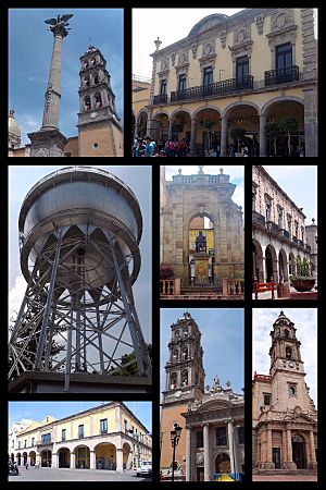
Ángel de la Independencia, Andador Guadalupe, Bola de agua, Estatua a Tresguerras, Portal Colunga, Catedral de San Francisco, Iglesia de la Virgen del Carmen y Palacio Municipal.
|
||
|
||
| Nickname(s):
The Golden Gate of the Bajío
|
||
| Motto(s):
"De Forti Dulcedo" (La Dulzura del Fuerte)
|
||
| Country | ||
| State | Guanajuato | |
| Municipality | Celaya | |
| Foundation | October 12, 1570 | |
| Founded as | Villa de la Purisíma Concepción de Zalaya | |
| Founded by | Martín Enríquez de Almanza | |
| Area | ||
| • City | 65.3 km2 (25.2 sq mi) | |
| • Municipality | 553.1 km2 (213.6 sq mi) | |
| Elevation | 1,767 m (5,797 ft) | |
| Population
(2020 census)
|
||
| • City | 340,387 | |
| • Density | 5,213/km2 (13,501/sq mi) | |
| • Metro | 717,616 | |
| • Municipality | 521,169 | |
| • Municipality density | 942.27/km2 (2,440.47/sq mi) | |
| GDP (PPP, constant 2015 values) | ||
| • Year | 2023 | |
| • Total (Metro area) | $15 billion | |
| • Per capita | $21,200 | |
| Time zone | UTC-6 (Central Standard Time) | |
| • Summer (DST) | UTC-5 (Central Daylight Time) | |
| Postal code |
38000 - 38159
|
|
| Area code(s) | 461 | |
| Airport | Aeropuerto Nacional Capitán Rogelio Castillo | |
| Website | http://www.celaya.gob.mx | |
Celaya (Spanish pronunciation: [seˈlaja]) is a vibrant city in the state of Guanajuato, Mexico. It is located in the southeastern part of the state. Celaya is the third most populated city in Guanajuato. In 2005, about 310,413 people lived there. The larger area, called the municipality, had a population of 415,869.
The city is known as "The Golden Gate of the Bajío". Its name, "Zalaya," comes from the Basque language. It means "Flat Land." Celaya was founded on October 12, 1570. It was first called Villa de la Purisíma Concepción de Zalaya.
Contents
Exploring Celaya's Past
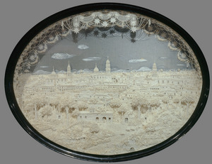
Celaya was once a border area. It was located between the lands of the Purépecha people and the Chichimecas.
A famous battle took place here in 1915. General Álvaro Obregón defeated Pancho Villa in the Battle of Celaya. For a short time, Celaya was even the capital city of Guanajuato state.
In September 1999, an explosion happened at a fireworks warehouse. This sad event caused many injuries and fatalities.
Celaya's Climate and Location
Weather in Celaya
Celaya has a semi-arid climate. This means it's generally dry with hot summers and mild winters. It doesn't get a lot of rain.
| Climate data for Celaya | |||||||||||||
|---|---|---|---|---|---|---|---|---|---|---|---|---|---|
| Month | Jan | Feb | Mar | Apr | May | Jun | Jul | Aug | Sep | Oct | Nov | Dec | Year |
| Record high °C (°F) | 36.0 (96.8) |
33.0 (91.4) |
39.0 (102.2) |
39.0 (102.2) |
38.5 (101.3) |
38.0 (100.4) |
33.5 (92.3) |
33.0 (91.4) |
33.0 (91.4) |
34.0 (93.2) |
35.0 (95.0) |
34.0 (93.2) |
39.0 (102.2) |
| Mean daily maximum °C (°F) | 24.7 (76.5) |
26.1 (79.0) |
28.5 (83.3) |
30.2 (86.4) |
31.3 (88.3) |
29.4 (84.9) |
27.3 (81.1) |
27.4 (81.3) |
27.1 (80.8) |
26.7 (80.1) |
26.5 (79.7) |
25.3 (77.5) |
27.5 (81.5) |
| Daily mean °C (°F) | 15.1 (59.2) |
16.2 (61.2) |
18.5 (65.3) |
20.6 (69.1) |
22.4 (72.3) |
22.1 (71.8) |
20.8 (69.4) |
20.7 (69.3) |
20.4 (68.7) |
19.0 (66.2) |
17.6 (63.7) |
16.2 (61.2) |
19.1 (66.4) |
| Mean daily minimum °C (°F) | 5.5 (41.9) |
6.4 (43.5) |
8.4 (47.1) |
11.0 (51.8) |
13.6 (56.5) |
14.9 (58.8) |
14.3 (57.7) |
14.0 (57.2) |
13.6 (56.5) |
11.4 (52.5) |
8.7 (47.7) |
7.0 (44.6) |
10.7 (51.3) |
| Record low °C (°F) | −3.5 (25.7) |
−3.5 (25.7) |
−3.0 (26.6) |
1.0 (33.8) |
6.0 (42.8) |
7.0 (44.6) |
8.5 (47.3) |
6.5 (43.7) |
3.0 (37.4) |
3.5 (38.3) |
−1.5 (29.3) |
−3.5 (25.7) |
−3.5 (25.7) |
| Average precipitation mm (inches) | 12.5 (0.49) |
5.7 (0.22) |
8.5 (0.33) |
14.6 (0.57) |
31.0 (1.22) |
97.5 (3.84) |
140.6 (5.54) |
120.7 (4.75) |
94.3 (3.71) |
36.3 (1.43) |
14.5 (0.57) |
8.8 (0.35) |
585.0 (23.03) |
| Average precipitation days (≥ 0.1 mm) | 2.2 | 1.2 | 1.5 | 2.5 | 5.3 | 10.7 | 13.8 | 12.8 | 9.8 | 4.9 | 2.2 | 1.8 | 68.7 |
| Source: Servicio Meteorologico Nacional | |||||||||||||
Learning in Celaya
Celaya has many schools and universities. Here are some of them:
- Centro Pedagogico de Celaya
- Colegio Arturo Rosenblueth
- Colegio Marista
- Colegio Nuevo Continente Bajío Celaya Campus
- Complejo Educativo Ignacio Allende
- Colegio Mexico
- Escuela Bilingue Guilford
- Instituto Andersen
- Instituto Bilingue Oxford
- Instituto Británico de Celaya (BIC)
- Instituto Educativo Rosa G. de Carmona
- Instituto Sir Winston Churchill
- Instituto Tecnologico de Celaya
- Instituto Tecnologico de Roque
- Instituto Universitario del Centro de México (UCEM)
- Universidad de Celaya
- Universidad de Guanajuato
- Universidad de Itesba
- Universidad Lasallista Benavente
- Universidad Latina de Mexico
- Westminster Royal College
Fun Places to Visit in Celaya
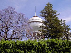
The Ball of Water
The "Ball of Water" is a famous landmark in Celaya. It's a large water tower that has been around since 1908. It still helps supply water to parts of the city center. This unique tank was made in Germany and put together on site. It's special because it was built using rivets, not welds.
People in Celaya sometimes joke that the water tower is filled with cajeta. Cajeta is a delicious milk candy that Celaya is also famous for making.
A plaque at the base of the tower tells its story:
'"This tower was built at the expense of the city municipality in 1910 and officially opened on 15 September, the day of the anniversary of the proclamation of the independence of Mexico as a state governor Mr. Don Joaquín González Obregón, who gave full moral support to the construction.'s work and everything related to the provision of drinking water, was designed and conducted by the district political head Mr. Don Perfecto I. Aranda, its total cost, including piping limited to two circuits, was $ 161,520.84 (mexican old) pesos ".
During the Mexican Revolution, some soldiers thought destroying the tower would flood the city. But a captain named Gustavo Duron protected it by shooting around it. This saved the monument. For many years, ads were placed on the tower to help pay for its upkeep. But in 1980, it was decided that the Ball of Water would be a symbol of Celaya. Since then, no more ads are allowed on it.
Getting Around Celaya
Celaya is located along Mexican Federal Highway 45. This highway is part of the larger Pan-American Highway system. The city also has an airport, the Aeropuerto Nacional Capitán Rogelio Castillo.
Famous People from Celaya
Many notable people have connections to Celaya:
- Marta Sahagún de Fox (born 1953): She was the First Lady of Mexico and wife of President Vicente Fox.
- Guillermo Martínez (born 1995): A professional footballer.
- Miguel Martínez (born 1921): A musician, composer, and songwriter. He is known as the father of the modern mariachi trumpet.
- Francisco Eduardo Tresguerras (1759–1833): A famous architect and painter. He designed the beautiful El Carmen church in Celaya.
- Joshua Ilika Brenner (born 1976): An Olympic swimmer.
- Liliana Ibáñez (born 1991): Another Olympic swimmer.
- Raúl Velasco (1933–2006): A well-known entertainer and TV producer. He hosted the popular TV show Siempre en Domingo.
- Octavio Ocampo (born 1943): A painter famous for his "metamorphosis" style of art.
- Mauricio Ochmann (born 1977): An actor.
- Ever Guzmán (born 1988): A professional footballer.
- José Juan Vázquez (born 1988): A professional footballer.
- David Roberto Bárcena Ríos (1941–2017): A Mexican equestrian who competed in five Olympic Games and won a bronze medal.
Celaya's Sister Cities
Celaya has special connections with other cities around the world. These are called sister cities:
 Carrboro, North Carolina, United States
 Chapel Hill, North Carolina, United States
 Guernica, Spain
 Oaxaca, Mexico
 Tuxtla Gutiérrez, Mexico
See also
 In Spanish: Celaya para niños
 | Mary Eliza Mahoney |
 | Susie King Taylor |
 | Ida Gray |
 | Eliza Ann Grier |


