Cerro Romauldo facts for kids
Quick facts for kids Cerro Romauldo |
|
|---|---|

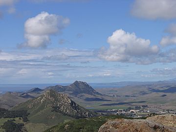
Cerro Romauldo is at the bottom left. The National Guard base is to its right. This picture looks northwest from the top of Bishop Peak.
|
|
| Highest point | |
| Elevation | 1,300 ft (396 m) NAVD 88 |
| Naming | |
| English translation | Romauldo Hill |
| Language of name | Spanish |
| Geography | |
| Parent range | Santa Lucia Range |
| Topo map | San Luis Obispo |
| Geology | |
| Age of rock | 20 million years |
| Mountain type | Volcanic plug |
| Volcanic field | Nine Sisters |
| Climbing | |
| Easiest route | Not open to the public |
Cerro Romauldo is a hill in San Luis Obispo County, California. It stands about 1,300 feet (396 meters) tall. This hill is one of a special group of nine hills called the Nine Sisters. These hills are actually ancient volcanic plugs. Until 1964, its official name was Romauldo Peak.
Contents
What is Cerro Romauldo?
Cerro Romauldo is a tall hill in California. It is part of a line of nine hills. These hills are called the Nine Sisters. They are all old volcanoes. A volcanic plug is like a giant stopper. It forms when magma cools and hardens inside a volcano's vent. Over millions of years, the softer rock around it wears away. This leaves behind the hard, plug-shaped rock. Cerro Romauldo is the fifth hill in this chain. It is about 20 million years old.
How did it get its name?
The name Cerro Romauldo comes from a Chumash man. The Chumash are a Native American group. This man received a large piece of land. It was a Mexican land grant in 1842. The land was called Rancho Huerta de Romauldo. Huerta de Romauldo means Romauldo's kitchen garden or orchard in Spanish. The land was given to him by Pío Pico. He was the last Mexican Governor of Alta California. In 1846, Romauldo sold his land. He sold it to a man named Captain John Wilson.
What is it used for today?
Today, the State of California owns Cerro Romauldo. It is used by the California National Guard. The National Guard is a part of the U.S. military. They use the hill for fitness training. Their base, Camp San Luis Obispo, is right next to it. This means the hill is not open to the public.
A bit of history
In the 1890s, people used rocks from Cerro Romauldo. They used them to build the Southern Pacific Railroad. This railroad helped connect different parts of California.


