Chaitén (volcano) facts for kids
Quick facts for kids Chaitén |
|
|---|---|
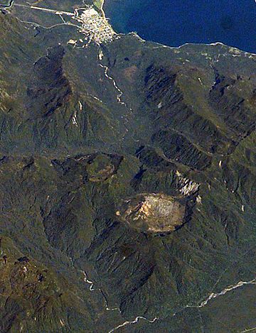
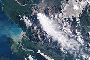
2003 photograph from the International Space Station.
The caldera is the circular feature visible in the lower part of the image. The town of Chaitén is to the top. (This image is aligned roughly southwest, around 220°.) |
|
| Highest point | |
| Elevation | 1,122 m (3,681 ft) |
| Geography | |
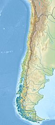
| Location | 10 kilometres (6 mi) northeast of Chaitén, Palena Province, Los Lagos Region, Chile |
| Parent range | Andes |
| Geology | |
| Mountain type | Caldera |
| Volcanic belt | South Volcanic Zone |
| Last eruption | 2008 to 2011 |
Chaitén is a volcano in southern Chile. It is a type of volcano called a caldera, which is like a large bowl-shaped hollow formed after a volcano erupts and collapses. Chaitén's caldera is about 3 kilometres (2 mi) wide. It is located near the town of Chaitén and the Gulf of Corcovado.
The volcano's most recent eruption started in 2008 and lasted until 2011. Before this, scientists thought its last eruption was around 7420 BC. However, new studies show that Chaitén has been more active than previously believed.
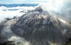
The edge of the caldera reaches 1,122 metres (3,681 ft) above sea level. Before the 2008 eruption, the caldera was mostly filled by a dome of rhyolite obsidian lava. This dome was 962 metres (3,156 ft) tall and didn't have much plant life on it. There were also two small lakes inside the caldera.
The clear, grey obsidian rock from Chaitén was very important. People from ancient cultures in the area used it to make tools and other items. This obsidian has been found far away, up to 400 kilometres (250 mi) to the south and north of the volcano.
Contents
The 2008 Eruption: A New Beginning

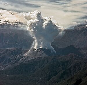
Chaitén volcano began a new eruption on May 3, 2008. This was its first major eruption in hundreds of years. The Chilean government quickly started to evacuate the nearby town of Chaitén, which had about 4,200 people. Most residents were moved to safety by May 3. Sadly, one elderly person died during the evacuation while traveling by sea.
By the afternoon of May 3, a huge cloud of ash from the volcano had spread far across Chile and into Argentina. It even reached the Atlantic Ocean. This ash contaminated water supplies. The town of Futaleufú, about 75 kilometres (47 mi) southeast, was covered in ash. Later studies showed the ash was about 5–10 centimetres (2.0–3.9 in) thick there.
Eruption's Power and Evacuations
Scientists from the US came to the area to check the air quality and the dangers from chemicals in the ash. The first part of the 2008 eruption involved a lot of ash coming out and ground shaking. In 2005, smaller earthquakes had been felt near the volcano.
On May 6, 2008, the eruption became much stronger. It produced dangerous pyroclastic flows, which are fast-moving currents of hot gas and volcanic debris. The ash cloud rose very high, possibly up to 30,000 metres (98,000 ft). Because of this, almost everyone remaining in Chaitén and nearby villages, including Futaleufú, had to be evacuated.
Changes in the Crater
In the early days of the eruption, two separate openings formed in the old lava dome. By May 6, these had joined into one large opening about 800 metres (2,600 ft) wide. Experts warned that more large pyroclastic events were possible and that the eruption could continue for a long time.
Throughout May and June 2008, the eruption continued with ash emissions and pyroclastic flows, but it slowly became less intense. On May 21, a new lava dome started to grow inside the crater. By May 24, this new dome was taller than the old one. It kept growing, eventually blocking the water drainage from the caldera floor.
By July 3, 2008, Chaitén was still erupting. There was still ground shaking, an ash column up to 3,000 metres (9,800 ft) high, and the lava dome was still growing. Scientists were unsure if the new dome would be stable, meaning there was a risk it could collapse and cause another explosive eruption.
In August 2008, an expedition reached the volcano's summit. They found the lava dome was 120 metres (390 ft) high. Earthquakes were felt, and the dome was making loud noises as gas escaped. Hot rocks were also falling from the dome.
On February 19, 2009, part of the lava dome collapsed. This caused pyroclastic flows to rush down the Chaitén river valley, reaching about 5 kilometres (3 mi) from the town. Ash again fell on Futaleufú and parts of Chubut province in Argentina. The remaining 160 people in Chaitén were strongly urged to leave, and most were evacuated that day.
Impact and Recovery of the Area
Forests near the volcano were burned by the hot pyroclastic flows and explosions. Large areas of southern Argentina and Chile were covered in ash. This ash can affect farming, though it can also add new minerals to the soil over time. A lot of ash fell in some places, creating a risk of lahars. Lahars are dangerous mudflows made of volcanic ash and water.
Chaitén Town's Struggle and Comeback
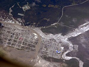
Starting on May 12, 2008, lahars caused severe flooding in the town of Chaitén. Ash mud covered many buildings, sometimes over a meter deep. The original path of the Chaitén River through the town was completely filled. Over the next few weeks, the river carved a new path, destroying a large part of the town by July 2008.
The government tried to protect the town and even planned to move it about 10 kilometres (6 mi) north. While those plans haven't been fully completed, the town of Chaitén is slowly recovering. Today, its population is about 900 people.
Why Chaitén's Eruption Was Special
The 2008 eruption of Chaitén was very rare. It was the first major explosive eruption of rhyolite magma in almost a century. The last one of this size was the 1912 eruption of Novarupta in Alaska. While there have been other rhyolitic eruptions in southern Chile, none have been as big as Chaitén's in recorded history.
See also
 In Spanish: Volcán Chaitén para niños


