Futaleufú, Chile facts for kids
Quick facts for kids
Futaleufú
|
||||||
|---|---|---|---|---|---|---|
|
Town and Commune
|
||||||
|
||||||
| Nickname(s):
"Futa"
|
||||||
| Country | Chile | |||||
| Region | Los Lagos | |||||
| Province | Palena | |||||
| Government | ||||||
| • Type | Municipality | |||||
| Area | ||||||
| • Total | 1,280.0 km2 (494.2 sq mi) | |||||
| Elevation | 353 m (1,158 ft) | |||||
| Population
(2012 Census)
|
||||||
| • Total | 2,297 | |||||
| • Density | 1.7945/km2 (4.6478/sq mi) | |||||
| • Urban | 1,153 | |||||
| • Rural | 673 | |||||
| Sex | ||||||
| • Men | 954 | |||||
| • Women | 872 | |||||
| Area code(s) | 56 + 65 | |||||
| Climate | Cfb | |||||
| Website | Municipality of Futaleufú | |||||
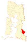
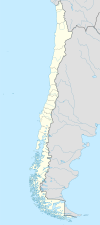
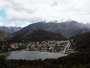
Futaleufú is a cool town in Chile, located in a beautiful area called Northern Patagonia. It's nestled where the Espolon and Futaleufú rivers meet, only about 10 kilometers (6 miles) from the border with Argentina. Futaleufú is also the main town of Palena Province in the Los Lagos Region.
Locally, people call it "Futa." It's a growing spot for tourists who love adventure. The most popular activity is whitewater rafting. You can also enjoy fishing, mountain biking, hiking, and canyoning.
Because it's so close to Argentina, many visitors fly into airports in Esquel or Bariloche, Argentina. Other ways to get there include flying to Chaitén in Northern Patagonia or taking ferries from Puerto Montt, a major Chilean city.
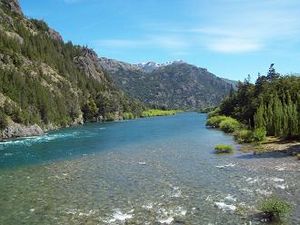
The town gets its name from the amazing, clear blue Futaleufú River. Many people think it's one of the best rivers in the world for whitewater rafting. The name "Futaleufú" comes from the Mapudungun language and means "Big River."
About 2,000 people live in Futaleufú. This number grows a bit during the summer when more tourists arrive for rafting and kayaking. The town's main income comes from outdoor sports like whitewater rafting, kayaking, and fly fishing. Some original residents also raise sheep and cattle or do small-scale farming. A gravel road connects the town to Trevelin in Argentina and to the Carretera Austral, a famous Chilean highway. The town also has its own small airport, Futaleufú Airfield.
After the Chaitén Volcano erupted and damaged the town of Chaitén, Futaleufú became the administrative capital of Palena Province in March 2009.
Contents
Climate in Futaleufú
Futaleufú has an oceanic climate, which means it has cool, wet winters and drier, mild summers. This type of climate is known as Cfb in the Köppen climate classification system.
Winter Weather
Winters are cool and rainy, but not extremely cold. The average temperature in July is about 3.6°C (38.5°F). There's a lot of rain from June to August, usually between 253 to 301 mm (10 to 12 inches) each month. It's also very humid, with humidity levels around 77–86%. Most winter days have some rain, with 18–19 rainy days per month. Snow falls most years, but heavy, long-lasting snow is rare.
Summer Weather
Summers are milder and less rainy. The average temperature in January is about 16.8°C (62.2°F). February is the driest month, with about 81.1 mm (3.2 inches) of rain. However, the amount of rain in summer can change a lot from year to year. Sometimes, there's very little rain, like in January 1987 when only 9.9 mm (0.4 inches) fell. Other times, it can rain a lot, like in January 1974 when over 300 mm (12 inches) fell. Temperatures can sometimes go above 20°C (68°F) between September and May.
Rainfall and Temperature Records
On average, Futaleufú gets about 2081.2 mm (81.9 inches) of rain each year. There are about 169 days with measurable rain. This can vary a lot, from a high of 3536.8 mm (139.2 inches) in 1971 to a low of only 1159.3 mm (45.6 inches) in 1998. The highest temperature ever recorded was 37.0°C (98.6°F) in December 1956. The lowest temperature was -11.2°C (11.8°F) in July 2007.
| Climate data for Futaleufú, Chile (1991-2020, extremes 1953-present) | |||||||||||||
|---|---|---|---|---|---|---|---|---|---|---|---|---|---|
| Month | Jan | Feb | Mar | Apr | May | Jun | Jul | Aug | Sep | Oct | Nov | Dec | Year |
| Record high °C (°F) | 36.4 (97.5) |
36.4 (97.5) |
34.9 (94.8) |
25.0 (77.0) |
20.8 (69.4) |
21.8 (71.2) |
17.4 (63.3) |
24.2 (75.6) |
23.1 (73.6) |
28.2 (82.8) |
35.0 (95.0) |
37.0 (98.6) |
37.0 (98.6) |
| Mean daily maximum °C (°F) | 23.9 (75.0) |
24.0 (75.2) |
21.9 (71.4) |
17.7 (63.9) |
12.4 (54.3) |
8.1 (46.6) |
8.1 (46.6) |
10.6 (51.1) |
15.6 (60.1) |
17.7 (63.9) |
19.9 (67.8) |
22.2 (72.0) |
16.8 (62.2) |
| Daily mean °C (°F) | 15.5 (59.9) |
15.4 (59.7) |
13.2 (55.8) |
9.7 (49.5) |
6.6 (43.9) |
4.0 (39.2) |
3.3 (37.9) |
5.1 (41.2) |
7.3 (45.1) |
9.6 (49.3) |
11.9 (53.4) |
14.0 (57.2) |
9.6 (49.3) |
| Mean daily minimum °C (°F) | 8.3 (46.9) |
7.5 (45.5) |
5.3 (41.5) |
3.2 (37.8) |
1.4 (34.5) |
0.3 (32.5) |
−1.0 (30.2) |
−0.7 (30.7) |
−0.1 (31.8) |
2.9 (37.2) |
4.7 (40.5) |
6.6 (43.9) |
3.2 (37.8) |
| Record low °C (°F) | −0.2 (31.6) |
−0.5 (31.1) |
−2.2 (28.0) |
−4.9 (23.2) |
−7.7 (18.1) |
−10.7 (12.7) |
−11.2 (11.8) |
−9.9 (14.2) |
−10.4 (13.3) |
−5.1 (22.8) |
−1.7 (28.9) |
−0.3 (31.5) |
−11.2 (11.8) |
| Average precipitation mm (inches) | 103.5 (4.07) |
67.7 (2.67) |
114.2 (4.50) |
173.6 (6.83) |
241.7 (9.52) |
309.8 (12.20) |
257.6 (10.14) |
263.0 (10.35) |
149.9 (5.90) |
151.8 (5.98) |
124.8 (4.91) |
113.1 (4.45) |
2,070.7 (81.52) |
| Average precipitation days (≥ 1.0 mm) | 7.0 | 6.3 | 9.0 | 11.3 | 14.3 | 17.2 | 14.9 | 15.5 | 10.5 | 11.0 | 8.5 | 8.4 | 134.0 |
| Average relative humidity (%) | 59 | 60 | 65 | 73 | 82 | 86 | 84 | 77 | 70 | 64 | 61 | 60 | 70 |
| Source 1: Dirección Meteorológica de Chile (humidity 1970–2000) | |||||||||||||
| Source 2: NOAA (precipitation days 1991–2020) | |||||||||||||
People of Futaleufú
In 2002, a study by the National Statistics Institute found that Futaleufú covers an area of 1,280 square kilometers (494 square miles). At that time, 1,826 people lived there. This included 954 men and 872 women.
Most people (1,153 or 63.1%) lived in the town itself, which is considered an urban area. The rest (673 or 36.9%) lived in the surrounding rural areas. Between 1992 and 2002, the town's population grew by 5.2%, adding 91 new residents.
Since Futaleufú is a border town, many families have roots in both Chile and Argentina. Also, more young families from places like Santiago, Argentina, Brazil, Europe, and North America have moved here recently because of the growing tourism industry.
How Futaleufú is Governed
Futaleufú is a "commune," which is like a local government area in Chile. It's run by a municipal council. The main leader is called an alcalde, who is like a mayor. The alcalde is chosen directly by the people every four years. Since 2018, the alcalde has been Fernando Grandón Domke.
The people of Futaleufú also have representatives in the national government. They are part of an electoral district that sends members to the Chamber of Deputies. The commune is also part of a larger area that sends representatives to the Senate.
Fun Things to Do in Futaleufú
Futaleufú is famous for its amazing natural beauty and exciting outdoor activities.
The Futaleufú River: A Whitewater Paradise
The Futaleufú River is known worldwide as one of the best rivers for kayaking and rafting. It starts in Argentina, flows through the town of Futaleufú, and then empties into the fjord-shaped Yelcho Lake. You can take short day trips or longer multi-day adventures on "the Futa." Some of its smaller rivers, like the Espolón River, Rio Chico, and the Azul (Blue) River, are also great for rafting, canoeing, or boating.
Lakes for Swimming and Fishing
- Lonconao Lake: This lake is fed by underground water, not glaciers, so its water is warmer. It's perfect for swimming and other water sports.
- Yelcho and Espolón Lakes: These are bigger lakes fed by glaciers. They are famous for world-class fly fishing. These lakes have beautiful, remote areas like waterfalls, hidden bays, and old forests that you can't reach by road. So, boating and kayaking are great ways to explore them.
- Fishing Spots: Besides Yelcho and Espolón Lakes, you can also go fly fishing on the Futaleufú River, the Rio Chico, the Yelcho River (the biggest river in the Futaleufú Valley), and the Espolon River. The Espolon River is the largest river that flows into the Futaleufú. Here, you can catch brown trout and rainbow trout. If you visit in April and May, you might even find salmon!
National Parks and Nature Reserves
There are several amazing national parks nearby:
- Futaleufú National Reserve: This reserve is known for its population of South Andean deer, called Huemul.
- Queulat National Park: This park is famous for its stunning hanging glacier and diverse old-growth rainforests.
- Douglas Tompkins Pumalín National Park: This used to be Chile's largest private nature reserve. It was created by an American environmentalist named Douglas Tompkins, who also founded The North Face company. Now, it's part of Chile's national park system. It's a huge and diverse reserve with many trails, campgrounds, and visitor centers.
Adventures Across the Border
- La Hoya Ski Resort: If you love skiing, La Hoya is an Argentine ski resort about 70 minutes away from Futaleufú. It has a 2,000-foot vertical drop and one of the longest ski seasons in South America.
- Los Alerces National Park: This park is in Argentina and is protected by UNESCO. It's where the Futaleufú River begins. It also has one of the oldest Alerce forests in the world, with some trees as old as 2,600 years!
Other Exciting Activities
The Futaleufú valley has many ravines and waterfalls, making it a great place for canyoning (traveling through canyons using various techniques) and rappelling (descending a rock face using a rope). You can also enjoy horse riding and mountain biking in the beautiful landscapes.
See also
 In Spanish: Futaleufú (comuna) para niños
 | Stephanie Wilson |
 | Charles Bolden |
 | Ronald McNair |
 | Frederick D. Gregory |


