
Chapel Carn Brea facts for kids
Quick facts for kids Chapel Carn Brea |
|
|---|---|

View from Chapel Carn Brea towards St Levan
|
|
| Highest point | |
| Elevation | 198 m (650 ft) |
| Prominence | 30 m (98 ft) |
| Parent peak | Watch Croft |
| Listing | Tump |
| Geography | |
| Location | Penwith, Cornwall, UK |
| OS grid | SW385280 |
| Topo map | OS Landranger 203 |
Chapel Carn Brea is a special hill in Cornwall, England. It's made of granite rock and is owned by the National Trust. This hill is found near the town of St Just in Penwith, not far from the famous Land's End. It stands about 198 metres (650 ft) (or about 650 feet) above the sea. Many people think of it as the very first hill you see when you enter Cornwall from the west!
Contents
A Look Back in Time
Chapel Carn Brea is a very old and important place. People have been active here since the Neolithic (New Stone Age) and early Bronze Age. The hill is even named after a chapel that stood here in the 1200s!
Ancient Burials and Monuments
Long ago, there were eleven ancient burial mounds, called barrows, on the hill. Today, only seven of these mounds remain. They are mostly in poor condition.
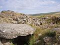
To the west of the top of the hill, there is a very old stone structure. It's called a long cairn. This cairn was built during the early Neolithic period. It is about 11 metres (36 ft) long. It was built using a natural granite rock formation, which makes it even longer.
The Summit Grave
At the very top of Chapel Carn Brea, you can find a special burial place. It's called an entrance grave. This grave is about 9 metres (30 ft) wide. It has an entrance facing south. It was built in the late Neolithic period.
The inside chamber of the grave was about 2.7 metres (8.9 ft) long. It was 1.1 metres (3.6 ft) wide and 1.2 metres (3.9 ft) high. This type of grave is unique to Penwith (west Cornwall) and the Isles of Scilly. They have a long, narrow room covered with big stone slabs. Large stones form a border around them. People believe these were places where many people were buried together.
Later, this entrance grave was covered by a much larger mound of stones, called a cairn. This new cairn was 4.6 metres (15 ft) high and 19 metres (62 ft) across. It had three stone walls built in circles. It also had a second small stone box, called a cist, for burials.
The Chapel and Beacon
The chapel that gave the hill its name was built on top of this large cairn. It was taken down in 1816. People said that holy men or monks lived there.
An old document from 1396 talks about money received from fishermen. This money was for burning an "ecclesiastical light." This was usually a fire basket or brazier. It was lit at the "Chapel of St Michael of Bree." This is the earliest record of a light used to guide ships in Cornwall.
Later Discoveries
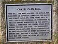
In the late 1800s, a person named William Copeland Borlase dug up the site. He built a new cairn. However, this cairn was later destroyed. This happened when a radar observation post was built during World War II. The Royal Air Force used this post. Today, there is a plaque near the car park. It honors those who served there.
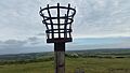
Summer Solstice Fires
The Old Cornwall Society still lights a beacon fire on Chapel Carn Brea every year. This happens on June 23rd. It celebrates the summer solstice, which is the longest day of the year.
Images for kids
-
Neolithic remains at the summit of Chapel Carn Brea
-
Plaque on Chapel Carn Brea
-
Mid-summer beacon


