
Port Glasgow facts for kids
Quick facts for kids Port Glasgow
|
|
|---|---|
 Port Glasgow |
|

Port Glasgow
|
|
| Area | 4.75 km2 (1.83 sq mi) |
| Population | 14,200 (2020) |
| • Density | 2,989/km2 (7,740/sq mi) |
| OS grid reference | NS321746 |
| • Edinburgh | 58 mi (93 km) |
| • London | 358 mi (576 km) |
| Council area | |
| Lieutenancy area | |
| Country | Scotland |
| Sovereign state | United Kingdom |
| Post town | PORT GLASGOW |
| Postcode district | PA14 |
| Dialling code | 01475 |
| Police | Strathclyde |
| Fire | Strathclyde |
| Ambulance | Scottish |
| EU Parliament | Scotland |
| UK Parliament |
|
| Scottish Parliament |
|
Port Glasgow is a town in Scotland, located in the Inverclyde area. It is the second-largest town there, found just east of Greenock. In 2011, about 15,414 people lived in Port Glasgow.
The town started as a small fishing village called Newark. It became important because large ships could not sail all the way up the shallow River Clyde to Glasgow. So, in 1668, Port Glasgow was created as a special port for Glasgow. It was first called 'New Port Glasgow' and then shortened to 'Port Glasgow' in 1775. The town soon became a center for building and repairing ships.
Port Glasgow grew from its original center, expanding up the hills. Many people now live in these newer areas, like Park Farm and Boglestone.
Contents
History of Port Glasgow
How Port Glasgow Began

The story of Port Glasgow begins with Newark Castle. Sir George Maxwell built this castle between 1450 and 1477. A small fishing village called Newark grew near the castle, where ships could anchor safely.
Later, the nearby village of Greenock grew into a market town. However, Glasgow merchants needed a better harbor for their large ships. These ships couldn't reach Glasgow because the River Clyde was too shallow.
In 1668, the City of Glasgow made a deal with Sir Patrick Maxwell of Newark Estate. They leased land near the castle to build a new harbor. This new port was called Newport Glasgow and quickly became a busy trading hub.
Trade and Decline
By 1710, Newport Glasgow was the main customs house on the Clyde. Ships brought in goods like tobacco, sugar, and cotton from the Americas. They also imported timber and iron from the Baltic Sea. These goods were then transported to Glasgow by road.
However, things changed in 1773 when the River Clyde was made deeper. This allowed ships to sail directly to Glasgow. As a result, Port Glasgow's importance as a port began to decline. By 1830, the port's income from customs duties had fallen.
Shipbuilding Takes Over

Shipbuilding became the main industry in Port Glasgow. In 1780, Thomas McGill opened one of the first shipyards. By the 1800s, Port Glasgow was a major shipbuilding center.
A famous ship called the Comet was built here in 1812. It was the first successful commercial steamboat in Europe. A replica of the Comet was made in 1962 and displayed in the town center.

Port Glasgow built about a quarter of all the ships launched on the Clyde. It also had yards for breaking up old ships. Today, most of the shipbuilding industry is gone, with only Ferguson Marine shipyard remaining.
Modern Changes
Many old buildings in Port Glasgow have been updated. The former Gourock Ropeworks building, which was once a sugar refinery, is now luxury apartments. A new shopping area has also been built near the town center.
Getting Around Port Glasgow
Port Glasgow has two train stations: Port Glasgow railway station in the town center and Woodhall railway station in the east. Both stations are on the Inverclyde Line, which offers frequent trains to Glasgow.
The town is also connected to Glasgow by the A8 road and the M8 motorway. Glasgow Airport is the closest airport, about 21 kilometers (13 miles) away.
Things to See in Port Glasgow
Newark Castle


Newark Castle is a historic building right by the Clyde River. It was built around 1484 and was home to the Maxwell Family for many years.
Today, the castle is a visitor attraction. It is maintained by Historic Scotland. You can also find Ferguson's shipyard right next to the castle. A park and walkway have been built nearby, offering nice views of the river.
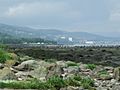
Parklea
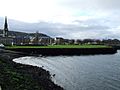
About 1 kilometer (0.5 miles) upstream from Newark Castle is Parklea. The National Trust for Scotland owns this area of the Clyde foreshore. For many years, it has been used as playing fields for the local community. This land was protected to prevent it from being taken over by shipyards.
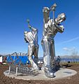
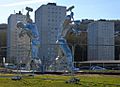
Shipbuilders of Port Glasgow Sculpture
In 2022, a new sculpture was placed in Coronation Park. It was created by artist John McKenna. This tall stainless steel sculpture shows two shipyard workers. They are using large hammers to shape metal plates for a ship's hull. The sculpture is sometimes called The Skelpies. It celebrates the town's long history of shipbuilding.
Coronation Park
Coronation Park opened in 1937 to celebrate the coronation of King George VI. It was built on the site of the old West Harbour. The park has a memorial to a sad boating accident in 1947, where 20 people lost their lives.
Sports in Port Glasgow
Port Glasgow has a history of football. Several successful football clubs have played here, including Port Glasgow Athletic F.C.. Today, Port Glasgow F.C., formed in 1948, plays its home games at a new stadium in Parklea.
Areas of Port Glasgow
Port Glasgow is made up of several different areas, including:
- Bardrainney
- Boglestone
- Bouverie
- Broadfield
- Chapelton
- Clune Park
- Devol
- Highholm
- Kelburn
- Kingston Dock
- Lilybank
- Mid Auchinleck
- Park Farm
- Parkhill
- Slaemuir
- Springhill
- Town Centre
- Woodhall
Images for kids
-
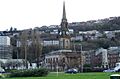
The Town Buildings, viewed from the site of the original harbour which was infilled, and formed Coronation Park in 1937.
-
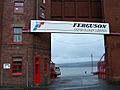
Ferguson's shipyard gate, before demolition in 2015/16
-
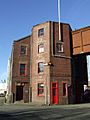
Ferguson's shipyard gatehouse before demolition in 2016
-
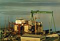
Scott Lithgow's Glen Yard in 1986 (site is now a retail park)
-
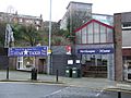
Main entrance to Port Glasgow railway station
-
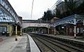
Port Glasgow railway station
-
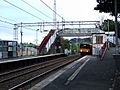
Woodhall railway station
-
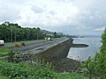
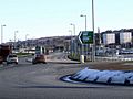
The A8 dual carriageway runs on land reclaimed from the Clyde in the east end of Port Glasgow
-
The A8 dual carriageway runs through former shipyard land in the west end of Port Glasgow.
-

The A8 at Port Glasgow, with the snow-covered Argyll hills beyond
-
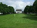
Parklea Farm
-
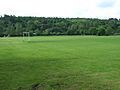
Parklea Playing Fields
-
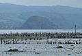
Timber Ponds at Parklea
-
Timber Ponds at Parklea
-
Shipbuilders of Port Glasgow
-
Shipbuilders of Port Glasgow detail
-

Shipbuilders of Port Glasgow detail
-
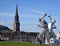
Shipbuilders of Port Glasgow and the Town Buildings
-
Shipbuilders of Port Glasgow and the Port Glasgow tower blocks
-
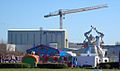
Shipbuilders of Port Glasgow and Ferguson marine shipyard
-

The main pedestrian entrance to the park
-
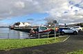
Slipway in use, MV Glen Sannox at Ferguson Marine shipyard
-
The boat slip at the park
-
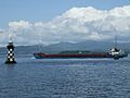
Ships pass very close to the park
-
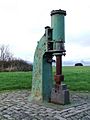
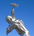
The steam hammer in Coronation Park


.jpg)


.jpg)
.jpg)
.jpg)


See also
 In Spanish: Port Glasgow para niños
