Charles River Reservation Parkways facts for kids
Quick facts for kids |
|
|
Charles River Reservation Parkways
|
|

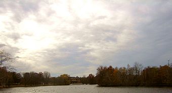
View along the Charles showing the Henderson Boathouse.
Soldiers Field Road to the left Greenough Blvd to the right. |
|
| Location | Boston, Newton, Watertown, and Weston, Massachusetts |
|---|---|
| Area | 65 acres (26 ha) |
| Built | 1895 |
| Architect | Charles Eliot Olmsted Brothers |
| MPS | Metropolitan Park System of Greater Boston MPS |
| NRHP reference No. | 05001530 |
| Added to NRHP | January 18, 2006 |
The Charles River Reservation Parkways are special roads that run along both sides of the Charles River in eastern Massachusetts. These roads are part of the beautiful Charles River Reservation and the Upper Charles River Reservation. They pass through several towns and cities in the greater Boston area, like Newton, Watertown, and Weston, Massachusetts.
The Charles River parks stretch from the Charles River Dam, where the river flows into Boston Harbor, all the way to Riverdale Park in the West Roxbury neighborhood of Boston. Most of these parkways are listed on the National Register of Historic Places. This means they are important historical sites. Some parts, like Storrow Drive and Memorial Drive, are listed as part of the Charles River Basin Historic District.
The other parkways, added to the historic list in 2006, go from Harvard Square to Newton Upper Falls. These roads along the river banks were improved in the early 1900s. This made them a continuous route for people to enjoy the park.
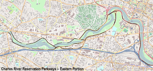
Eastern Parkways: Roads Near Boston
The eastern parkways are located within the Charles River Reservation. They stretch from Harvard Square to the area around Watertown Square in Watertown and Newton. These roads help people travel along the river and enjoy the scenery.
Here are some of the main roads in this eastern section:
- Charles River Road: This road is on the north side of the river in Watertown.
- Greenough Boulevard: Found on the north side, it connects the end of Memorial Drive in Cambridge to Arsenal Street in Watertown.
- Leo Birmingham Parkway: This road is a bit further from the river on the south side. It connects to Soldiers Field Road at both ends.
- Nonantum Road: This road is on the south side, starting from the end of Soldiers Field Road and going into Newton.
- North Beacon Street: A short road that links Greenough Boulevard with Charles River Road.
- Soldiers Field Road: This important road runs from the end of Storrow Drive through Allston and Brighton. It meets Nonantum Road near the North Beacon Street Bridge.
- Western Avenue/Arsenal Street: A short section that includes a bridge crossing the river.
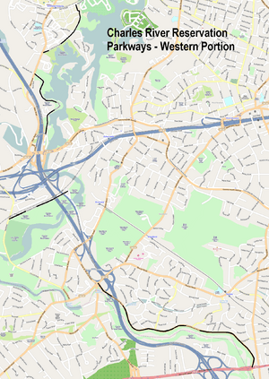
Western Parkways: Roads Upriver
The western parkways are found in the Upper Charles River Reservation. These roads are in different sections in Waltham, Weston, and Newton. They follow parts of the Charles River between Sawyer Road in Waltham and Route 9 near I-95.
Here are some of the roads in the western section:
- Norumbega Road: Located between South Street and Route 30 in Waltham.
- Quinobequin Road: Runs between Route 16 and Route 9 in Newton.
- Recreation Road: Found between I-95 and Park Street in Weston.
History of the Parkways
The idea for the Charles River parkways came from a plan by a famous landscape architect named Charles Eliot. He created this plan for the Metropolitan Parks Commission (MPC). The MPC later became the Metropolitan District Commission (MDC), and now it's the Massachusetts Department of Conservation and Recreation (DCR).
Work to buy the land for the parks along the Charles River began in 1895. Building the parks and parkways started soon after. One of the first roads built was the western part of Soldiers Field Road. It was part of the Charles River Speedway, which was an early track for racing, built between 1899 and 1910.
Other roads finished by 1910 included parts of North Beacon Street, Greenough Boulevard, and Charles River Road. Nonantum Road was built later, between 1910 and 1931. Leo Birmingham Boulevard was completed in 1936. It was built as a way to go around a slaughterhouse that the MDC couldn't buy at first. The slaughterhouse was eventually taken over in the 1940s, which allowed Soldiers Field Road to be fully completed.
For the upper part of the river, the original plan was to buy enough land to build continuous roads. However, there were many buildings and busy areas in Watertown and Waltham, which made this difficult. The oldest road in this area is Quinobequin Road, built in 1900. Recreation Road and Norumbega Road were both built in the 1930s. Later, the building of Interstate 95 and the Massachusetts Turnpike changed Recreation Road. These highways cut off some parts of the waterfront from easy access by land.
 | Selma Burke |
 | Pauline Powell Burns |
 | Frederick J. Brown |
 | Robert Blackburn |


