Chemnitzer Land Rural District facts for kids
Quick facts for kids
Chemnitzer Land
|
||
|---|---|---|
|
||
 |
||
| Country | ||
| State | Saxony | |
| Adm. region | Chemnitz | |
| Capital | Glauchau | |
| Area | ||
| • Total | 336 km2 (130 sq mi) | |
| Population
(2001)
|
||
| • Total | 139,800 | |
| • Density | 416.1/km2 (1,077.6/sq mi) | |
| Time zone | UTC+1 (CET) | |
| • Summer (DST) | UTC+2 (CEST) | |
| Vehicle registration | GC | |
| Website | landkreis-chemnitzer-land.de | |
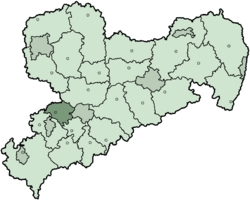
Chemnitzer Land was a special area, like a county, in the German state of Saxony. It was located in Germany. This district existed until 2008.
This area had a very large number of people living there. This was because the old government of East Germany wanted to make the area very focused on factories and manufacturing. This is called being very industrial.
The Chemnitzer Land district was created in 1994. It was formed by joining two older districts: Glauchau and Hohenstein-Ernstthal. In 2008, parts of the city of Zwickau became part of this district. The rest of Zwickau joined another district called Zwickauer Land.
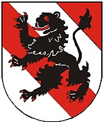
Chemnitzer Land's Coat of Arms
The symbol on the coat of arms is a lion. This lion is a special symbol often used for Saxony. The red and white pattern on the shield comes from the symbols of the old counts of Schönburg-Glauchau.
Towns and Communities
This district was made up of several towns and smaller communities. Here are some of them:
Main Towns
- Glauchau
- Hohenstein-Ernstthal
- Lichtenstein, Saxony
- Limbach-Oberfrohna
- Meerane
- Oberlungwitz
- Waldenburg
Other Communities
- Bernsdorf
- Callenberg
- Gersdorf
- Niederfrohna
- Oberwiera
- Remse
- Sankt Egidien
- Schönberg
 | Delilah Pierce |
 | Gordon Parks |
 | Augusta Savage |
 | Charles Ethan Porter |


