Chenega, Alaska facts for kids
Quick facts for kids
Chenega, Alaska
Caniqaq
|
|
|---|---|

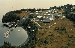
Aerial of Chenega Bay Village and boat harbor - Chenega Bay, Evans Island, 1989
|
|

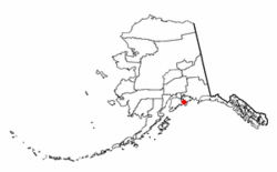
Location of Chenega, Alaska
|
|
| Country | United States |
| State | Alaska |
| Census Area | Chugach |
| Area | |
| • Total | 29.56 sq mi (76.57 km2) |
| • Land | 29.29 sq mi (75.85 km2) |
| • Water | 0.28 sq mi (0.72 km2) |
| Population
(2020)
|
|
| • Total | 59 |
| • Density | 2.01/sq mi (0.78/km2) |
| Time zone | UTC-9 (Alaska (AKST)) |
| • Summer (DST) | UTC-8 (AKDT) |
| Area code(s) | 907 |
| FIPS code | 02-12970 |
Chenega (pronounced chih-NEE-guh) is a small community in Alaska, located on Evans Island. It is part of the Chugach Census Area in the Prince William Sound region. The community is also known as Chenega Bay. It was built after a huge earthquake destroyed the original village.
In 2020, about 59 people lived in Chenega. Most of them are Alaska Natives, especially from the Chugach Alutiiq people. Chenega Bay has one school, Chenega Bay Community School, which teaches around 16 students from preschool to high school.
Contents
History of Chenega
The Original Chenega Village
The first village of Chenega was on Chenega Island. It was home to the Chenega tribe, a group of Alutiiq people. The name "Chenega" means "Beneath the Mountain." This village was a fishing community that existed long before Russians came to the area. It even had a post office from 1946 until it was destroyed.
When Chenega Was Destroyed
In 1964, a very strong earthquake, known as the Good Friday earthquake, caused a massive tsunami. This giant wave completely destroyed the original Chenega village. Out of 68 people living there, 26 sadly lost their lives. Almost all buildings were washed away, except for the school and one house.
After the tsunami, the people who survived were taken to Cordova. Later, they were permanently moved to Tatitlek.
Building Chenega Bay
Years later, a law called the Alaska Native Claims Settlement Act was passed. This law helped Alaska Native groups get back some of their traditional lands. Because of this, former residents of Chenega formed the Chenega Corporation. This group gained the right to choose over 76,000 acres of land.
In 1977, after looking at different places, a new town site was picked. It was at Crab Bay on Evans Island. After getting money to build roads and other important things, the new village, called Chenega Bay, was ready in 1984.
Every Good Friday, former and current Chenega residents gather to remember those lost in the 1964 earthquake. In 1989, on the 25th Good Friday after the earthquake, another disaster happened. The oil tanker Exxon Valdez crashed in Prince William Sound. This caused a huge oil spill that greatly harmed the fishing and wildlife, affecting Chenega and other nearby communities.
Where is Chenega?
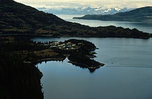
Chenega is located at 60.066327 degrees North and -148.010991 degrees West. The area of the community is about 29.1 square miles (75.4 square kilometers). Most of this area is land, with a small part being water. The village is quite isolated. You can only reach it by boat or by plane.
People of Chenega
Old Chenega (1880–1964) Population
The original Chenega village was first counted in the U.S. Census in 1880. At that time, 80 people lived there, all of whom were Alutiiq (also known as Sugpiaq). The population changed over the years, sometimes growing, sometimes shrinking. For example, in 1900, there were 140 people. By 1960, just before the earthquake, 61 people lived there. After the 1964 earthquake, the old village was no longer counted in the census because its residents had moved away.
New Chenega (Chenega Bay) (1990–) Population
The new community of Chenega Bay first appeared in the U.S. Census in 1990. It was founded in 1982 by people who used to live in the old village.
In 2000, there were 86 people living in Chenega Bay. Most of the people were Native American (73.26%), with some White people (22.09%) and a small number of people of two or more races (4.65%).
The community has a mix of ages. In 2000, about 33.7% of the population was under 18 years old. About 32.6% were between 25 and 44 years old. The average age in Chenega Bay was 30 years.
The average income for a household in Chenega Bay in 2000 was $53,750 per year. For families, the average income was $58,750. A small number of families and people lived below the poverty line.
| Historical population | |||
|---|---|---|---|
| Census | Pop. | %± | |
| 1880 | 80 | — | |
| 1890 | 73 | −8.7% | |
| 1900 | 140 | 91.8% | |
| 1930 | 90 | — | |
| 1940 | 95 | 5.6% | |
| 1950 | 91 | −4.2% | |
| 1960 | 61 | −33.0% | |
| U.S. Decennial Census | |||
| Historical population | |||
|---|---|---|---|
| Census | Pop. | %± | |
| 1990 | 94 | — | |
| 2000 | 86 | −8.5% | |
| 2010 | 76 | −11.6% | |
| 2020 | 59 | −22.4% | |
| U.S. Decennial Census | |||
See also
 In Spanish: Chenega (Alaska) para niños


