
Chillicothe, Texas facts for kids
Quick facts for kids
Chillicothe, Texas
|
|
|---|---|

Chillicothe post office, August 2006
|
|

Location of Chillicothe, Texas
|
|
 |
|
| Country | United States |
| State | Texas |
| County | Hardeman |
| Area | |
| • Total | 1.02 sq mi (2.64 km2) |
| • Land | 1.02 sq mi (2.64 km2) |
| • Water | 0.00 sq mi (0.00 km2) |
| Elevation | 1,401 ft (427 m) |
| Population
(2023)
|
|
| • Total | 542 |
| • Density | 531.4/sq mi (205.3/km2) |
| Time zone | UTC-6 (Central (CST)) |
| • Summer (DST) | UTC-5 (CDT) |
| ZIP code |
79225
|
| Area code(s) | 940 |
| FIPS code | 48-14680 |
| GNIS feature ID | 2409450 |
Chillicothe is a small city located in Hardeman County, Texas, in the United States. In 2020, about 549 people lived there. It's a place with a rich history and a friendly community.
Contents
History of Chillicothe
Chillicothe is in eastern Hardeman County. It sits along U.S. Route 287 and two important railway lines. These railways are the Fort Worth and Denver, and the Santa Fe.
The city began in the early 1880s. It grew quickly after the Fort Worth and Denver City Railway was built in 1887. A. E. Jones named the community "Chillicothe" after his hometown in Missouri. The town started near Wanderer's Creek. This was close to the R2 Ranch, which was owned by W. H. Worsham in the 1870s.
The first post office opened in 1883. Charles E. Jones was the first postmaster. In 1890, a big fire destroyed the town. But the people of Chillicothe didn't give up. They rebuilt the town south of the railway tracks.
Some of the first important people in Chillicothe included Sam L. Crossley. He became the first mayor in 1903. Other pioneers were J. J. Britt, J. A. Shires, and W. L. Ledbetter. Large buildings called wheat elevators were built in 1892 and 1893. The town officially became a city in 1907. At that time, about 800 people lived there.
Another railway, the Kansas City, Mexico and Orient Railway, started service in 1908. Chillicothe is sometimes called the "Iris Village." This is because many beautiful irises grow there. The population reached its highest point in 1930 with 1,610 people. Since then, the number of residents has slowly gone down.
For many years, Chillicothe had its own hospital. It served the community for 70 years. However, the Chillicothe Hospital closed its doors on July 22, 2019.
Geography and Climate
Where is Chillicothe?
Chillicothe is located in the eastern part of Hardeman County, Texas. U.S. Route 287 goes right through the middle of the city. This road leads southeast about 16 kilometers (10 miles) to Vernon. It also goes west about 13 kilometers (8 miles) to Quanah. Quanah is the main city and county seat of Hardeman County.
Land and Water
The city of Chillicothe covers an area of about 2.6 square kilometers (1.0 square mile). All of this area is land. There are no large bodies of water within the city limits. Wanderer's Creek flows past the western side of the city. This creek then flows north towards the Red River. The Red River forms part of the border with Oklahoma.
What is the Climate Like?
Chillicothe has a semi-arid climate. This means it is generally dry. It gets some rain, but not a lot. On climate maps, this type of weather is often shown as "BSk."
Population Facts
How Many People Live Here?
The 2020 United States census counted the number of people living in Chillicothe. In 2020, there were 549 people living in the city. These people made up 266 households. Within those households, there were 214 families.
The table below shows the different groups of people living in Chillicothe in 2020. This helps us understand the diversity of the city.
| Race | Number | Percentage |
|---|---|---|
| White (NH) | 300 | 54.64% |
| Black or African American (NH) | 13 | 2.37% |
| Native American or Alaska Native (NH) | 4 | 0.73% |
| Some Other Race (NH) | 1 | 0.18% |
| Mixed/Multi-Racial (NH) | 23 | 4.19% |
| Hispanic or Latino | 208 | 37.89% |
| Total | 549 |
Education
Students in Chillicothe attend schools run by the Chillicothe Independent School District. The city is also home to Chillicothe High School.
Notable People
- Monroe Parker – He was a college president.
- (Hoyt) Clay Puett – Born in Chillicothe in 1899, he invented the Electric Starting Gate. This device is used in horse racing.
- Herschel Ramsey – He was a professional football player.
- Lew Williams – He was a rockabilly singer.
Gallery
-
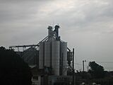
Grain elevator at Chillicothe


See also
 In Spanish: Chillicothe (Texas) para niños
