Clackline, Western Australia facts for kids
Quick facts for kids ClacklineWestern Australia |
|
|---|---|

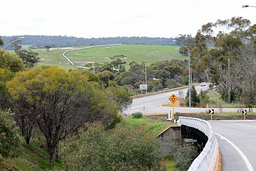
Clackline Brook Bridge from the west.
|
|
| Established | 1896 |
| Postcode(s) | 6564 |
| Elevation | 257 m (843 ft) |
| Area | [convert: needs a number] |
| Location | |
| LGA(s) | Shire of Northam |
| State electorate(s) | Central Wheatbelt |
| Federal Division(s) | Durack |
Clackline is a small town in the Wheatbelt area of Western Australia. It's located about 80 kilometres (50 miles) east-north-east of Perth, the capital city.
Contents
A Look at Clackline's Past
The name Clackline was first written down in 1879 by John Forrest, who later became the leader of Western Australia. We don't know where the name came from. A small community started here in the 1880s. This was because it was where the road from Perth to Newcastle met. The town officially became a town in 1896.
Clackline was also known as Clackline Junction. This was because it had important road and railway connections. It was a key point for the Eastern Railway lines. These lines went to Northam and Toodyay. The train service through Clackline stopped in 1966. This happened when a new railway route, the Avon Valley route, opened.
Where is Clackline Located?
Clackline is in the Wheatbelt region of Western Australia. It is about 80 kilometres (50 miles) east-north-east of Perth. It is also 17 kilometres (11 miles) south-west of Northam.
The Clackline Brook is a waterway that is about 11.6 kilometres (7.2 miles) long. It flows from near Clackline towards Mokine. Then it turns north and ends near Mokine Hill. You can also find the Clackline Nature Reserve on Refractory Road.
Who Lives in Clackline?
In 2021, about 330 people lived in Clackline.
What Does Clackline Produce?
The Clackline area is known for growing some of Australia's best quality export hay. This is a type of feed for animals. The area also has places that grow grapes for wine. There is also an olive grove that makes extra virgin olive oil.
Cool Places to Visit in Clackline
There are several interesting historical places in and around Clackline. Some of these are even listed as heritage sites.
Avro Anson Memorial: Remembering Airmen
The Avro Anson Memorial remembers four Royal Australian Air Force (RAAF) airmen. They died when their Avro Anson aircraft crashed near Clackline. This happened on 9 October 1942. The memorial is in a small park about 5 kilometres (3 miles) south-east of Clackline. It has a pile of rocks and a wooden cross. The names of the airmen are carved into the cross.
For many years, the memorial was forgotten and covered by plants. In the early 1980s, it was found again. Volunteers helped to fix it up in 1984. Since then, the RAAF Association holds a special service there every year.
Clackline Bridge: A Unique Structure
Clackline Bridge is an old road bridge in Clackline. It was part of the Great Eastern Highway until 2008. This bridge is special because it's the only one in Western Australia that crossed both a waterway and a railway line. It went over the Clackline Brook and the old Eastern Railway track. The bridge is mostly made of timber. It has a unique curved and sloped shape. This was needed because of the tricky land and the railway's path.
The bridge was designed in 1934. It was built to replace two dangerous railway crossings and a simple water crossing. Building started in January 1935 and finished quickly. It opened in August 1935. The bridge was made wider in 1959–60. Even with changes, it was still a bit dangerous. A new highway bypass was built between 2007 and 2008. People in the area were worried the old bridge would be removed. But it is still used today as part of the local roads. It is also listed as a heritage site.
Clackline Refractory: Making Bricks
The Clackline Refractory is an old brick-making site. It is located on Refractory Road in a valley near Great Eastern Highway. In 1898, a lot of good quality clay was found in Clackline. This led to the creation of a quarry and a refractory. A refractory is a place where special bricks are made. These bricks can handle very high heat.
By 1901, this industry was very important for Western Australia. The bricks from Clackline were used by many government groups. They were also used by gas companies and goldmines. The Clackline Refractory also made bricks for the pumping stations. These stations were part of the Goldfields Water Supply Scheme. This scheme brought water to the goldfields.
As of 2012, the site is mostly empty and not in good shape. There are still some stacks of ceramic products. You can see old kilns made of bricks with metal roofs. There is also a large brick chimney.
Lion Monument: A School's Tribute
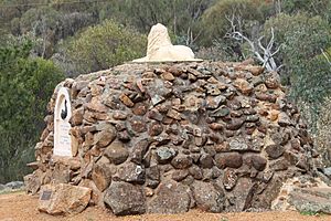
In 1929, the students and headteacher of Clackline School built a monument. They did this to celebrate 100 years since the British settled Western Australia. The monument has a sculpture of a lion. There is a plaque that says:
ERECTED by the PUPILS of CLACKLINE
to COMMEMORATE the CENTENARY
of the
BRITISH COLONISATION OF WEST
AUSTRALIA
MDCCCXXIX MDCCCCXXIX A D.
E.W.MEMBERY. H.T.
The person who sculpted the lion was Archie H Paton. There is a plaque nearby that honours him. This monument is a stopping point on the Kep Track. It is next to a picnic area and toilets.
Rail Heritage: A Train Museum
A restored train carriage is now a museum in Clackline. It was put there by the Clackline Railway Committee. This train carriage has been used for community events. These include farmers markets and even weddings. Now, it serves as the community post office. It is located south of Great Eastern Highway. You can find it across from the old general store. A walking trail goes under the highway and leads to the remains of the Clackline railway station.
After the general store and local post office closed, the Clackline Progress Association decided the community needed a local post office. In 2018, they asked for community support. People were very supportive. So, volunteers cleaned up the carriage and opened a community post office.
How to Get Around Clackline
Clackline mainly relies on its roads for transport. It is located next to Great Eastern Highway. This highway has bypassed the town since February 2008. The highway connects traffic south-west to Perth. It also goes north-east to Northam and beyond. Other important roads in the area are Clackline–Toodyay Road, which goes north to Toodyay. Spencers Brook Road heads south-east to Spencers Brook and then to York.
Learning in Clackline
Clackline used to have its own primary school. This was until the late 1970s. Clackline School opened in 1896. It was expanded and fixed up several times. In 1954, it moved to a new spot on the same road. The school closed down in 1976. But in 1980, it became a temporary location for the Avon Valley Church's school. Now, the closest primary schools to Clackline are in Northam, Bakers Hill, and Wundowie.
The nearest high schools and colleges are in Northam. These include Northam Senior High School, St Joseph's High School, C. Y. O'Connor College of TAFE, and the Muresk Institute.
Clackline in the News
Clackline is served by the Northam-based Avon Valley Advocate newspaper. People in Clackline can also read the statewide newspapers The West Australian and The Sunday Times.
 | John T. Biggers |
 | Thomas Blackshear |
 | Mark Bradford |
 | Beverly Buchanan |


