
Clarendon, Virginia facts for kids
Quick facts for kids
Clarendon, Arlington, Virginia
|
|
|---|---|

The Clarendon Metro station entrance in May 2008
|
|

Clarendon, Arlington, Virginia
Location in Northern Virginia

Clarendon, Arlington, Virginia
Location in Virginia

Clarendon, Arlington, Virginia
Location in the United States
|
|
| Country | |
| State | |
| County | |
| Time zone | UTC-5 (EST) |
| • Summer (DST) | UTC-4 (EDT) |
| ZIP Codes |
22201
|
| Area code(s) | 703 |
Clarendon is a lively neighborhood in Arlington County, Virginia. It sits between the areas of Rosslyn and Ballston. This area was named after Edward Hyde, 1st Earl of Clarendon, an important leader and writer during the English Civil War. The main roads here are Wilson Boulevard (which goes west) and Clarendon Boulevard (which goes east).
Contents
Exploring Clarendon's Location
Clarendon has a unique street layout. Many of its blocks are shaped like triangles instead of squares! The exact borders of Clarendon can be a bit tricky to define. People often use different ideas of where Clarendon begins and ends.
The heart of Clarendon includes the Clarendon Metro station. This station is part of the Metrorail system's Orange and Silver lines. You'll find it at Wilson Boulevard and Highland Street. Other important spots are Market Common Clarendon and the Whole Foods Market. As Clarendon has grown more popular, its unofficial borders have stretched out. It now reaches towards nearby Metro areas like Virginia Square and Courthouse.
A Look Back in Time: Clarendon's History

Clarendon was first planned out in 1900. It was built on a hill along the old Georgetown-Falls Church Road, which is now Wilson Boulevard. Clarendon became the main "downtown" area of Arlington County after electric trolleys arrived in 1896.
In the early 1900s, two interurban trolley lines met in Clarendon. This was a short distance west of where the Clarendon Metro station is today. One trolley line traveled from Rosslyn to Clarendon. The Metrorail's Orange Line now follows a path very similar to this old trolley route.
The other trolley line came from downtown Washington. It crossed the Potomac River and traveled along Washington Boulevard to reach the Clarendon station. Trolleys from both lines then went between Clarendon, Ballston, and Falls Church. Some even went as far as the towns of Vienna and Fairfax. These trolley lines were used until the mid-1930s. They eventually stopped running because more people started using cars. Also, the Great Depression made it hard for them to stay in business.
The village of Clarendon was officially named on March 31, 1900. In 1920, people tried to make Clarendon its own city, but this idea was not approved by the courts.

Over time, Clarendon became the main shopping area for Northern Virginia. Big Department stores like J.C. Penney and Sears opened stores here. Other shops spread west along Wilson Boulevard and Fairfax Drive.
The Arlington Post Office was built in 1937. It was the first federal building constructed in Arlington County after the American Civil War. Before this, Arlington's mail was handled in Washington, D.C.. Inside the post office, you can see murals painted in 1939 by Auriel Bessemer. These murals show scenes from Arlington's history. In 2000, the building was named after Joseph L. Fisher, a former U.S. representative. This building is an important landmark for Arlington County and is listed on the National Register of Historic Places.

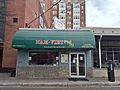
By 1975, Clarendon became known as "Little Saigon". This was because many Vietnamese refugees moved to Washington D.C. and Arlington. They came because of the area's closeness to the nation's capital and existing connections. This neighborhood became home to many Vietnamese grocery stores, restaurants, and cafes. These businesses served the large Vietnamese community. The low rents during the construction of the Clarendon Metro station also attracted Vietnamese immigrants. Many of these early Vietnamese businesses have since closed, but Nam Viet is one restaurant that remains today.
After the Clarendon Metro station opened in December 1979, the area changed a lot. New luxury apartments, office buildings, and fancy chain stores were built. This process is called gentrification, where an area becomes more expensive and upscale. Even with these changes, some of the original businesses are still around.
Clarendon Today: A Hub of Activity
.jpg)
Clarendon hosts several fun events each year. These include Arlington's Neighborhood Day parade, which happens every May. There's also the Mardi Gras parade and Tax Blues Night. The biggest event is "Clarendon Day," held in mid-October. This festival features live music, food booths from local restaurants, and sales of clothing, jewelry, and antiques. Kids can enjoy games and rides, and there's even an ice-cream eating contest!
Every spring, Clarendon also hosts the Clarendon Cup. This is part of the Armed Forces Cycling Classic, one of the biggest professional and amateur bicycle races in the U.S.
Before the COVID-19 pandemic, a farmers market was held at Clarendon's Central Park. It took place on Wednesday afternoons from spring through mid-December. You could find organic produce, baked goods, plants, and other handmade items there.
Images for kids
-
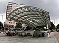
The Clarendon Metro station entrance in May 2008
-
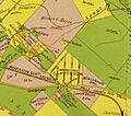
Map from 1900 by Howell & Taylor, showing Clarendon in Arlington, VA, from a 1900 map
-
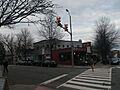
Clarendon street scene in 2013
-
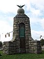
American Legion War Memorial at intersection of Wilson Boulevard and Clarendon Boulevard in Clarendon (2008)
-
Nam-Viet, the first Vietnamese restaurant to open in Clarendon, seen in December 2021
-
Intersection of Wilson Boulevard and N. Highland Street in Clarendon, with Clarendon Metro Station entrance and Olmsted Building in background (2008)
.jpg)
