Clayton, Oklahoma facts for kids
Quick facts for kids
Clayton, Oklahoma
|
|
|---|---|

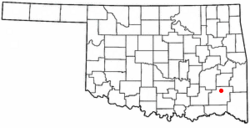
Location of Clayton, Oklahoma
|
|
| Country | United States |
| State | Oklahoma |
| County | Pushmataha |
| Area | |
| • Total | 1.70 sq mi (4.41 km2) |
| • Land | 1.68 sq mi (4.35 km2) |
| • Water | 0.02 sq mi (0.06 km2) |
| Elevation | 607 ft (185 m) |
| Population
(2020)
|
|
| • Total | 555 |
| • Density | 330.36/sq mi (127.54/km2) |
| Time zone | UTC-6 (Central (CST)) |
| • Summer (DST) | UTC-5 (CDT) |
| ZIP code |
74536
|
| Area code(s) | 539/918 |
| FIPS code | 40-14900 |
| GNIS feature ID | 2413210 |
Clayton is a small town in northern Pushmataha County, Oklahoma, United States. In 2020, about 555 people lived there.
Contents
History of Clayton
Early Days as Dexter
Clayton was first known as Dexter. A post office opened in Dexter, Indian Territory, on March 31, 1894. It was named after Dexter Chapman, who lived in the area.
Dexter was located in a place called Wade County, Choctaw Nation. This was part of the Indian Territory, before Oklahoma became a state.
Becoming Clayton
The post office name officially changed to Clayton, Indian Territory, on April 5, 1907. People think the town was renamed after Clayton, Missouri. It might also have been named after William H.H. Clayton. He was a judge who helped Oklahoma become a state.
Clayton's Importance in the Region
Clayton is the biggest town in northern Pushmataha County. It is an important place for trading. This is because it is about 36 miles from Antlers, the county seat.
Flagpole Mountain Fire Tower
Flagpole Mountain has a fire tower. This tall metal tower was once used to watch for fires. It was part of a network of towers. People would staff these towers to spot wildfires. It is the only tower left in Pushmataha County. It is not used anymore. But you can still see for miles from the tower.
Modern Clayton
Clayton is still doing well economically. It has a local economy. The town has a public school, several churches, and many businesses and homes.
Historic Auditorium
The Clayton High School Auditorium (Oklahoma) is a special building. It is important for its history and design. It is now on the National Register of Historic Places. This means it is a protected historic site. The building is a rare example of Works Progress Administration (WPA) architecture. It was one of only two single-use auditoriums built by the WPA.
You can find more about Clayton's history at the Pushmataha County Historical Society.
Geography and Nature
Where is Clayton Located?
Clayton is located at 34°35′16″N 95°21′25″W / 34.58778°N 95.35694°W. The town covers about 1.7 square miles. Most of this area is land. A very small part is water.
Natural Surroundings
Clayton is in the Kiamichi River valley. Flagpole Mountain is to its west. Other mountains are to its east. These mountains are over 1,600 feet tall.
Near Clayton, you can find McKinley Rocks. This is a cool collection of huge rocks on a mountain top. South of town is Clayton Lake State Park. This park is surrounded by pine trees. Northwest of town is Sardis Lake (Oklahoma). This lake was made by a dam built by the U.S. Army Corps of Engineers. The Pushmataha Wildlife Refuge is also nearby. It offers great views from its mountain top.
Utilities
- Telephone, Internet, and Digital TV Services are provided by Hilliary Communications.
Population Information
| Historical population | |||
|---|---|---|---|
| Census | Pop. | %± | |
| 1950 | 612 | — | |
| 1960 | 615 | 0.5% | |
| 1970 | 718 | 16.7% | |
| 1980 | 833 | 16.0% | |
| 1990 | 636 | −23.6% | |
| 2000 | 719 | 13.1% | |
| 2010 | 821 | 14.2% | |
| 2020 | 555 | −32.4% | |
| U.S. Decennial Census | |||
In 2000, there were 719 people living in Clayton. There were 335 households. About 191 families lived in the town.
Most people in Clayton were White (74.41%). About 19.33% were Native American. Some people were from two or more races. A small number were Hispanic or Latino.
About 28.4% of households had children under 18. Many households (41.8%) were married couples. About 40% of all households were individuals living alone. This included 22.7% of people aged 65 or older.
The population was spread out by age. About 25.3% were under 18. About 20% were 65 or older. The average age was 38 years old.
See also
 In Spanish: Clayton (Oklahoma) para niños

