Clendenin, West Virginia facts for kids
Quick facts for kids
Clendenin, West Virginia
|
||
|---|---|---|

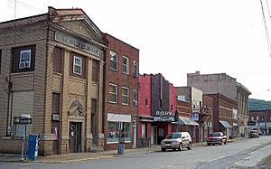
Maywood Avenue in downtown Clendenin in 2007
|
||
|
||

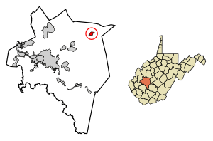
Location of Clendenin in Kanawha County, West Virginia.
|
||
| Country | United States | |
| State | West Virginia | |
| County | Kanawha | |
| Government | ||
| • Type | Strong City Council | |
| Area | ||
| • Total | 1.52 sq mi (3.94 km2) | |
| • Land | 1.44 sq mi (3.73 km2) | |
| • Water | 0.08 sq mi (0.21 km2) | |
| Elevation | 623 ft (190 m) | |
| Population
(2020)
|
||
| • Total | 850 | |
| • Estimate
(2021)
|
850 | |
| • Density | 762.83/sq mi (294.56/km2) | |
| Time zone | UTC-5 (Eastern (EST)) | |
| • Summer (DST) | UTC-4 (EDT) | |
| ZIP code |
25045
|
|
| Area code(s) | 304 | |
| FIPS code | 54-16012 | |
| GNIS feature ID | 1537398 | |
Clendenin is a small town located in Kanawha County, West Virginia, in the United States. It sits right next to the beautiful Elk River. In 2020, about 850 people lived in Clendenin.
Contents
History of Clendenin
Early Days and Industries
In the 1800s, Clendenin was a small place where Big Sandy Creek met the Elk River. It was first called Chilton. Back then, people mostly worked in the timber (logging) and coal mining industries. In 1846, a special type of coal called cannel coal was found nearby. This coal was great for making artificial gas. Clendenin was officially planned out in 1877.
Growth and New Discoveries
A railroad called the Coal and Coke railroad was built through Clendenin in 1893. This helped the logging industry grow even more. Around 1900, the first natural gas well was drilled in the area. This led to one of the biggest oil and gas fields in West Virginia.
The town officially became a city in 1904. It was named after the Clendenin family, who were early settlers in the Kanawha River Valley. In 1920, the world's first plant for making petrochemicals (chemicals from oil and gas) was built here. This plant was the original Union Carbide Corporation facility. Other important industries included timber, coal, natural gas, oil, and salt.
Boom Years and Changes
From 1900 to 1930, Clendenin grew a lot. Many important buildings were built, like schools, churches, banks, and shops. When the Union Carbide plant moved away, the town's economy slowed down. However, Clendenin remained an important center for trade in the surrounding counties. Later, in the 1980s, a major highway (Interstate 79) was built around the town, which changed things again.
Recent Times and Recovery
Clendenin was badly damaged by a big flood in 2016. The town worked hard to recover, and by 2020, most of the repairs were done. Some homes still needed to be rebuilt or taken down.
The current mayor of Clendenin is Kay Summers. Town leaders, including the mayor, are chosen in elections every two years. Local groups are working to help the town's economy and culture grow.
Geography and Climate
Where is Clendenin?
Clendenin covers about 1.51 square miles (3.91 square kilometers). Most of this area is land, with a small part being water.
Clendenin's Weather
The weather in Clendenin usually has hot and humid summers. Winters are generally mild to cool. The area has a humid subtropical climate. This means it gets a good amount of rain throughout the year. On average, Clendenin experiences fog on 236 days a year and rain or snow on 153 days.
Population Information
| Historical population | |||
|---|---|---|---|
| Census | Pop. | %± | |
| 1910 | 815 | — | |
| 1920 | 1,263 | 55.0% | |
| 1930 | 1,217 | −3.6% | |
| 1940 | 1,200 | −1.4% | |
| 1950 | 1,475 | 22.9% | |
| 1960 | 1,510 | 2.4% | |
| 1970 | 1,438 | −4.8% | |
| 1980 | 1,373 | −4.5% | |
| 1990 | 1,203 | −12.4% | |
| 2000 | 1,116 | −7.2% | |
| 2010 | 1,227 | 9.9% | |
| 2020 | 850 | −30.7% | |
| 2021 (est.) | 850 | −30.7% | |
| U.S. Decennial Census | |||
How Many People Live Here?
In 2010, there were 1,227 people living in Clendenin. These people lived in 524 households, with 335 of them being families. The town had about 852 people per square mile.
Most of the people in Clendenin (98.7%) were White. A small number were African American, Asian, or from two or more races. About 0.1% of the population was Hispanic or Latino.
Age and Households
The average age in Clendenin in 2010 was 43.5 years old.
- About 21.7% of residents were under 18.
- About 18.7% were 65 years or older.
Most households (49%) were married couples living together. About 31.7% of all households had people living alone.
Arts and Culture
The Clendenin Historic District is a special area in town. It is listed on the National Register of Historic Places. This means it has important historical buildings and sites.
Parks and Recreation
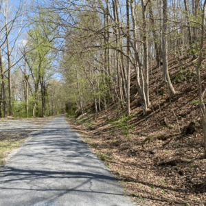
The Elk River Trail is a fantastic place for outdoor fun! This trail is about 75 miles (121 kilometers) long and goes from Clendenin all the way to Gassaway, West Virginia. Along the trail, you can see waterfalls, go fishing, or enjoy canoeing and kayaking on the river.
Education
Students in Clendenin attend schools in the area.
- Kindergarten through 5th grade students go to Clendenin Elementary School. This school is located within the town.
- Students in grades 6-8 attend Elkview Middle School. This school is about 7 miles from Clendenin.
- High school students (grades 9-12) go to Herbert Hoover High School (West Virginia). The original high school was destroyed in the 2016 flood. A new Herbert Hoover High School opened in August 2023 in Elkview.
Notable People
Some famous people have come from Clendenin:
- Bill Karr: A football player who played for the Chicago Bears from 1933 to 1938.
- Billy Joe Mantooth: A college football star who later played in the NFL for the Philadelphia Eagles and Houston Oilers.
- Dave Stephenson: Another NFL player who played for the Los Angeles Rams and Green Bay Packers.
Mothman Sighting Claims
Some people in the Clendenin area have reported seeing strange creatures. They described seeing "a large brown winged man take flight" or "a large gray creature whose eyes 'glowed red' when car headlights picked it up." This alleged creature became known as the Mothman.
See also
 In Spanish: Clendenin (Virginia Occidental) para niños
 | Emma Amos |
 | Edward Mitchell Bannister |
 | Larry D. Alexander |
 | Ernie Barnes |


