Cleveland, Missouri facts for kids
Quick facts for kids
Cleveland, Missouri
|
|
|---|---|

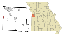
Location of Cleveland, Missouri
|
|
| Country | United States |
| State | Missouri |
| County | Cass |
| Area | |
| • Total | 1.50 sq mi (3.90 km2) |
| • Land | 1.49 sq mi (3.85 km2) |
| • Water | 0.02 sq mi (0.05 km2) |
| Elevation | 988 ft (301 m) |
| Population
(2020)
|
|
| • Total | 650 |
| • Density | 437.42/sq mi (168.89/km2) |
| Time zone | UTC-6 (Central (CST)) |
| • Summer (DST) | UTC-5 (CDT) |
| ZIP code |
64734
|
| Area code(s) | 816 |
| FIPS code | 29-14770 |
| GNIS feature ID | 2393561 |
Cleveland is a small city located in Cass County, Missouri, in the United States. It's part of the larger Kansas City metropolitan area. In 2010, about 661 people lived here. By 2020, the population was 650.
Contents
History of Cleveland
Cleveland was first known by a different name: Maxwell. It was named after Thomas T. Maxwell, who planned out the city in 1891. Later, the city's name was changed to Cleveland. This new name honored Grover Cleveland, who was the President of the United States at that time. A post office has been serving the community since 1891.
Geography and Location
Cleveland is found at specific coordinates: 38.675829 degrees North and -94.595229 degrees West. These numbers help pinpoint its exact spot on a map.
Area and Water Features
According to the United States Census Bureau, the city covers a total area of about 1.50 square miles (3.90 square kilometers). Most of this area, about 1.48 square miles (3.85 square kilometers), is land. A small part, around 0.02 square miles (0.05 square kilometers), is water.
Population and People
The number of people living in Cleveland has changed over the years. Here's how the population has grown and shifted:
| Historical population | |||
|---|---|---|---|
| Census | Pop. | %± | |
| 1910 | 170 | — | |
| 1920 | 169 | −0.6% | |
| 1930 | 159 | −5.9% | |
| 1940 | 146 | −8.2% | |
| 1950 | 163 | 11.6% | |
| 1960 | 216 | 32.5% | |
| 1970 | 256 | 18.5% | |
| 1980 | 485 | 89.5% | |
| 1990 | 506 | 4.3% | |
| 2000 | 592 | 17.0% | |
| 2010 | 661 | 11.7% | |
| 2020 | 650 | −1.7% | |
| U.S. Decennial Census | |||
Cleveland's 2010 Census Details
In 2010, a detailed count of the population was done. This count, called a census, showed there were 661 people living in Cleveland. These people lived in 250 households, and 196 of these were families.
Who Lives in Cleveland?
The city had about 446.6 people living per square mile. There were 260 housing units available. Most residents, about 95.6%, identified as White. Smaller groups included African American (0.2%), Native American (0.9%), and Asian (0.9%). About 2.4% of people identified with two or more races. Around 2.1% of the population was of Hispanic or Latino background.
Households and Families
Out of the 250 households, 37.6% had children under 18 living there. Many households, 63.2%, were married couples living together. Some households were led by a female (8.8%) or a male (6.4%) without a spouse present. About 21.6% of households were not families.
A small number, 18.4% of all households, had only one person living in them. About 7.2% of households had someone aged 65 or older living alone. On average, each household had 2.64 people, and each family had 2.99 people.
Age and Gender in Cleveland
The average age of people in Cleveland was 40.9 years. About 25.3% of residents were under 18 years old. Around 5% were between 18 and 24. People aged 25 to 44 made up 25.5% of the population. The largest group, 31.1%, was between 45 and 64 years old. Finally, 13% of residents were 65 years or older. When looking at gender, 51.6% of the population was male, and 48.4% was female.
See also
 In Spanish: Cleveland (Misuri) para niños
 | William Lucy |
 | Charles Hayes |
 | Cleveland Robinson |

