Cleveland Foundation Centennial Lake Link Trail facts for kids
Quick facts for kids Cleveland Foundation Centennial Lake Link Trail |
|
|---|---|
 |
|
| Length | 1.3 miles (2.1 km) |
| Location | Cleveland, Ohio, U.S. |
| Established | August 13, 2015 |
| Trailheads | Northern terminus: Whiskey Island Southern terminus: Northern terminus of the Ohio and Erie Canal Towpath Trail |
| Use | Bicycling, hiking, walking |
| Difficulty | Easy |
| Season | Year-round |
| Sights | Cuyahoga River, downtown Cleveland skyline |
| Surface | Asphalt |
| Right of way | Former Cleveland and Mahoning Valley Railroad |
| Maintained by | Cleveland Metroparks |
| Website | clevelandmetroparks.com |
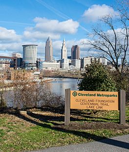
The Cleveland Foundation Centennial Lake Link Trail, also known as the Lake Link Trail, is a popular path for cycling, hiking, and walking in Cleveland, Ohio. This trail is special because it follows the old path of the Cleveland and Mahoning Valley Railroad tracks. The city of Cleveland owns the trail, and Cleveland Metroparks takes care of it.
The trail got its name from The Cleveland Foundation, a local group that helps communities. They gave $5 million to help build the trail. The first part of the trail, which is about 1.3-mile (2.1 km) long, opened in August 2015. The next part opened in August 2017. The middle section will be built once the ground at Irishtown Bend is made stable. A bridge to connect the trail to Whiskey Island was planned to be built between 2019 and 2020.
Contents
Discover the Trail's History: From Railroad to Pathway
This trail follows the path of an old railroad called the Cleveland and Mahoning Railroad (C&M). This railroad started in 1848. It was built to connect Cleveland to other towns and even into Pennsylvania.
The railroad needed to cross the Cuyahoga River in Cleveland. At first, the tracks ended on the east side of the river. But in 1863, another company, the Atlantic and Great Western Railroad, took over and finished the tracks across the river. They also built a new train station.
Later, in 1886, the railroad tracks were extended even further. They went across the western part of the Scranton Flats, curved around Irishtown Bend, and crossed the Old Ship Channel of the Cuyahoga River to reach Whiskey Island. This allowed trains to connect with another big railroad line.
The railroad built many docks and freight areas along the river. These were used to load and unload goods, especially coal. The area was very busy with trains and boats. In 1912, a large coal loading dock was built near where the Detroit–Superior Bridge is today. The C&M railroad even had a huge rail yard with eight tracks just for the busy traffic around Irishtown Bend.
What Happened to the Old Tracks?
Over time, trains stopped using these tracks. In 1982, a company called Conrail removed about 3.3 miles (5.3 km) of track in Cleveland. Some of the old track areas were used for new roads. For example, Riverbed Street was made wider in 1985, covering part of the old C&M track.
The land where the tracks used to be was also sold. In 1993, the old rail yard on Whiskey Island was sold to a real estate company. Later, in 2004, Cuyahoga County bought this land and the rest of Whiskey Island. Most of this area became Wendy Park, a public park.
The land where the trail now runs, from the Old Ship Channel to the Cuyahoga River, was also sold. This land would later become part of the new trail.
Creating the Trail: A Community Effort
The idea for the Lake Link Trail started with some interesting discoveries. In 1987, an archeologist named Dr. Alfred M. Lee began digging at Irishtown Bend. His team found many clues about the homes and lives of people who used to live there.
These discoveries made people want to protect the area and make it open to the public. In 1990, several groups helped fund a study about preserving the Cuyahoga River valley. This study, finished in 1992, suggested creating an 18-mile (29 km) network of parks and trails. It specifically recommended a biking and hiking trail at Irishtown Bend to connect Whiskey Island to the north and the Ohio and Erie Canal Towpath Trail to the south.
Even though some businesses wanted a new road through Irishtown Bend, city planners decided to turn Riverbed Street into a biking and hiking path. They also planned to make the area a public park.
Challenges: Keeping the Hillside Safe
One big challenge for the trail was that the hillside at Irishtown Bend has always been a bit unstable. The soil, the steepness of the hill, and water in the ground can cause the land to slowly slide towards the river. Usually, this sliding is very slow, just a few inches a year.
Around 2004 or 2005, the hillside started sliding much faster. In 2005, big cracks appeared in Riverbed Street. The city tried to fix it, but the cracks came back quickly, so the street had to be closed for safety. Experts studied the hill and warned that it could suddenly collapse into the Cuyahoga River.
Because of this instability, it became clear that the area wasn't safe for homes or businesses. So, the city of Cleveland, Cuyahoga County, and other groups started talking about turning the abandoned railroad land into something new. In 2009, they released a plan called the "Flats Connections Plan." This plan suggested turning the old track bed into a biking and hiking trail. It also proposed building a new bridge over the Old Ship Channel to connect the trail to Wendy Park.
Getting the Land and Designing the Path
To build the trail, they first needed to get the land. In 2008, a group called The Trust for Public Land (TPL) started talking with the company that owned the old track bed. In 2009, TPL bought the rights to about 1.3 miles (2.1 km) of the former railroad path. This was a big step toward making the trail a reality.
The first designs for the trail, then called the Lake Link Trail, were funded by a grant from The George Gund Foundation. This money helped hire experts to plan the trail, estimate costs, and find more funding.
In 2011, The George Gund Foundation gave another $2 million to the project. Then, in 2014, The Cleveland Foundation gave a huge gift of $5 million. Because of this generous donation, Cleveland Metroparks decided to rename the path the Cleveland Foundation Centennial Lake Link Trail. Cleveland Metroparks became responsible for designing, building, and maintaining the trail.
Building the Trail Sections
By late 2014, the trail design was almost finished, and work began to clear the land. About $8 million had been raised for building the trail and a bridge. Cleveland Metroparks planned to build the trail in four parts. The first part was across the Scranton Peninsula. In January 2015, the government gave a $3.3 million grant for the construction.
A report in February 2015 recommended that Metroparks wait to build the trail along Irishtown Bend. This was because the hillside needed to be made stable first.
The first part of the trail, the 0.25-mile (0.40 km) south leg, opened on August 13, 2015. Important officials, including the United States Secretary of the Interior, attended the opening.
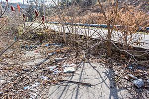
In 2016, Cleveland Metroparks received more grants to help plan for the hillside stabilization and to create the park and middle section of the trail. They also began building the northern section of the trail in August 2016. This area had been filled with trash, and parts were even underwater.
The second part of the trail opened on June 9, 2017. The design for the park and the middle section of the trail at Irishtown Bend is still being reviewed. Construction on this part will begin once the design is approved and funding for stabilizing the hillside is secured.
The Whiskey Island Bridge
A new pedestrian bridge is planned to connect the trail to Whiskey Island. Early plans for this bridge started in 2011. Several designs were considered, including a suspension bridge and a cable-stayed bridge.
Cleveland Metroparks took over the bridge planning in 2014. They looked at new designs for the 600-foot (180 m) bridge over the Old Ship Channel. By June 2015, a design by Miguel Rosales and his team was chosen. The bridge was estimated to cost about $6 million.
However, the design work for the Whiskey Island bridge slowed down in late 2015. Metroparks decided to make some changes to the design to help control costs. They also decided to improve the existing Willow Avenue Bridge so cyclists and walkers could use it. The new bridge design was shortened to 365 feet (111 m). In August 2016, Cleveland Metroparks received a large grant of $7.95 million from the federal government to help pay for the bridge's construction.
Cleveland Metroparks planned to start building the Whiskey Island pedestrian bridge in the summer of 2018 and hoped to finish it by the end of 2019.
What the Trail is Like Today
The Cleveland Foundation Centennial Lake Link Trail is owned by the city of Cleveland and cared for by Cleveland Metroparks.
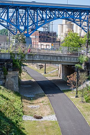
The northern part of the trail is about 0.5-mile (0.80 km) long. It starts near River Road and Mulberry Avenue. It goes southeast, passing under several roads like the Cleveland Memorial Shoreway and Main Avenue. For much of this section, the trail is in a deep trench with stone walls.
The southern part of the trail is about 0.25-mile (0.40 km) long. It starts at Columbus Road and crosses the Scranton Flats. It goes under the Hope Memorial Bridge. Two new bridges help it cross over train tracks and Scranton Road. Finally, it connects with the Ohio and Erie Canal Towpath Trail near University and Scranton Roads.
41°29′41″N 81°42′24″W / 41.494598°N 81.706799°W


