Cockburn River facts for kids
Quick facts for kids Cockburn River |
|
|---|---|

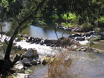
A rock-chute, on the Cockburn River, near Tamworth
|
|
| Country | Australia |
| State | New South Wales |
| Region | IBRA: New England Tablelands |
| District | Northern Tablelands |
| Municipality | Tamworth |
| Physical characteristics | |
| Main source | Moonbi Range near Limbri 493 m (1,617 ft) |
| River mouth | confluence with the Peel River west of Nemingha 384 m (1,260 ft) |
| Length | 33.6 km (20.9 mi) |
| Basin features | |
| Tributaries |
|
The Cockburn River is a river in New South Wales, Australia. It's a perennial river, which means it flows all year round. This river is part of the larger Namoi river system. The Namoi River then flows into the huge Murray–Darling basin, which is a very important water system for much of Australia.
Contents
Where Does the River Flow?
The Cockburn River starts in the western hills of the Moonbi Range. This is near a place called Limbri. From there, it flows generally towards the west-southwest.
River's Journey and Length
As it flows, the Cockburn River is joined by four smaller streams called tributaries. These are like smaller rivers or creeks that feed into a bigger one. The river eventually meets the Peel River at a spot called Nemingha. This meeting point is called a confluence.
The Cockburn River is about 33 kilometres (21 mi) (around 20 miles) long. During its journey, it drops about 109 metres (358 ft) (about 358 feet) in height.
Towns Along the River
The Cockburn River flows through or near several towns. These include Limbri, Moonbi, Kootingal, Tintinhull, and Nemingha. A train line, the Main North railway line, also runs alongside the river valley for some distance.
History and Naming
European explorers first found the Cockburn River on September 4, 1818. This was during an expedition led by John Oxley. He was the Surveyor-General of New South Wales at the time. Oxley decided to name the river in honour of Admiral Sir George Cockburn.
Interesting Facts About the Cockburn River
The Cockburn River is known for being one of the fastest-flowing rivers in the southern half of the world!
What Lives in the River?
The river is home to different kinds of fish. You might find native fish like catfish and yellow belly here. However, there are also European carp, which are not native to Australia. These carp have caused problems for the native fish, making them harder to find.
How People Use the Land Around the River
Along the banks of the Cockburn River, there are small areas where farmers grow crops using irrigation (watering their fields). The hills around the river are mostly used for grazing, which means they are used for farm animals like cattle or sheep to eat grass.
 | Jackie Robinson |
 | Jack Johnson |
 | Althea Gibson |
 | Arthur Ashe |
 | Muhammad Ali |

