Col du Pourtalet facts for kids
Quick facts for kids Col du Pourtalet |
|
|---|---|

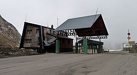
The disused frontier post in April 2011
|
|
| Elevation | 1,794 m (5,886 ft) |
| Location | Pyrénées-Atlantiques, Huesca, Spain Laruns, Pyrénées-Atlantiques, France |
| Range | Pyrenees |
| Coordinates | 42°48′19″N 0°25′07″W / 42.805140°N 0.418670°W |
The Col du Pourtalet (also known as El Portalet or Portalet d'Aneu) is a famous mountain pass in the Pyrenees mountains. It serves as a border crossing between France and Spain. This pass is very high up, reaching about 1,794 meters (5,886 feet) above sea level. It connects two beautiful valleys: the Ossau Valley in France and the Tena Valley in Spain.
Exploring the Pass
The Col du Pourtalet is an important route for travel and trade between France and Spain. It's a place where you can see stunning mountain views.
Roads and Travel
On the Spanish side, the road leading to the pass is called the A-136. This road connects to towns like Biescas and Huesca. On the French side, the road is known as the D934. It links the pass to towns such as Laruns, Oloron-Sainte-Marie, and Pau.
Even in winter, the pass usually stays open. However, if there's a lot of snow, it might close for a few days for safety.
Border Crossing
The Col du Pourtalet used to have a busy border checkpoint. But now, because of something called the Schengen Agreement, the checkpoint is no longer used. The Schengen Agreement allows people to travel freely between many European countries without needing to stop at border controls.
Where is it Located?
The French part of the pass is in the town of Laruns, which is in the Pyrénées-Atlantiques area. The Spanish part is in the town of Sallent de Gállego, located in the province of Huesca. This means the pass is truly split between two countries!
See Also
 In Spanish: Portalet para niños
- List of mountain passes
 | Aaron Henry |
 | T. R. M. Howard |
 | Jesse Jackson |


