Colchuck Lake facts for kids
Quick facts for kids Colchuck Lake |
|
|---|---|

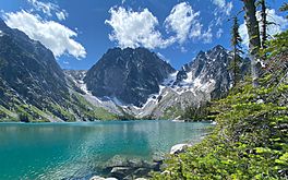
Aasgard Pass (left) and Dragontail Peak center above Colchuck Lake
|
|
| Location | Chelan County, Washington, United States |
| Coordinates | 47°29′52″N 120°51′13″W / 47.4976478°N 120.8534945°W |
| Primary outflows | Mountaineer creek |
| Basin countries | United States |
| Surface area | 87.8 acres (0.355 km2) |
| Surface elevation | 5,574 ft (1,699 m) |
Colchuck Lake is a beautiful freshwater lake. It is located in Chelan County, Washington, on the western side of The Enchantments mountains.
The lake is about 15 miles away from the town of Leavenworth, Washington. It sits in the southeast part of the Icicle Creek area. You can reach Colchuck Lake by hiking a 4-mile trail. The name "Colchuck" comes from an old language called Chinook Jargon. It means "cold waters."
Contents
History of the Lake
In 1926, a group called the Icicle Irrigation District wanted to use water from Colchuck Lake. They needed the water for irrigation, which means watering crops and farms.
In 1927, they received permission to take water from the lake. They also got approval to raise the lake's water level. This was because there wasn't enough water in the summer for all the farms.
How Big is Colchuck Lake?
Colchuck Lake covers about 87.8 acres (which is about 0.35 square kilometers). Its surface is usually around 5,570 feet (1,700 meters) above sea level. This can change a little depending on how much water is in the lake.
The area that drains into the lake is quite large, about 941 acres (3.8 square kilometers). This means a lot of rainwater and snowmelt flows into Colchuck Lake. The lake can hold a lot of water, estimated at 1,570 acre-feet.
The Dam at Colchuck Lake
Colchuck Lake has a special dam built in the late 1930s. This dam is made of cement and rocks. It has an opening called a spillway in the middle. The spillway helps control how much water flows out of the lake.
There's also a valve that controls the water flow. This valve is about 20 feet (6 meters) south of the spillway. It lets water out through a pipe into a small creek. This creek then flows into Mountaineer Creek, which is a branch of Icicle Creek.
What the Area is Like
Colchuck Lake is in a rocky area. The ground is made of hard rocks like granite. These rocks are part of the Mount Stuart Batholith.
The trail leading to the lake starts with sandy soil. As you get closer to the lake, the trail becomes rockier with many boulders.
How Colchuck Lake is Used
The Icicle and Peshastin Irrigation Districts use Colchuck Lake. They store water there for irrigation. This means the water helps farms grow crops.
The lake collects water from a large area of about 3,800 acres. This helps the lake refill easily, even when there isn't much rain. The dam at the lake helps control the water. It has a pipe and a gate that can be opened. This allows water to be released when needed.
Releasing water from the lake helps keep Icicle Creek full. This is especially important in late summer when water levels are usually low.
The 2017 Fire
On August 11, 2017, lightning started a large fire. It happened about 15 miles southwest of Leavenworth, Washington. The fire spread into the areas around Eightmile Lake, Stuart Lake, and Colchuck Lake.
The fire burned right up to the shoreline of Colchuck Lake. It damaged a large part of the land around the lake.
How to Get to Colchuck Lake
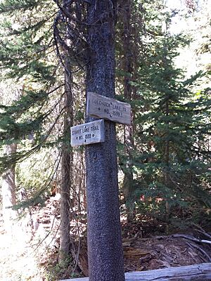
To get to Colchuck Lake, you start on a hiking trail. The trail begins at the end of USFS Road 7601. This trail is called Stuart Lake Trail #1599.
About 1.5 miles into the hike, you will cross over Mountaineer Creek on a wooden bridge. Less than a mile after the bridge, the trail splits. If you go right, you will head to Stuart Lake. If you go left, you will be on Colchuck Lake Trail #1599.1, which leads to Colchuck Lake. There is another bridge over Mountaineer Creek shortly after the trail splits.
You need a special permit to hike in the Colchuck Lake area. This is called an Alpine Lake Wilderness permit. You can get it yourself at the trailhead.
 | Bessie Coleman |
 | Spann Watson |
 | Jill E. Brown |
 | Sherman W. White |


