Eightmile Lake facts for kids
Quick facts for kids Eightmile Lake |
|
|---|---|

Eightmile Lake Mosaic Burn
|
|
| Location | Chelan County, Washington, United States |
| Coordinates | 47°31′13.1″N 120°51′55.1″W / 47.520306°N 120.865306°W |
| Primary inflows | Eightmile creek |
| Primary outflows | Eightmile creek |
| Basin countries | United States |
| Water volume | 76.6 acres (31.0 ha) |
| Surface elevation | 4,641 ft (1,415 m) |
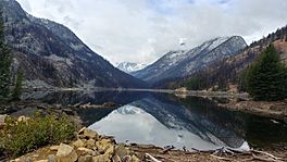
Eightmile Lake is a beautiful lake located in Chelan County, Washington. It sits on the eastern side of Eightmile Mountain. This lake is actually a reservoir, meaning it's a natural lake that has been changed to store water. It forms at the very beginning of Eightmile Creek.
The lake is about 10 miles away from the city of Leavenworth, Washington. You can reach it by hiking a 3.5-mile trail (USFS Trail No. 1552). This trail starts from USFS Road 7601. Remember, you'll need a special permit to visit the Eightmile Lake area.
Contents
Exploring Eightmile Lake's Surroundings
What is the geology like around Eightmile Lake?
Eightmile Lake is nestled in a basin with rocky soil. The ground here is made of a type of rock called tonalite. This bedrock is quite close to the surface, about 3 feet down. There's also a large area on the northeast side of the lake with big rocks and other natural deposits from landslides. The trail leading to the lake has sandy soil and many boulders.
Eightmile Lake is in a high alpine area that was shaped by glaciers. It's a bit barren, but you can find heather and other wildflowers. There are also evergreen trees, especially larch pines, growing nearby.
What is the climate like at Eightmile Lake?
Eightmile Lake has a cool, northern forest climate, sometimes called a hemiboreal climate. The average temperature throughout the year is about 2°C (36°F).
- The warmest month is August, with an average temperature of 17°C (63°F).
- The coldest month is January, with an average of −10°C (14°F).
The area gets about 705 millimeters (28 inches) of rain each year. December is the wettest month, with about 111 millimeters (4.4 inches) of rain. July is the driest, with only about 16 millimeters (0.6 inches) of rain.
How Eightmile Lake Helps People
Eightmile Lake is managed by the Icicle and Peshastin Irrigation Districts (IPID). They use the lake to store water for irrigation, which means watering crops and fields. The lake collects water from a large area of about 3,800 acres. This means it can refill easily, even when there isn't much rain.
The lake's water is held back by a small dam. This dam is made of rocks and masonry, with special wooden barriers called stop logs. There's also an earthen part of the dam that connects to the hillside. The dam has a pipe and a gate to control how much water flows out of the lake.
When the stop logs are in place, the lake can fill up to an elevation of about 4,671 feet. This setup allows controlled amounts of water to be released. This extra water helps Icicle Creek have enough flow, especially in late summer when water levels are usually low.
The 2017 Fire and Eightmile Lake
How did the Jack Creek Fire affect the lake?
On August 11, 2017, a lightning strike started a large forest fire. This fire, known as the Jack Creek Fire, was about 15 miles southwest of Leavenworth, Washington. The fire spread into the areas around Stuart Lake and Eightmile Lake. It burned right up to the shoreline of Eightmile Lake.
A large part of the land that drains water into the lake was damaged by the fire. This fire might change how water flows into Eightmile Lake in the future.
Restoring Eightmile Lake
What is the Icicle Strategy?
In 2016, Chelan County and the Washington State Department of Ecology created a plan called the Icicle Strategy. This plan aimed to solve water shortages in the Icicle Creek area. These shortages affected irrigation, fish habitats, and fishing for both Native American tribes and other groups.
The plan also worked to improve streamflow and water availability after the 2017 forest fires. In 2018, the Washington State Department of Ecology approved the Icicle Strategy.
How did the Icicle Strategy help Eightmile Lake?
The Icicle Strategy also included fixing the dam at Eightmile Lake. This allowed the lake to store more water than before. Some people were worried about possible flooding around the lake and damage to trails and plants. However, the good things that came from the plan were seen as more important. These benefits included protecting habitats, helping fish move freely, screening fish from water diversions, and making water use more efficient.
The earthen part of the dam had eroded, which meant it couldn't hold as much water as it was designed to. The restoration work fixed this erosion. Now, the dam can raise the water level in Eightmile Lake to about 4,667 feet, helping it store more water for the community.
Images for kids
 | Isaac Myers |
 | D. Hamilton Jackson |
 | A. Philip Randolph |


