
Eightmile Mountain facts for kids
Quick facts for kids Eightmile Mountain |
|
|---|---|

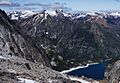
Southeast aspect, from Aasgard Pass
|
|
| Highest point | |
| Elevation | 7,996 ft (2,437 m) |
| Prominence | 956 ft (291 m) |
| Isolation | 2.97 mi (4.78 km) |
| Parent peak | Cashmere Mountain |
| Geography | |

Eightmile Mountain
Location in Washington (state)

Eightmile Mountain
Location in the United States
|
|
| Location | Chelan County Washington state, U.S. |
| Parent range | Cascade Range |
| Topo map | USGS Jack Ridge |
| Climbing | |
| Easiest route | class 2 Hiking |
Eightmile Mountain is a tall mountain in Washington state. It stands about 7,996 feet (2,437 meters) high. You can find it in Chelan County. This mountain is part of the Alpine Lakes Wilderness area. It is managed by the Okanogan-Wenatchee National Forest.
Eightmile Mountain is part of the Wenatchee Mountains. These mountains are a smaller group within the larger Cascade Range. The closest taller mountain is Cashmere Mountain, about 3 miles (5 km) away. Mount Stuart is also nearby, about 4 miles (6 km) to the south. Water from Eightmile Mountain flows into Trout Creek and Eightmile Creek. These creeks then join Icicle Creek, which flows into the Wenatchee River. People love this mountain for spring skiing. It also offers amazing views of the Stuart Range.
Contents
What's the Weather Like?
Most weather systems start over the Pacific Ocean. They then travel east towards the Cascade Range. When these weather systems reach the tall Cascade Mountains, they are forced to rise. As the air goes up, it cools down. This causes the moisture in the air to turn into rain or snow. This process is called orographic lift.
Because of this, the Cascade Mountains get a lot of rain and snow. This is especially true during the winter months. In winter, the weather is often cloudy. But in summer, high-pressure systems over the Pacific Ocean become stronger. This often means there are clear skies and lots of sunshine.
How Was Eightmile Mountain Formed?
The Alpine Lakes Wilderness has some very rugged land. You can see jagged peaks, sharp ridges, and deep valleys carved by glaciers. There are also huge granite walls. More than 700 mountain lakes dot the area.
Geological events that happened millions of years ago shaped this land. These events created the different types of land and the big changes in height across the Cascade Range. This also led to the different climates you find there.
Earth's Plates and Volcanoes
The Cascade Mountains began forming millions of years ago. This was during a time called the late Eocene Epoch. At that time, the North American Plate was slowly moving over the Pacific Plate. This movement caused many volcanic eruptions.
Also, small pieces of the Earth's outer layer, called terranes, helped form the North Cascades. These pieces came from both the ocean floor and the continents. This happened about 50 million years ago.
Ice and Reshaping the Land
During the Pleistocene period, which started over two million years ago, glaciers were very active. These huge sheets of ice moved forward and then melted back many times. As they moved, they scraped and shaped the land. They left behind piles of rock and debris.
The last time glaciers melted away from the Alpine Lakes area was about 14,000 years ago. By 10,000 years ago, they had moved north of the Canada–US border. The river valleys in this area have a U-shape. This U-shape was created by these recent glaciers. The mountains were also lifted up and broken by faults. These processes, along with the glaciers, created the tall peaks and deep valleys you see in the Alpine Lakes Wilderness today.
Images for kids
-
Eightmile Mountain and Colchuck Lake from the top of Aasgard Pass

