Comanche Creek, Colorado facts for kids
Quick facts for kids
Comanche Creek, Colorado
|
|
|---|---|

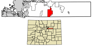
Location of the Comanche Creek CDP in Arapahoe County, Colorado.
|
|
| Country | |
| State | |
| County | Arapahoe County |
| Government | |
| • Type | unincorporated community |
| Area | |
| • Total | 21.768 sq mi (56.380 km2) |
| • Land | 21.692 sq mi (56.183 km2) |
| • Water | 0.076 sq mi (0.197 km2) |
| Elevation | 5,627 ft (1,715 m) |
| Population
(2020)
|
|
| • Total | 442 |
| • Density | 20.305/sq mi (7.840/km2) |
| Time zone | UTC-7 (MST) |
| • Summer (DST) | UTC-6 (MDT) |
| ZIP Code |
Strasburg 80136
|
| Area codes | 303 & 720 |
| GNIS feature | Comanche Creek CDP |
Comanche Creek is a small community in Colorado, United States. It's located in Arapahoe County. Even though it's not an official town, it's recognized as a census-designated place (CDP). This means the United States Census Bureau collects information about the people living there.
Comanche Creek is part of a larger area called the Denver–Aurora–Lakewood, CO Metropolitan Statistical Area. This is a big region that includes Denver and other nearby cities. In 2020, about 442 people lived in Comanche Creek. The local post office that serves the area is in Strasburg.
Where is Comanche Creek?
Comanche Creek is located in Arapahoe County, Colorado. It covers an area of about 56.38 square kilometers (or about 21.77 square miles). Most of this area is land, with a small part, about 0.197 square kilometers (or 0.076 square miles), being water.
Who Lives in Comanche Creek?
The United States Census Bureau keeps track of how many people live in different places. They first started counting people in Comanche Creek as a CDP for the 2010 Census.
Here's how the population has changed:
| Comanche Creek CDP, Colorado | ||
|---|---|---|
| Year | Pop. | ±% |
| 2010 | 369 | — |
| 2020 | 442 | +19.8% |
| Source: United States Census Bureau | ||
See also
 In Spanish: Comanche Creek para niños


